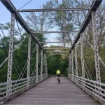

The first shots of the American Revolution – “The shot that was heard around the world,” according to Ralph Waldo Emerson – were fired across North Bridge, about 17 miles outside of Boston, Massachusetts. (Of course, Mr. Emerson might have some interesting ideas, as his house sat within sight of the bridge, but we’ll let that thought lie.) I’m sure I learned about the events at North Bridge in history class (I tested out of having to take American History 1, after all), but there’s nothing quite like seeing the site to firmly place the events of history in your mind. Today, it’s a sleepy little bridge between forests and fields, with the Minute Man Statue on the far side and a monument to the battle on the near side.
Quick Stats
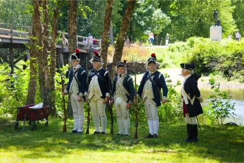
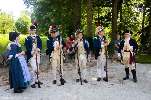
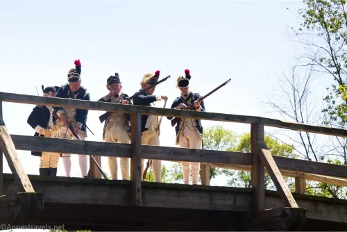
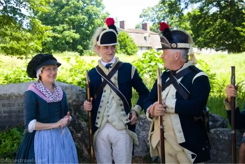
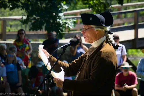
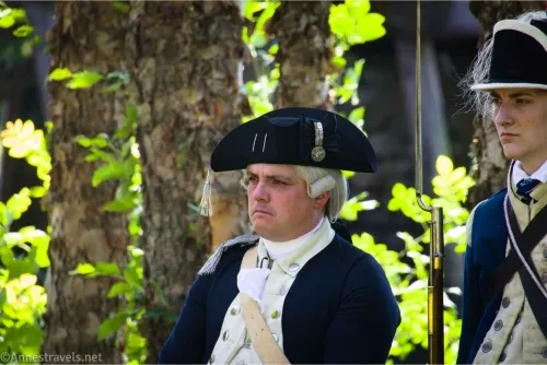
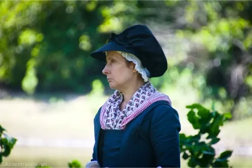
On July 4th, Minute Man National Historical Park puts on a good show at various places throughout the park, but one of the biggest attractions is the reading of the Declaration of Independence at North Bridge. Not only is the reader in full period costume, but people dressed like the Continental Army shoot muskets off the bridge. It’s a neat way to celebrate Independence Day if you happen to be in the area!
We parked at the nearby parking lot (large, but not quite big enough for 4th of July) approximately 42.4695923, -71.3486242. Walk across the road, pass the bathroom, and follow the wide, packed-gravel path down to the bridge. (If you continued to parallel the road instead of turning down to the bridge, you’d pretty quickly end up at “The Manse,” inhabited by various authors including Ralph Waldo Emerson and Nathaniel Hawthorne.)
The bridge itself is nice but not particularly impressive. It’s been rebuilt a few times over the years, so it’s not authentic, though an original wood plank is preserved in the visitor center (which you can see if you continue across the bridge and up the hill).
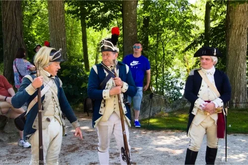
The costumed people with their muskets were standing in the shade beside the monument on the east side of the bridge, so I took a few photos before going over to the grassy area where the Declaration of Independence was to be read.
The NPS had set up a microphone system and there are benches, but all the benches were well and filled by the time I arrived, and many more were sitting on blankets or standing around. I decided to walk over to the far side and stand under a tree – just be careful, as I’m pretty sure the tree had poison oak on it.
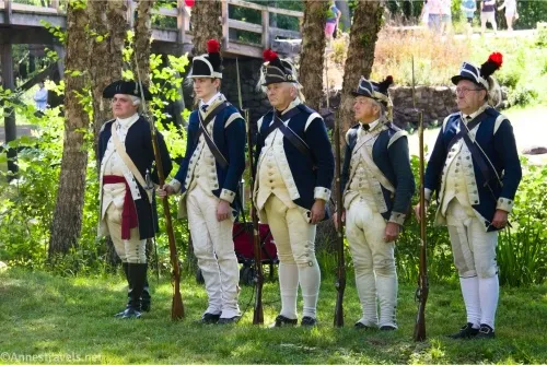
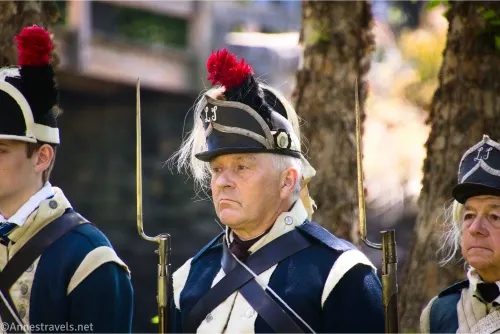
The costumed members of the “army” marched in, then a park ranger in period costume introduced the guy who would do the reading. I have to admit, I enjoyed seeing so many authentic three-cornered hats in real life!
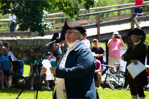
The guy who did the reading (in period costume, of course!) did a great job! And while I’m sure I had to read the Declaration of Independence for school, I’d forgotten all but the first couple of paragraphs. It was fascinating to hear it with a modern political ear and compare the colonists’ grievances to the gripes I see on social media. Some things just don’t change, and others are so outside our current existence that we’re happy to leave them in the past.
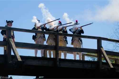
After the reading, the members of the “Continental Army” marched out onto the bridge. I was worried that they were going to shoot downstream (away from everyone), but they shot into the water upstream. A kayak even floated through at one point; I’m pretty sure they would have had to wait if he’d come a minute earlier, but since they were finished, they let him go. I scrambled down the bank to a little beach beside the river so I could photograph the proceedings from below.
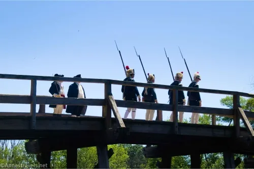
Four of the militia removed the bayonets from the muskets (you can absolutely fire a musket with a bayonet on it (per a guy on the beach by the river who was explaining all this to his kids), but the bayonet makes it difficult to reload the musket). Then they aimed, and their leader (a fifth guy) gave them the signal to fire. They did this another two times. It was very fun to see and try to photograph!
The show over, we wandered across the bridge and then up the path toward the North Bridge Visitor Center. There were a few views from the path, but the garden at the top was the truly beautiful part.
The gardens are around the viewpoint (so if you’re not sure where to turn, follow the signs for the viewpoint). It was interesting to see North Bridge from above, even if it’s not spectacular.
From there, we went into the visitor center. It’s mostly a gift shop, but it does have restrooms and a water bottle filling station. There is also one small room set aside to history. I think their 7-foot-tall mannequins were a bit overkill (especially when it’s portraying a day when an average man’s height was around 5ft. 8in.), but the map was neat.
There is much more to see in Minute Man National Historical Park, but we were about done and drove over to Bedford Farms Ice Cream – it was really good; my only complaint was that there was no place to sit after being on our feet all day!
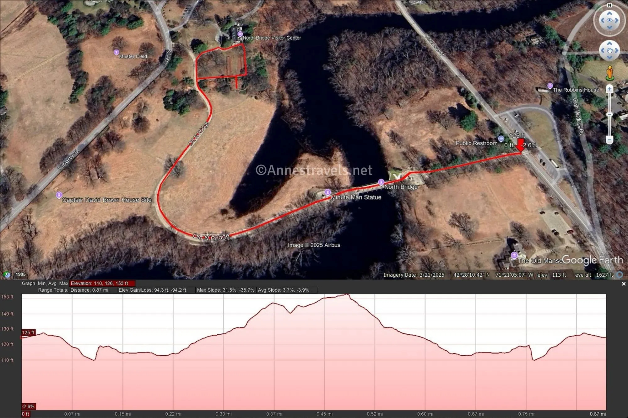
Round Trip Trail Length: I went about 1.2 miles with all my walking around, etc.
Elevation Gain: 94ft. (110ft to 153ft.)
Facilities: Visitor services, a gift shop, water, and restrooms at the North Bridge Visitor Center
Fees: None

Trail Notes: While we walked up to the visitor center (and there’s a pretty good hill between the bridge and the viewpoint!), there is parking there, as well, if you’d rather drive. Monuments on both sides of the bridge honor the Minute Men and the battle that was fought here (set up 50 years after the American Revolution began). I expect this area is pretty quiet on non-holidays, and it would be a peaceful place to walk. There is much more to see in the area, so do some research before you go!
Trail 
Road ![]()
Signs ![]()
Scenery ![]()
![]()
![]()
Would I go 100 miles out of my way for this? ![]()
![]()
![]()
Overall Rating: 
![]()
GPS Coordinates for North Bridge
TH at the crosswalk: 42.4693770°, -071.3488050° (42°28.16262′, -071°20.92830′ / 42°28’09.7572″, -071°20’55.6980″) (127ft.) (0.0)
North Bridge: 42.4690330°, -071.3506790° (42°28.14198′, -071°21.04074′ / 42°28’08.5188″, -071°21’02.4444″) (112ft.) (550ft.)
Turnoff for the gardens & viewpoint: 42.4702820°, -071.3530470° (42°28.21692′, -071°21.18282′ / 42°28’13.0152″, -071°21’10.9692″) (143ft.) (0.3)
Viewpoint: 42.4701600°, -071.3524740° (42°28.20960′, -071°21.14844′ / 42°28’12.5760″, -071°21’08.9064″) (131ft.) (0.4)
Visitor Center (back porch): 42.4707990°, -071.3524700° (42°28.24794′, -071°21.14820′ / 42°28’14.8764″, -071°21’08.8920″) (141ft.) (0.5)
End at crosswalk: 42.4693770°, -071.3488050° (42°28.16262′, -071°20.92830′ / 42°28’09.7572″, -071°20’55.6980″) (127ft.) (0.9)

The gpx file for North Bridge can be downloaded – please note that this and the GPS Coordinates are for reference only and should not be used as a sole resource when hiking this trail.
Download GPX File size: 5.6 KB Downloaded 398 times
(Note: I do my best to ensure that all downloads, the webpage, etc. are virus-free and accurate; however, I cannot be held responsible for any damage that might result, including but not limited to loss of data, damages to hardware, harm to users, from use of files, information, etc. from this website. Thanks!)
Getting to North Bridge
The roads around Concord are crazy enough that there are too many for me to safely give you directions. The best I can do is to tell you how to get there from Boston and then give you GPS coordinates for the parking area and the visitor center parking area.
Coordinates for the parking area: 42.4695923, -71.3486242
Coordinates for the North Bridge Visitor Center parking area: 42.4714604, -71.353278
From Boston, get on I-93N; take Exit 22 for MA-16 W/Mystic Valley Parkway. Continue onto MA-16W for 1.9 miles. At the traffic circle, take the second exit onto Alewife Brook Parkway, then, after 1.4 miles, use the right two lanes to take the MA-2 W ramp toward Concord. Use any lane to turn right onto MA-2 W. After 6.5 miles, keep left to continue on Concord Turnpike; after this, you want to stay straight on MA-2 W after 1.9 miles and another 1.0 miles. Take Exit 125 for MA-2 A E toward Concord and Lincoln, then use the left lane to take the ramp to Concord Center. 1.3 miles later, turn left onto Lexington Road for 0.3 miles. At the traffic circle, continue straight onto Monument Square, then take a quick right onto Monument Street for 0.6 miles. The parking area will be on the right.
Don’t Feel Like Being a Tourist?
If you want to do more than just be a tourist at Minute Man National Historical Park, this book can help you out! It includes information only locals would know as well as how to get the most out of your visit. Buy your copy here (affiliate link; there is no extra cost for you)