
The Great Allegheny Passage is most famous as a rails-to-trails – and it deserves its fame. By connecting seamlessly into the C&O Canal Path, bikers can travel all of the way from Pittsburg, PA to Washington, D.C. pretty much without having to travel any roads. How cool is that? I decided to do a short section of the trail near Meyersdale, Pennsylvania on a summer’s day (well, two days… but I’ll describe it as one), traveling between the Salisbury Viaduct and the Maryland state line. Along the way, I enjoyed old trestles, a museum, the Eastern Continental Divide, a few nice views, and a really neat tunnel!
Quick Stats
(This post contains affiliate links – there is no extra cost to you, but I may receive a small commission if you click and link and buy something.)

I’m going to pretend that we parked at the semi-official gravel parking area near the Salisbury Viaduct on Johnny Popper Road and then traveled straight to the Maryland state line/Mason-Dixon Line. In reality, we started at Salisbury, crossed the bridge and came back (1.1 miles), drove to the Deal Trailhead, did an out-and-back to the Maryland state line (8.0 miles), then an out-and-back to Meyersdale (14.8 miles), and the next morning, another out-and-back from Meyersdale to the end of the Salisbury Viaduct (4.0 miles – yes, that’s 27.9 miles in just over 24 hours). But that’s super complicated, which is why I’ll be talking about it in a little more of a straight line. Point to point (one way) between the end of the Salisbury Viaduct and the MD state line is about 13.5 miles according to official sources or 27 miles RT if you don’t have a shuttle vehicle.

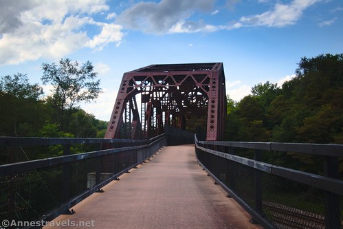
So starting from the semi-official parking in a gravel lot off of Johnny Popper Road near the Salisbury Viaduct, we took our bikes and turned right. Almost immediately, we arrived at the Salisbury Viaduct.
There are a few signs on this (east) side of the bridge about its construction, history, etc. But the real fun is in crossing the viaduct itself.
There are great railings, and the surface is paved, so it’s not really vertigo-inducing (or maybe it’s just that you know you can’t fall off too easily).

If you look over the left side, you can see where a second track could have been installed.
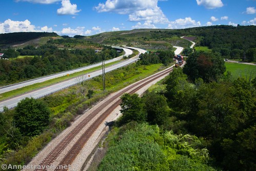
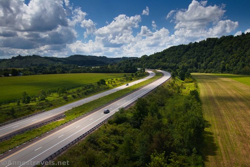
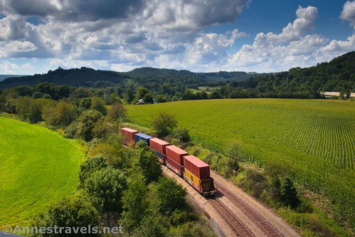
You’ll cross over Mason-Dixon Highway, an active CSX rail line, US-219 (a divided highway), Casselman River, and several farmer’s fields.

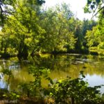
On the far side, you’ll come to a small country cemetery not too far from Mile Marker 34. Nearby signs tell of the history of the area and a few stories of those whose graves are nearby. When you’re done enjoying the scenery (there’s a picturesque farm nearby, too), ride back across the Salisbury Viaduct.

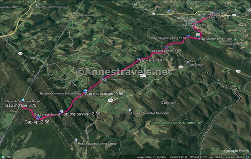
The trail for the next 10.3 miles has a pretty consistent 4% grade. “Yay!” you think. “That’s easy!” It is – for about 5 miles. By then, your legs are beginning to burn, and you’re wondering how you could be this badly out of shape. Don’t worry; it’s not just you; many people struggle with the constant grade. There is a little bit of downhill coming!

It’s almost exactly 2 miles between the Salisbury Viaduct and Meyersdale. Along the way, you’ll pass under this old bridge.
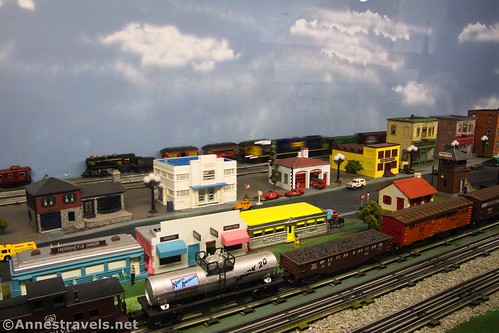
Mile marker 32 is in Meyersdale, not too far from the Meyersdale visitor center. Stock up on bathroom breaks, water, etc. here – it’s the last you’ll see of civilization for a while (there are several restaurants not far from the trail, but I didn’t check them out). There is pretty ample parking at the visitor center, too.

Actually, while you’re in Meyersdale, be sure to tour the old caboose and see the train sets in the visitor center. They’re pretty cool!
It might have seemed a shock to suddenly exit the trees and find yourself in Meyersdale, but it’s even faster to leave Meyersdale behind, and you’re quickly back in the trees.
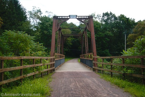
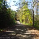
The next excitement is 1.7 miles later in the “town” of Glade City (there’s a town? I couldn’t tell!) The old Bollman Bridge is a unique structure in that it’s made of iron. Iron bridges were never very popular, but they were easy for unskilled workers to assemble, since each piece had a number cast into it as a unique identifier. This one was constructed in 1871 to allow the B&O Railroad to cross nearby Willis Creek. As railroads needed heftier steel bridges, this one was moved in 1910 to act as a farm road bridge over a different section of the B&O Railroad. It was moved again in 2006 to be part of the GAP (Great Allegheny Passage), effectively saving it from demolition.
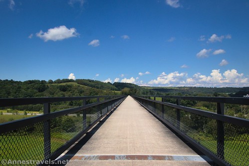
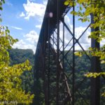
Keep riding another 0.6 miles to the Keystone Viaduct. This is an old rail bridge that carries the trail over Flaughtery Creek and a road. Because of the angle of the tracks vs. the surrounding topography, it’s actually a fairly long bridge.

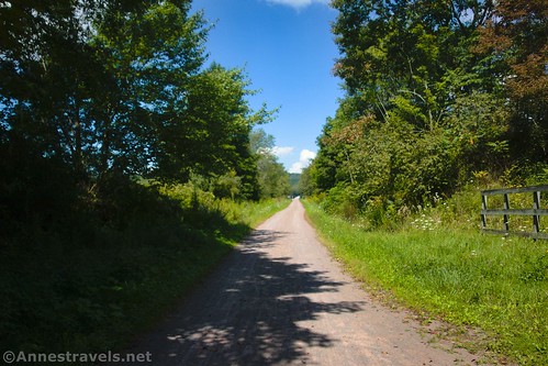
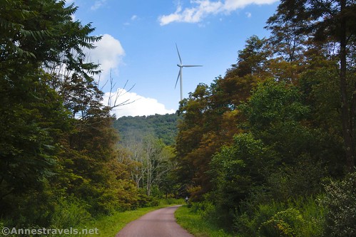
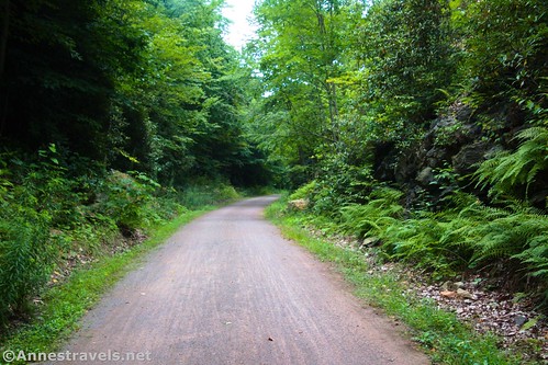
I found the next section to be a long, slow uphill through the trees. You do cross several roads (there’s also a small parking area – Sand Patch – 1.7 miles beyond Keystone Viaduct, or about Mile 28.2), but otherwise, it’s mostly just quiet forest riding. When you cross Warrens Mill Road, you may see signs for Amish baked goods – it’s not too far off the trail, and there are all kinds of treats, from fresh fruit and veggies to personal-sized snacks.
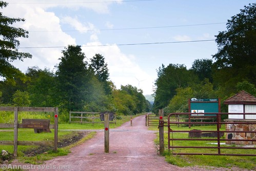
At Mile 24.6, you’ll come to the Deal Parking Area. This is another large lot with a primitive restroom and a couple of picnic tables – but no water. The Deal Parking is a popular place for people to begin their rides.

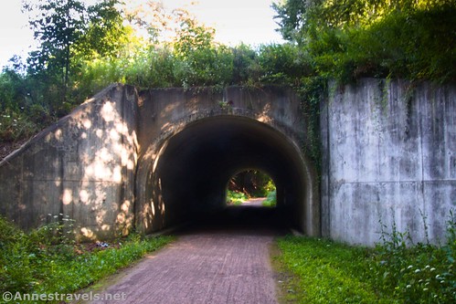
The scenery changes subtly after this. You’re going into the mountains, so there are hills around the path. Just under a mile from Deal Parking, you’ll come to the Eastern Continental Divide. This is really neat!

I especially liked the maps and lines inside the tunnel. It really illustrated the concept of the Eastern Continental Divide well – at least to my mind!
The best part? Now you’re going downhill! Yay! (Well, until you come back!) The Eastern Continental Divide is the high point of the GAP. But the excitement isn’t over – in fact, it’s just beginning.
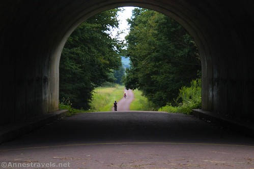
At Mile Marker 22.0 (about 1.7 miles beyond the Eastern Continental Divide), the path vanishes into a tunnel. Like, a long, dark hole in the mountainside, with open gates pushed back against the sides of the mountain. This is the type of thing mysteries and horror films are made of, but it turns out that the Big Savage Tunnel is totally legit!
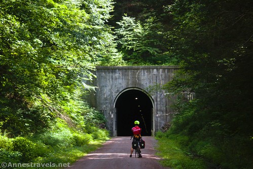
It’s also quite safe. Volunteers and local organizations had to work together to get it open for the GAP, and they make sure it stays safe for cyclists. I won’t guarantee you won’t get a “cave kiss” though – it’s pretty damp in there!
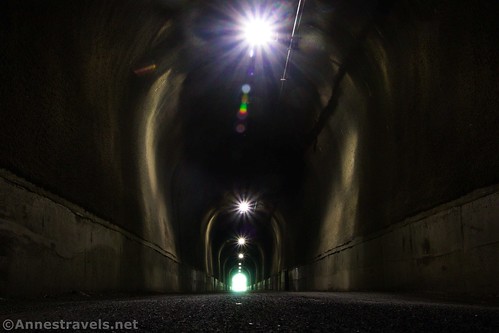
The tunnel is fairly well-lit – at least, there’s enough light to see what you’re doing. One or two lights were out when I went through, and those sections were dim. But I felt safe enough to stop and get some photos!

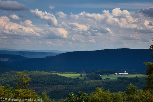
On the other side of the Big Savage Tunnel, the trail curves for 0.2 miles out to a kind of park in the middle of nowhere. There’s a nice view over the nearby valley, complete with benches, and a pavilion has picnic tables nearby. I don’t know why this is here, though there appears to also be a helicopter pad.
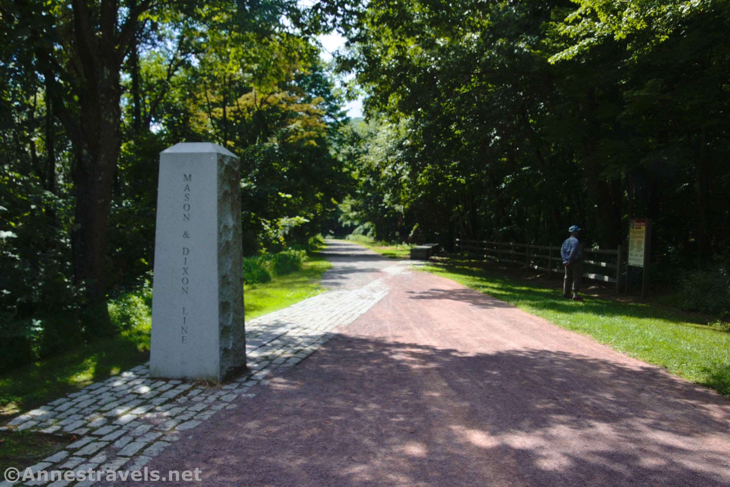
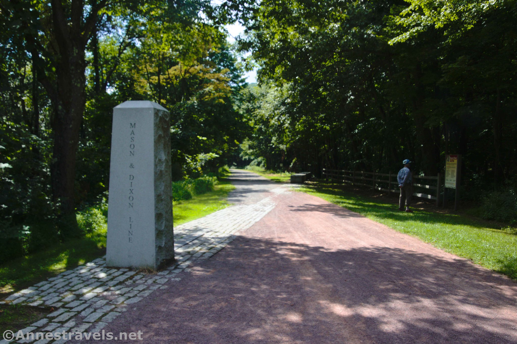
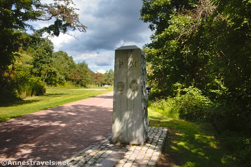
Continue down the trail for a final 1.2 miles to the monuments marking the Pennsylvania-Maryland state line. This is also the Mason-Dixon Line, so several signs explain the history of the line. It’s actually quite well done.
I could have gone further, but I would have had to ride 1.5 miles just to get to the next road… and it’s 1.1 miles beyond that to the Borden Tunnel (the next point of interest; it’s quite a bit shorter than the Big Savage Tunnel) (Frostburg is the next official parking, at Mile 15.5 – 2.2 miles beyond Borden Tunnel). I decided I was good on traveling south – at least for that day!

Round Trip Trail Lenth: My GPS tracked a total of 27.9 miles, but that included crossing the Salisbury Viaduct an extra 2 times (out & back). If you do what I described here, it should be about 27 miles RT.
Elevation Gain: 771ft. up, 538ft. down (2,021ft. to 2,720ft.)
Facilities: Restrooms, water, and services are available in Meyersdale. Restrooms are also available at the Deal Trailhead.
Fees: None

Trail Notes: The 4% grade is deceivingly difficult. Give yourself grace to slog along slower than you’d thought reasonable. Be sure to take plenty of water, as there’s very little available along the route. There is a speed limit of 15mph. Try to stay right and give an audible signal before you pass on the left. No alcohol is permitted. Stay on the trail, as most of the adjacent land is privately owned. The Great Allegheny Passage is open from dawn to dusk year-round, although the Big Savage Tunnel is closed from late November to early April and there is no posted detour. The Big Savage Tunnel is named for the mountain through which it travles, not for any specific event or person. The interactive map on the GAPTrail website is a great resource.

Trail 
Road ![]()
Signs
Scenery ![]()
![]()
Would I go 100 miles out of my way for this? ![]()
Overall Rating: ![]()

GPS Coordinates for the Great Allegheny Passage: Salisbury Viaduct to Maryland State Line
Viaduct Trailhead: 39.8310140°, -079.0397970° (39°49.86084′, -079°02.38782′ / 39°49’51.6504″, -079°02’23.2692″) (2,053ft.) (0.0)
East end of Salisbury Viaduct: 39.8320090°, -079.0417400° (39°49.92054′, -079°02.50440′ / 39°49’55.2324″, -079°02’30.2640″) (2,017ft.) (0.15)
Cemetery: 39.8353440°, -079.0474910° (39°50.12064′, -079°02.84946′ / 39°50’07.2384″, -079°02’50.9676″) (2,024ft.) (0.51)
Viaduct end: 39.8309690°, -079.0397910° (39°49.85814′, -079°02.38746′ / 39°49’51.4884″, -079°02’23.2476″) (2,053ft.) (1.13)
Deal Trailhead: 39.7612790°, -078.9314210° (39°45.67674′, -078°55.88526′ / 39°45’40.6044″, -078°55’53.1156″) (2,343ft.) (0.0)
Eastern Continental Divide: 39.7534630°, -078.9160640° (39°45.20778′, -078°54.96384′ / 39°45’12.4668″, -078°54’57.8304″) (2,402ft.) (0.99)
Big Savage Tunnel: 39.7455080°, -078.8965470° (39°44.73048′, -078°53.79282′ / 39°44’43.8288″, -078°53’47.5692″) (2,356ft.) (2.39)

Viewpoint: 39.7356400°, -078.8907350° (39°44.13840′, -078°53.44410′ / 39°44’08.3040″, -078°53’26.6460″) (2,326ft.) (2.58)
Mason-Dixon Line: 39.7229710°, -078.9016810° (39°43.37826′, -078°54.10086′ / 39°43’22.6956″, -078°54’06.0516″) (2,242ft.) (3.78)
Return to Deal: 39.7612710°, -078.9314430° (39°45.67626′, -078°55.88658′ / 39°45’40.5756″, -078°55’53.1948″) (2,342ft.) (8.00)
Warrens Mill Road: 39.7793100°, -078.9566620° (39°46.75860′, -078°57.39972′ / 39°46’45.5160″, -078°57’23.9832″) (2,281ft.) (9.91)
Sand Parking: 39.7955430°, -078.9754150° (39°47.73258′, -078°58.52490′ / 39°47’43.9548″, -078°58’31.4940″) (2,237ft.) (11.60)
Keystone Viaduct: 39.8104400°, -078.9955260° (39°48.62640′, -078°59.73156′ / 39°48’37.5840″, -078°59’43.8936″) (2,133ft.) (13.27)
Bollman Bridge: 39.8184390°, -078.9948350° (39°49.10634′, -078°59.69010′ / 39°49’06.3804″, -078°59’41.4060″) (2,156ft.) (13.88)
Meyersdale: 39.8166670°, -079.0213790° (39°49.00002′, -079°01.28274′ / 39°49’00.0012″, -079°01’16.9644″) (2,110ft.) (15.45)
End Deal Trailhead: 39.7612870°, -078.9314380° (39°45.67722′, -078°55.88628′ / 39°45’40.6332″, -078°55’53.1768″) (2,342ft.) (22.83)
Meyersdale Trailhead: 39.8167330°, -079.0213640° (39°49.00398′, -079°01.28184′ / 39°49’00.2388″, -079°01’16.9104″) (2,113ft.) (0.0)
Salisbury Viaduct: 39.8319860°, -079.0417890° (39°49.91916′, -079°02.50734′ / 39°49’55.1496″, -079°02’30.4404″) (2,016ft.) (1.59)
West end of viaduct: 39.8352220°, -079.0473680° (39°50.11332′, -079°02.84208′ / 39°50’06.7992″, -079°02’50.5248″) (2,025ft.) (2.00)
End in Meyersdale: 39.8166630°, -079.0214240° (39°48.99978′, -079°01.28544′ / 39°48’59.9868″, -079°01’17.1264″) (2,108ft.) (4.00)
The gpx files for 4 different rides on the Great Allegheny Passage can be downloaded – please note that this and the GPS Coordinates are for reference only and should not be used as a sole resource when hiking this trail.
Johnny Popper Road TH & Salisbury Viaduct
Download GPX File size: 12.7 KB Downloaded 341 times
Deal TH to Mason-Dixon Line/Maryland State Line
Download GPX File size: 43.3 KB Downloaded 352 times
Deal TH to Mason-Dixon Line & Meyersdale
Download GPX File size: 106.3 KB Downloaded 351 times
Meyersdale TH to Salisbury Viaduct
Download GPX File size: 25.1 KB Downloaded 355 times
(Note: I do my best to ensure that all downloads, the webpage, etc. are virus-free and accurate; however, I cannot be held responsible for any damage that might result, including but not limited to loss of data, damages to hardware, harm to users, from use of files, information, etc. from this website. Thanks!)

Getting to the Salisbury Viaduct Trailhead
From I-68, take Exit 22 for US-219N toward Meyersdale PA. At the traffic circle, take the third exit onto US-219; at the second traffic circle, take the first exit to stay on US-219. About 12.9 miles later, take the exit toward Garrett. Turn left onto US-219 BUS S for 0.3 miles, then turn left onto Johnny Popper Road. Stay on Johnny Popper Road for about a quarter mile; turn right into the gravel lot.

From I-76, take Exit 110 toward Somerset & US-219. Turn onto E Main Street for 0.3 miles, then take a slight right to continue onto Berlin Plank Road (Plank Road) for 2.0 miles. Turn right to merge onto US-219S for 0.4 miles. Merge again onto US-219S and drive 9.3 miles. Take the exit for Meyersdale/Garrett. After 0.4 miles, turn left onto US-219BUS S for 0.7 miles. Turn left onto Johnny Popper Road. Stay on Johnny Popper Road for about a quarter mile; turn right into the gravel lot.
Getting to the Meyersdale Parking
From I-68, take Exit 22 for US-219N toward Meyersdale PA. At the traffic circle, take the third exit onto US-219; at the second traffic circle, take the first exit to stay on US-219. About 9.5 miles later, take the exit for US-219 BUS toward Meyersdale. Turn right onto US-219 BUS N for 1.2 miles, then take a slight right onto Meyers Avenue. After 0.2 miles, turn left onto Cherry Street and then take an almost immediate right onto Main Street. Only 0.1 miles later, turn left into the visitor center parking lot.

From I-76, take Exit 110 toward Somerset & US-219. Turn onto E Main Street for 0.3 miles, then take a slight right to continue onto Berlin Plank Road (Plank Road) for 2.0 miles. Turn right to merge onto US-219S for 0.4 miles. Merge again onto US-219S and drive 9.3 miles. Take the exit for Meyersdale/Garrett. After 0.4 miles, turn left onto US-219BUS S for 2.3 miles. Turn left onto Main Street; 0.4 miles later, turn left into the visitor center parking lot.

Getting to the Deal Parking
From I-68, take Exit 29 onto MD-546. Drive north for 3.3 miles (plus 0.2 miles; the road changes names after entering Pennsylvania). Turn right onto McKenzie Hollow Road for 3.2 miles, then turn left onto Deal Road for 0.5 miles. Turn right into the gravel parking lot.
From I-76, take Exit 110 toward Somerset & US-219. Continue straight for about 0.9 miles; turn left onto E Main Street for 0.3 miles, then take a slight right to continue onto Berlin Plank Road (Plank Road) for 8.1 miles. The road will change names to Broadway Street; continue another 0.3 miles. Turn left onto Main Street for 0.4 miles, then turn right onto S. Cumberland Street for 11.9 miles. Turn right onto Mckenzie Hollow Road. After 0.9 miles, turn right onto Deal Road for 0.5 miles. The gravel parking area will be on the right.
Today’s Featured Product!
You’ll enjoy this guide to the Great Allegheny Passage. True stories, history, and more are tucked alongside useful maps and information. Buy your copy here!

More Related Posts:
 Beautiful Keuka Outlet Trail!
 Genesee Valley Greenway – Oakland to Letchworth
 40 Miles on the Cuyahoga Valley Ohio & Erie Canal Path!
 How to Visit the Deception Pass Bridge for Free
 Genesee Valley Greenway-Lehigh Valley Trail Loop in Rochester!
 Driving the Fayette Station Road & Views of the New River Gorge Bridge