
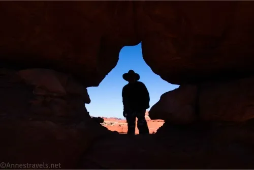
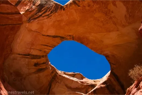
I put off visiting Paul Bunyan’s Potty for many years. (And if you’re wondering what in the world I’m talking about, the “potty” is an arch along the Horse Canyon Road in the Needles District of Canyonlands National Park, Utah.) It seemed like a long, slow, sandy slog along a 4×4 road. And that would be true. But when I found myself almost at the end of the Peek-a-boo Trail much earlier in the day than I had expected, we decided to take a little side journey to see Paul Bunyan’s Potty over in Horse Canyon, too. It was a crazy fun experience and might have included a few frozen puddles along the way.
Quick Stats
This post may contain affiliate links. I earn a small commission if you click a link with which I’m an affiliate. There is never an extra cost for you.

I ended up making the trail into a loop: Wooden Shoe (Squaw) Canyon to Lost Canyon to Peek-a-boo Trail to the Lower Salt Creek Canyon Road to Horse Canyon, then up Horse Canyon to Paul Bunyan’s Potty, then back down Horse Canyon and the Lower Salt Creek Canyon Road to the road to Cave Spring. After that, we walked along the road to the main park road, along the main park road to the campground road, and back to the Wooden Shoe Canyon Parking Area. The entire loop (with the spur to the arch) ended up being exactly 16 miles. If we’d been thinking ahead, we’d have left our bikes at the beginning of the Lower Salt Creek Road (the gate; after this, you’d need a permit to drive or bike up the road) and cut 4 miles of road walking off our trek. But our plans developed over time, so we walked all those miles!
My dad wrote a poem to commemorate our trek (to the tune of “Low Bridge Everybody Down”):
Rose this morning,
Sun was pale.
Sixteen miles on
The Peek a Boo Trail.
Water’s slushy,
Bread was stale.
Sixteen miles on
The Peek a Boo Trail.
Low arch everybody crawled
Low arch ‘specialy if you’re tall.
Can always tell your family,
Bout your weary tale.
Sixteen miles on
The Peek a Boo Trail.
Wish y’had boat,
Wish y’had a rail.
Sixteen miles on
The Peek a Boo Trail.
We’ll finish this hike
Without fail.
Sixteen miles on
The Peek a Boo Trail.
Rocks so red,
Sky’s so blue.
Sixteen miles
With an epic view.
Low arch everybody crawled
Low arch ‘specialy if you’re tall.
Can always tell your family,
Bout your weary tale.
Sixteen miles on
The Peek a Boo Trail.
If you’re doing the traditional route to Paul Bunyon’s Potty, park at the Lower Salt Creek Trailhead (there is space for a few cars without blocking the gate). Note that you can drive from here to the Paul Bunyan’s Potty Trailhead with a stock 4×4 vehicle; permits are available at Recreation.gov beginning at 8am on the day before your adventure – if the permits do not sell out, you can pick one up at the visitor center on the day of your trip (see the latest information on permits here). Walk (or drive or ride your bike if you have a permit) up the road for about 3.3 miles, turning left when Horse Canyon splits from the Lower Salt Creek Canyon Road about mile 2.25.
I didn’t do it the traditional way, so I’ll describe what I did below.
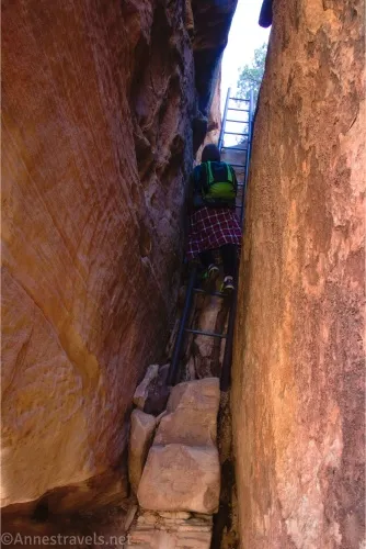
0.0 Wooden Shoe Canyon Trailhead (5,121ft.). Follow the route for the Peek-a-boo Trail until you descend the tall ladder beyond Peek-a-boo Window. (38.143498°, -109.803702°)
0.0 Long Ladder (5,113ft). At the bottom of the ladder (I believe it has 12 rungs), the trail will pop out from a kind of rock cave to turn sharply right to go along the cliff face on your right and brush on your left. Instead of turning right with the trail, continue straight off-trail down into a wash. Turn left to follow the wash down to where it meets the road. (For a slightly longer hike, you could follow the trail all the way to Trail Arch and then go down the road, so there would be no off-trail portion of this hike. But it would add a fair bit of mileage, and since all but one of us had seen Trail Arch the year before, we decided to forgo the option and just go off-trail to cut down to the road). (38.117712°, -109.755548°)
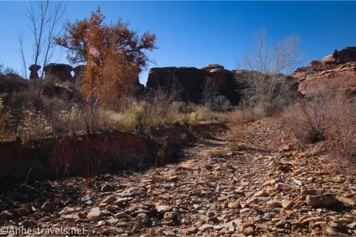
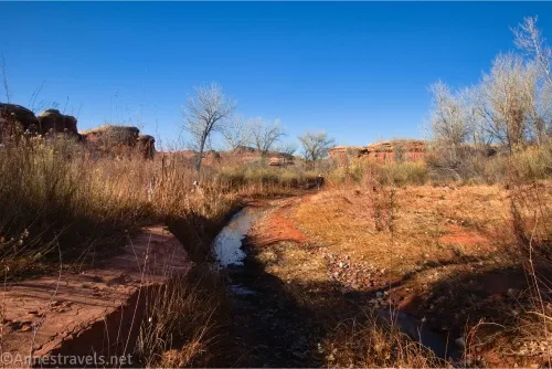
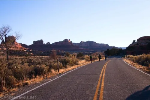
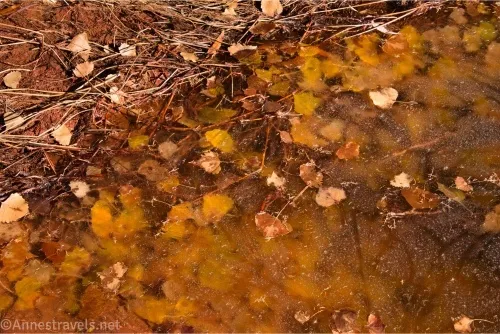
5.6 Meet Lower Salt Creek Canyon Road (5,006ft.). Turn left here to walk down the road. I visited on a frigid November day (hey, the sun was warm!). There were many deep potholes and flooded sections of the road (maybe that’s why the NPS wasn’t issuing permits for the road at that point?), and the water was mostly frozen. It didn’t make me feel warmer! The road passes through stands of trees/brush and passes rock formations as it makes its way down to a major road junction. (38.1170040°, -109.7539470°)
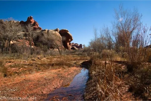
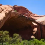
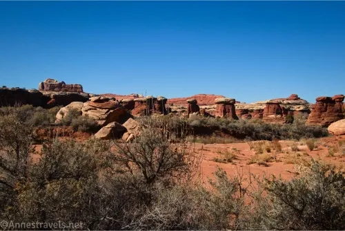
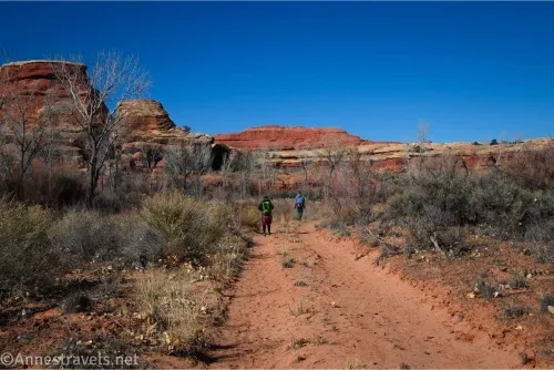
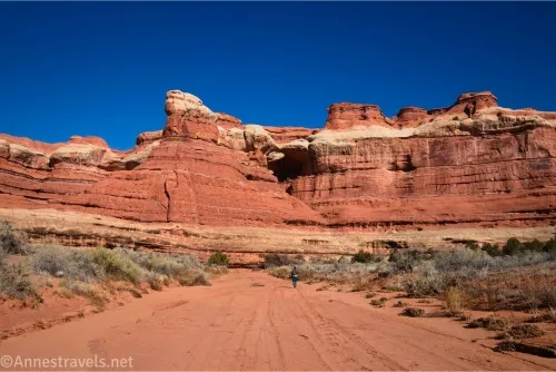
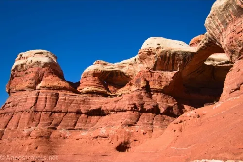
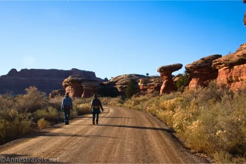
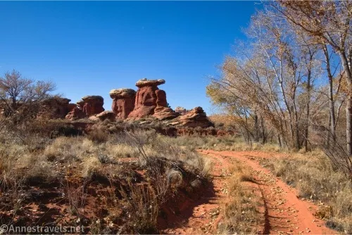
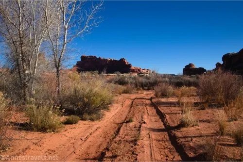
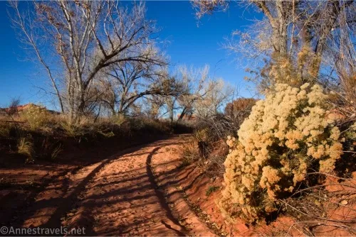
6.5 Horse Canyon Junction (4,975ft.). The road splits in a Y here; it is marked with a small sign. Turn right to go up Horse Canyon (which was open for 4x4ers, not that I saw anyone!) The route is sandy and would be very warm on a hot day. But because my day was so cold, we were able to enjoy the many rock formations along the canyon as we hiked up the road. At times, hikers’ trails cut the goosenecks in the wash/road (the road mostly follows the wash). These are definitely worth following; you just need to be careful not to take the hiker’s trail that bypasses Paul Bunyan’s Potty. (38.1259880°, -109.7491360°)
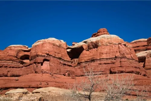
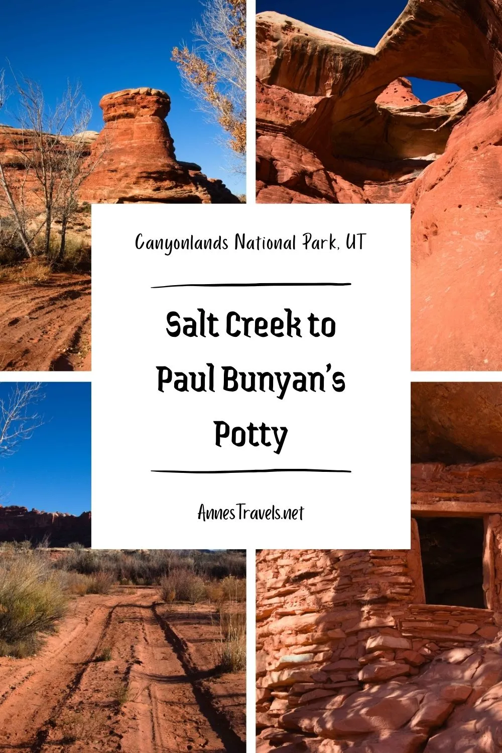
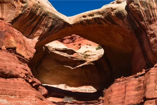
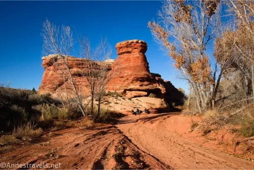
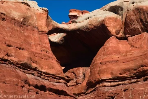
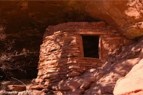
7.0 Skull Arch View (aka Mrs. Bunyan’s Potty) (5,020ft.). The arch is high in the cliffs on the left. It’s easy to miss. As you continue to walk and the road passes directly below cliffs on the left, keep your eyes open for a small granary in an alcove – when you see this, you know you’re getting close. (38.1217850°, -109.7449580°)
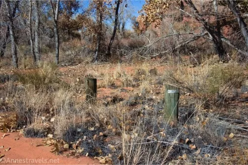
7.6 Paul Bunyan’s Potty Road Junction (5,036ft.). The road is unassuming on the left, and while I believe it’s marked, the sign is not especially obvious. Turn left up this short access road to the trailhead. (38.1188350°, -109.7390560°)
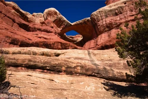
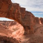
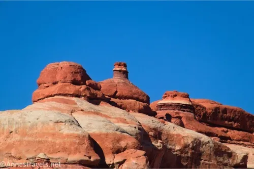
7.65 Paul Bunyan’s Potty Trailhead (5,041ft.). The arch is visible from here, so there’s no need to go closer. But of course, I followed the trail to see it better! (38.1186580°, -109.7382930°)
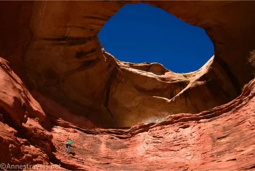
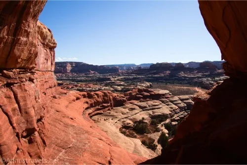
7.7 Paul Bunyan’s Potty Viewpoint (5,046ft.). Enjoy the views from here. Or if you’re me, walk over to the right to ascend onto a shelf that you can walk along to get beneath the arch. Do NOT try to scramble the watercourse up to stand directly beneath the arch – besides the watercourse being extremely steep and a bit slippery (this coming from someone who doesn’t mind Class 4 climbs), it’s illegal to enter the alcove beneath the arch due to several old or possibly newer granary ruins. When you’ve finished exploring, retrace your steps back to the Horse Canyon Junction. (Note: You can continue up Horse Canyon about a mile to the access road for Tower Ruin. I would have loved to do this, but it just wasn’t going to work with the amount of daylight we had to work with.) (38.1191960°, -109.7380320°)
9.75 Horse Canyon Junction (4,975ft.). Turn right to continue downcanyon. There are a fair number of rock formations as well as stands of cottonwood trees. Be wary of quicksand after rain – the year before, some of my group had hiked part of Salt Creek and had met some park employees trying to extricate one of the park trucks from quicksand! At times, a hiker’s trail parallels the road – this can ease hiking muscles considerably. (38.1259880°, -109.7491360°)
12.1 Lower Salt Creek Canyon Road Gate (4,931ft.). Walk around the gate. You could have left a shuttle vehicle or bicycles here without the need for a permit. We had not, so we continued to walk down the gravel road. (38.149646,-109.754909)
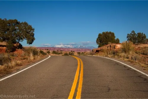
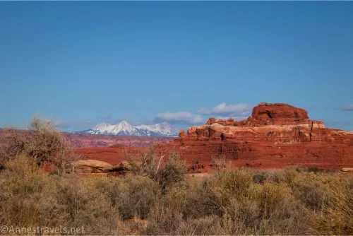
13.3 Lower Salt Creek Road/Cave Spring Road Junction (4,957ft.). Turn left. Views are excellent behind you to the La Sal Mountains and various rock formations. Actually, there are quite a few nice views along this road. Pass by the Wooden Shoe Group Camp on your right. (38.1538180°, -109.7681470°)
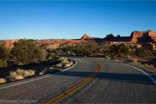
14.7 Needles Park Road (Main Park Road) Junction (5,080ft.). Turn left. Be wary of vehicles, as there isn’t much shoulder. Thankfully, most people drive slowly to enjoy the views, and they’re very likely to give you extra space. (38.1475850°, -109.7872120°)
15.0 Campground Road (5,072ft.). Turn left here. The road winds its way to, and then through Loop A of the campground. (38.1494370°, -109.7920300°)
16.0 Wooden Shoe Canyon Trailhead (5,121ft.). Congratulations, you made it! (38.143498°, -109.803702°)

Round Trip Trail Length: 8.7-16.0 miles out & back or loop
Elevation Gain: 1,955ft. (4,917ft. to 5,342ft.)
Facilities: Campground and restrooms at the Wooden Shoe Trailhead. Otherwise none.
Fees: $30/vehicle, valid 7 days. America the Beautiful National Parks and Federal Public Lands Passes and Southeastern Utah Parks Annual Passes are accepted.
Trail Notes: I was not exactly in shape for a 16 mile hike, and one of my group members was six months out from major surgery, but none of us felt it was an extremely difficult hike. In fact, we would have said those 16 miles felt more like 10. This is probably due to the fact that most of the hike was fairly flat (except when going straight up or down slickrock). It still would have been nicer to bike or drive the roadwalk! You do not need a special permit unless you plan to bike or drive beyond the gate on Lower Salt Creek Canyon Road/Horse Canyon. This is not a good hike for a warm day, as the heat gets trapped in the canyon. The tread can be sandy, so expect to exert more effort than you might think. Be sure to keep your eyes open in the canyon for rock formations, arches, ruins, and more!
Trail 
![]()
![]()
Road ![]()
Signs ![]()
Scenery
Would I go 100 miles out of my way for this?
Overall Rating: ![]()
GPS Coordinates for My Route from the Peek-a-boo Trail to Paul Bunyan’s Potty and Lower Salt Creek Road
Leave trail: 38.1175030°, -109.7554780° (38°07.05018′, -109°45.32868′ / 38°07’03.0108″, -109°45’19.7208″) (5,064ft.) (5.37)
Meet road: 38.1170040°, -109.7539470° (38°07.02024′, -109°45.23682′ / 38°07’01.2144″, -109°45’14.2092″) (5,006ft.) (5.59)
Skull Arch View (aka Mrs. Bunyan’s Potty): 38.1217850°, -109.7449580° (38°07.30710′, -109°44.69748′ / 38°07’18.4260″, -109°44’41.8488″) (5,020ft.) (6.97)
Paul Bunyan’s Potty Road Junction: 38.1188350°, -109.7390560° (38°07.13010′, -109°44.34336′ / 38°07’07.8060″, -109°44’20.6016″) (5,036ft.) (7.59)

Paul Bunyan’s Potty Trailhead: 38.1186580°, -109.7382930° (38°07.11948′, -109°44.29758′ / 38°07’07.1688″, -109°44’17.8548″) (5,041ft.) (7.65)
Paul Bunyan’s Potty Viewpoint: 38.1191960°, -109.7380320° (38°07.15176′, -109°44.28192′ / 38°07’09.1056″, -109°44’16.9152″) (5,046ft.) (7.70)
Horse Canyon Road Junction: 38.1259880°, -109.7491360° (38°07.55928′, -109°44.94816′ / 38°07’33.5568″, -109°44’56.8896″) (4,975ft.) (9.73)
Gate: 38.1496460°, -109.7549090° (38°08.97876′, -109°45.29454′ / 38°08’58.7256″, -109°45’17.6724″) (4,931ft.) (12.08)
Squaw Flat Road/Cave Spring Road Junction: 38.1538180°, -109.7681470° (38°09.22908′, -109°46.08882′ / 38°09’13.7448″, -109°46’05.3292″) (4,957ft.) (13.35)
Squaw Flat Road/Needles Road Junction: 38.1475850°, -109.7872120° (38°08.85510′, -109°47.23272′ / 38°08’51.3060″, -109°47’13.9632″) (5,080ft.) (14.66)

Needles Road/Campground Road Junction: 38.1494370°, -109.7920300° (38°08.96622′, -109°47.52180′ / 38°08’57.9732″, -109°47’31.3080″) (5,072ft.) (15.00)
End at Big Spring Canyon/Squaw Canyon Trailhead: 38.1434600°, -109.8036730° (38°08.60760′, -109°48.22038′ / 38°08’36.4560″, -109°48’13.2228″) (5,129ft.) (16.00)
The gpx file for my loop on the Peek-a-boo Trail, Paul Bunyan’s Potty, and Lower Salt Creek can be downloaded – please note that this and the GPS Coordinates are for reference only and should not be used as a sole resource when hiking this trail.
Download GPX File size: 230.0 KB Downloaded 183 times
(Note: I do my best to ensure that all downloads, the webpage, etc. are virus-free and accurate; however, I cannot be held responsible for any damage that might result, including but not limited to loss of data, damages to hardware, harm to users, from use of files, information, etc. from this website. Thanks!)
Getting to the Wooden Shoe Flat Trailhead
From the Needles District Visitor Center, turn right back out on the main road (if you come to the entrance station, you’ve gone the wrong way). After 2.8 miles, turn right following the sign for Campground and Elephant Hill. Pass by the road on the right to the B Loop of the Campground and Elephant Hill, and continue on the paved road to a long but narrow parking lot on the left about 0.9 miles after your last turn. (If you miss this, you’ll very quickly come to the loop at the end of the road, so not much is lost!)
If you’re trying to get to the Lower Salt Creek Trailhead, from the Needles District Visitor Center, turn right out onto the main road. After 0.7 miles, take a left toward Ranger Residence, Salt Creek, and Cave Spring. Drive another 0.7 miles, then turn left onto a dirt/gravel road (this road is suitable for low-clearance vehicles), following the arrows toward Cave Spring and Salt Creek. After 0.8 miles, turn right onto another gravel road that will take you to the gate for the Salt Creek Road/Trail.
Note that it’s almost exactly a 2 hour drive from Moab to the Needles. It’s a little shorter from Monticello. Thankfully, the drive is very pretty!

Find the Trails the Guides Gloss Over
Check out my favorite book about Canyonlands National Park – because instead of just mentioning the famous trails, it gets down into the best, most beautiful, and explorative routes, as well! It also has fun and interesting history and good maps. Buy your copy here.