
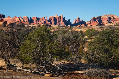
This week, I’m going to share with you one of my all-time favorite trails in Canyonlands National Park. While Elephant Hill and Chesler Park is my first choice for “best,” the Peek-a-boo Trail (also in the Needles District) comes in as a close second. The first is a blow-your-mind kind of hike (nothing else quite like it in the world). But Peek-a-boo is simply beautiful. With rock formations, a cool arch, canyon views, and miles of hiking with views to the La Sal Mountains, it’s just a real treat all the way around!
Quick Stats
Note: Some of the links in this post are affiliate links. If you click one and purchase something, I may earn a small commission without an extra cost to you.

I’ve hiked the Peek-a-boo Trail twice – once in late October and again the next year in mid-November. I was a little worried the second time that I’d hyped it too much in my mind. After all, October meant we had fresh snow on the La Sal Mountains and colorful yellow quaking aspens in the canyons (not to mention some orange scrub oaks). But I shouldn’t have wasted the mental energy. It’s still lovely even without the benefits of autumn (that said, don’t try this on a very hot day; there is little shade, and the sun reflecting off of the slickrock is hot!)
Note that, while it’s a pretty simple trail, it isn’t exactly a stroll in the park. There are quite a few trail junctions; then there are significant sections of slickrock scramble and at least one unavoidable ladder bolted into the slickrock. There’s also a second taller ladder that you’ll need to descend to get to the lower portion of the trail, but you don’t have to do that section unless you want to see the rock art and final arch. So all that to say that you’ll want to be ready for an adventure before hiking the Peek-a-boo Trail!

The trail begins at the end of the A loop of the Needles (Squaw Flat) Campground. Take the trail between the fenceposts to the informational sign. Almost immediately after this, the trail splits with Big Spring Canyon turning right and everything else turning left. Turn left.

I’m guessing the signs say Wooden Shoe Canyon (I hear reports that the signs have been replaced), but all of my photos (from both years) say Squaw Canyon because that was its name up until this year or maybe late last year. I won’t go into the politics here, but suffice to say that at least 50% of Americans can’t figure this one out – why the need for the change or what the issue is with the term. Maybe the 10-20% that really care are happy.

Then there are people like me who are descended from the tribe from which the term “squaw” was borrowed to indicate a female of native decent – it was an honor to have flats, canyons, arches, points, peaks, and more named after these strong, hard-working women who were often matriarchs of their tribes. The PC police can take away cultural heritage and honor, but at least they can’t take away personal identity. Ok, I’ll stop ranting now. Just realize that you may see maps, signs, and more with either “Squaw Canyon” or “Wooden Shoe Canyon.” It’s the same thing.

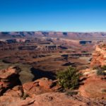
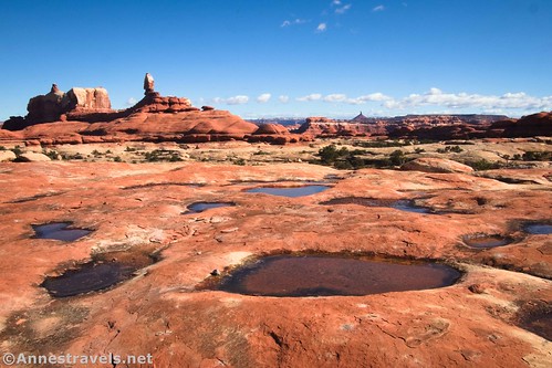
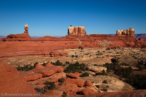
The trail passes across the grasslands (which old topos call Squaw Flat), occasionally crossing slickrock and/or small gullies. Follow the cairns. Be sure to look back at the Needles, which rise at the other side of the flat.
After 1.1 miles, you’ll drop into the wash that (if you turned upstream) would quickly turn into Wooden Shoe (Squaw) Canyon. Instead, you want to turn left on the Lost Canyon Trail.

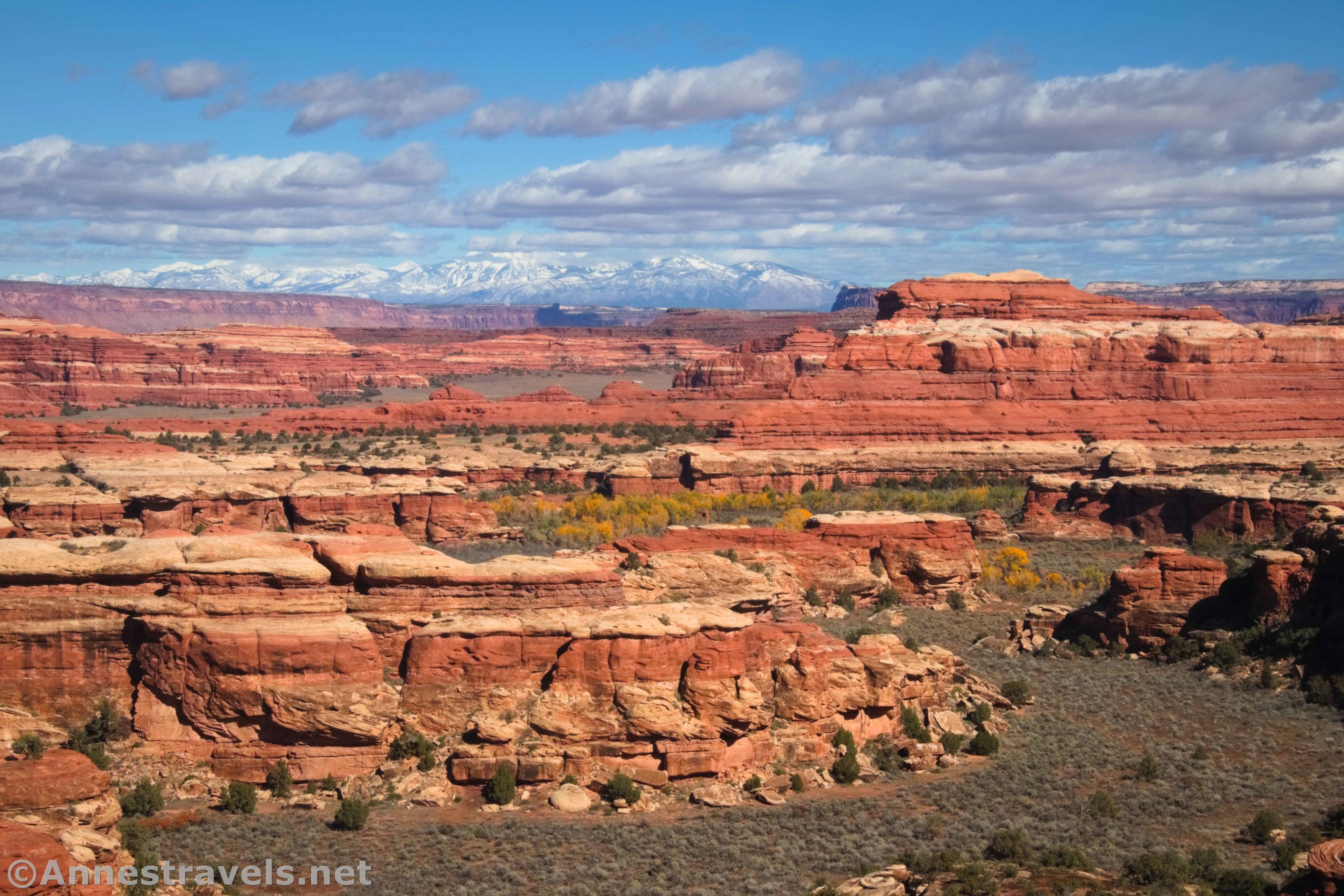
This is where life begins to get exciting. Views are still excellent to the Needles and also northwest to Island in the Sky and Junction Butte.

The trail takes you to the base of a slickrock bench which you’ll need to scramble up to get to the saddle between Wooden Shoe Canyon and Lost Canyon. It’s not terribly difficult; just steep Class 2 or mild Class 3 depending on your route. The views from the saddle are spectacular.

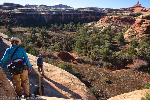
From the saddle, the trail makes its way left along the side of the bench. Watch your feet and you should be fine. Follow the cairns as they lead down to the white layer of rock and eventually to the top of a ladder about a mile beyond where you left Wooden Shoe (Squaw) Canyon.

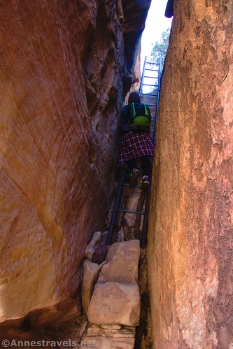
The ladder is great fun. Getting your feet over the first rung is the hardest part, then it’s a simple matter of climbing down about six or eight feet (so sayeth someone who isn’t too afraid of heights!) Two of my group members are not very fond of either ladders or heights, but we got them down with some reassurance and maneuvering their feet into the right places. They could probably have done it themselves, but having us helped it go faster.
The trail from here continues along the side of the bench and drops down into a side wash off of the main branch of Lost Canyon. Follow the wash down to the next junction in Lost Canyon proper (pay attention to where you enter and exit the wash, as you’ll need this information when you come back).

Almost 2.8 miles from the parking area, arrive at another trail junction. The sign is (was) marked as Lost Canyon. The sign said that Squaw Flat Campground went both ways (the way you came and straight up Lost Canyon) and the Peek-a-boo Trail turns left. (Translated: You can get back to the trailhead either way. To complete Lost Canyon, you’d want to go straight (the longer way back to the trailhead that goes up the main wash).
On our first visit, we hemmed and hawed here. We were trying to decide if we wanted to take the Peek-a-boo Trail or complete Lost Canyon and then hike the Wooden Shoe Canyon/Big Spring Canyon loop. I’m so glad we turned left and did Peek-a-boo!
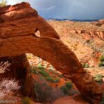
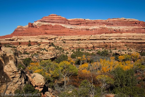
The trail fairly quickly comes to the canyon wall; you’ll need to scramble up the watercourse. This is the most difficult scrambling on the entire trail per me. It’s definitely steep Class 2 with a few Class 3 moves. As you climb, make sure to look back at Wooden Shoe Arch – in the autumn and winter, this is a much better view than the official Wooden Shoe Arch Overlook along the road (which shows the shadowed north face of the arch).

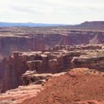
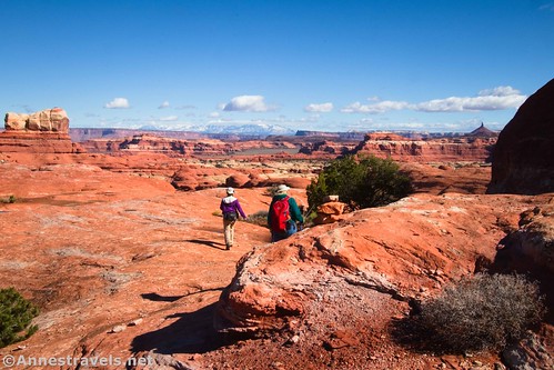
Less than half a mile beyond the Lost Canyon junction, the route suddenly crests the top of the red slickrock bench. What views await! Congratulations; you’ve arrived at the best part of the hike!

If you want the shortest hike possible, turn left out onto the nearby red rock promontory for an approximately 6-6.5 mile hike. We did this to find a nice place to eat an early lunch (first lunch? Meals get weird out on the trail!)

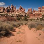
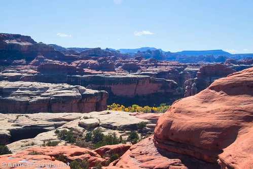
The Peek-a-boo Trail continues along the red bench. I liken it to a ridge hike in that there isn’t much elevation gain, but you get fantastic views of the La Sal Mountains and Lost Canyon, not to mention nearby rocks and rock formations. There’s an unnamed formation that you can see for most of this section of the hike. It changes shape as you go along – we decided it was everything from a milk jug to a sea captain to an angry chicken!
Because the bench follows the rim of the canyon, there the path meanders around the side canyons. At one point, the trail rises to pass over a higher bench. But since you’re sort of stuck between the cliffs and the canyon, it’s hard to get too lost!
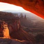
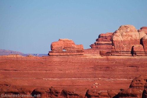
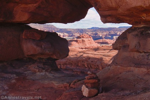
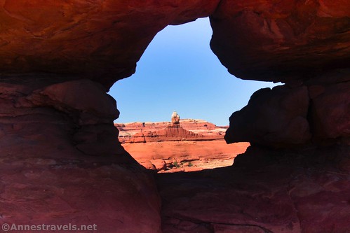
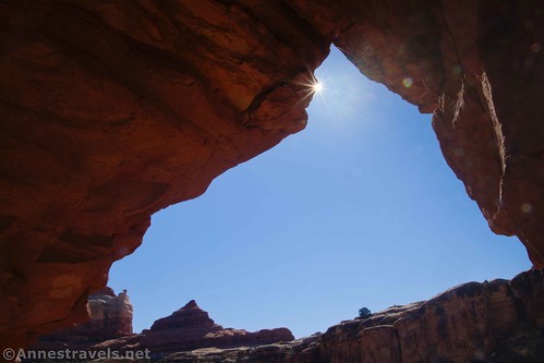
About 4.8 miles from the trailhead, you’ll come to what I call Peek-a-boo Window. It sneaks up on you; you’re just trotting along the bench, and suddenly there’s the coolest-shaped arch on your right. I’m not sure where the official trail goes, but I do know that you can either walk around the end of the fin and come back or else go through the window (my preference, of course!)
The second time I visited, I met a couple at the window who told me that they’d had to turn around here due to ice on their last visit – apparently, the slickrock beyond this is north-facing. So if it’s snowy or icy, it doesn’t melt very quickly. They were quite happy to be able to do it this year!
The slickrock after this is a little more angled than before, but my group did just fine. The views are also more open, with great vistas down on Salt Creek Canyon as well as out to the Six Shooter and other features.

Within about a quarter mile, the trail begins descending off the slickrock via a slickrock slope at the end of a fin. You’ve now seen the best the Peek-a-boo Trail has to offer. So if you just don’t feel like some extra elevation gain or more adventures, feel free to turn around here for an approximately 10 mile hike.

But if you want to finish it off, continue down the slickrock. About 0.7 miles beyond the window, you’ll come to the final ladder. This is another fun adventure, as the 12-rung ladder descends a very narrow crack in the rock, and getting over the first rung can be a little gnarly. Thankfully, my group member who doesn’t like heights, ladders, or tight spaces had opted to stay up at the top of the descent – the thought of trying to coach her down this is not one I relish! I’ve heard that those with large packs may need to lower the backpacks down with a rope.

At the bottom of the ladder, take a sigh of relief and turn right to follow the dusty trail. Or at least, that’s what we did on our first visit. On our second visit, we decided to skip the rock art and Trail Arch. We also decided to skip hiking back up the Peek-a-boo Trail and instead dropped down to the Lower Salt Creek Canyon Road. From there, we hiked down the road to the Horse Canyon turnoff, hiked up Horse Canyon, and finally enjoyed Paul Bunyan’s Potty (a pothole arch). By hiking back down Lower Salt Creek Canyon Road to the Cave Spring Road, and then walking the shoulder of the park roads back to the trailhead, we racked up a total of 16 miles! Given how much we hadn’t hiked on that trip, and the lack of daylight hours in November, I’d call that quite an accomplishment!
But we’re talking about the Peek-a-boo Trail in this guide, so I’ll just have to come back to that other trek another day. The Peek-a-boo Trail works its way down below the cliffs to the area below the towering white rock formations. It’s further than it looks, and hiking on slickrock is definitely easier than hiking on a dusty, crumbly trail.

But you do have a reward. Only 0.3 miles beyond the ladder (it felt like it was at least double that!), you’ll come to a trail junction, some nice rock art, and Trail Arch. It’s pretty cool, per me.
I scrambled down to the camping area (call it professional interest) about a tenth of a mile below the arch. The campsites are available through recreation.gov. No one seemed to be staying there either time I visited – but then again, the road to the campsites wasn’t open on either visit. And given the error message I received when I went to the website, I’d say they aren’t planning to reopen the road any time in the near future (the Horse Canyon spur is often open, assuming the road isn’t full of quicksand like it was on my first visit…)

From here, it’s a simple matter of retracing your steps. But the good news is that you get to see all those fantastic views on your way back, too!

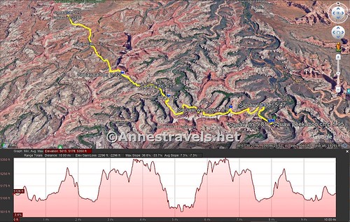
Round Trip Trail Length: I racked up 11.4 miles. The least you can get away with and still get the great views is 6 miles RT. To the window and back is 9.6 miles.
Elevation gain: 2,296ft. (5,015ft. to 5,350ft.)
Facilities: Pit toilets at the trailhead (flush toilets are available in the campground on your way to the trailhead). Campground available at the trailhead (park in your site if you stay there to ease parking congestion); primitive campground available near Trail Arch. (Note that both campgrounds tend to sell out very quickly, so get your site months in advance if possible.)
Fees: $30/vehicle, valid 7 days. America the Beautiful National Federal Lands Passes and Southeast Utah Parks Annual Passes are honored.

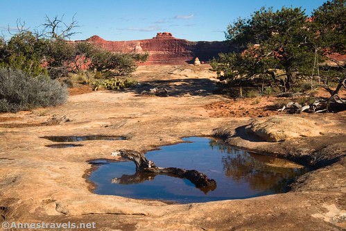
Trail Notes: I hear this trail can be icy in winter. I have found this trail to be less taxing than many other trails of a similar length, but it still isn’t easy. Be prepared for adventure. After a rain, potholes in the slickrock fill with water for some fun photography options. Keep your eyes open for other arches and fun rock formations along the way – you never know what you might find!

Trail 
![]()
![]()
![]()
Road ![]()
Signs
Scenery
Would I go 100 miles out of my way for this?
Overall Rating: ![]()

GPS Coordinates for the Peek-a-boo Trail
Wooden Shoe (Squaw) Canyon TH: 38.143498,-109.803702 (38°08.60988′, -109°48.22212′ / 38°08’36.5928″, -109°48’13.3272″) (5,121ft.) (0.0)
Wooden Shoe (Squaw) Canyon/Big Spring Canyon Junction: 38.142996,-109.803680 (38°08.57976′, -109°48.22080′ / 38°08’34.7856″, -109°48’13.2480″) (5,124ft.) (228ft.)
Wooden Shoe (Squaw) Canyon/Lost Canyon Junction: 38.132765,-109.794895 (38°07.96590′, -109°47.69370′ / 38°07’57.9540″, -109°47’41.6220″) (5,107ft.) (1.13)
Ladder: 38.124735,-109.785632 (38°07.48410′, -109°47.13792′ / 38°07’29.0460″, -109°47’08.2752″) (5,201ft.) (2.12)
Lost Canyon/Peek-a-boo Trail Junction: 38.121698,-109.777330 (38°07.30188′, -109°46.63980′ / 38°07’18.1128″, -109°46’38.3880″) (5,116ft.) (2.77)
La Sal Viewpoint: 38.119376,-109.775049 (38°07.16256′, -109°46.50294′ / 38°07’09.7536″, -109°46’30.1764″) (5,280ft.) (3.21)
Peek-a-boo Window: 38.116831,-109.762494 (38°07.00986′, -109°45.74964′ / 38°07’00.5916″, -109°45’44.9784″) (5,347ft.) (4.79)
Ladder: 38.117712,-109.755548 (38°07.06272′, -109°45.33288′ / 38°07’03.7632″, -109°45’19.9728″) (5,113ft.) (5.47)
Trail Junction: 38.114619,-109.755098 (38°06.87714′, -109°45.30588′ / 38°06’52.6284″, -109°45’18.3528″) (5,077ft.) (5.81)

Rock Art: 38.114548,-109.755119 (38°06.87288′, -109°45.30714′ / 38°06’52.3728″, -109°45’18.4284″) (5,091ft.) (5.82)
Arch: 38.114410,-109.755024 (38°06.86460′, -109°45.30144′ / 38°06’51.8760″, -109°45’18.0864″) (5,094ft.) (5.85)
Peek-a-boo Camp: 38.114642,-109.754535 (38°06.87852′, -109°45.27210′ / 38°06’52.7112″, -109°45’16.3260″) (5,044ft.) (5.95)
End: 38.143461,-109.803725 (38°08.60766′, -109°48.22350′ / 38°08’36.4596″, -109°48’13.4100″) (5,121ft.) (11.43)

The gpx file for the Peek-a-boo Trail can be downloaded – please note that this and the GPS Coordinates are for reference only and should not be used as a sole resource when hiking this trail.
Download GPX File size: 230.7 KB Downloaded 391 times
(Note: I do my best to ensure that all downloads, the webpage, etc. are virus-free and accurate; however, I cannot be held responsible for any damage that might result, including but not limited to loss of data, damages to hardware, harm to users, from use of files, information, etc. from this website. Thanks!)
Getting to the Peek-a-boo Trailhead (Needles Campground Loop A)
From the Needles District Visitor Center, turn right back out on the main road (if you come to the entrance station, you’ve gone the wrong way). After 2.8 miles, turn right following the sign for Campground and Elephant Hill. Pass by the road on the right to the B Loop of the Campground and Elephant Hill and continue on the paved road to a long but narrow parking lot on the left about 0.9 miles after your last turn. (If you miss this, you’ll very quickly come to the loop at the end of the road, so not much is lost!)
Note that it’s almost exactly a 2 hour drive from Moab to the Needles. It’s a little shorter from Monticello. Thankfully, the drive in is very pretty!
This Week’s Featured Product!
While I’m talking about one of my favorite trails in Canyonlands, I might as well introduce you to one of my favorite guidebooks to the region! It’s the most comprehensive book I know of on the market in terms of trails and dirt roads, not to mention excellent maps, trail write-ups, and history vignettes. Buy your copy here!