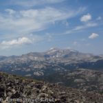
The Dad’s Lake Trail is a gem of a day hike in the Wind River Range of Wyoming. Yes, it’s long (I went almost 18 miles that day – you don’t have to hike quite that far). No, it’s not easy. Yes, you’ll hike through a lot of forest. Yes, you’ll also see gorgeous meadows, several lovely lakes, and views galore. And yes, it’s is most definitely worth the effort!
Quick Stats
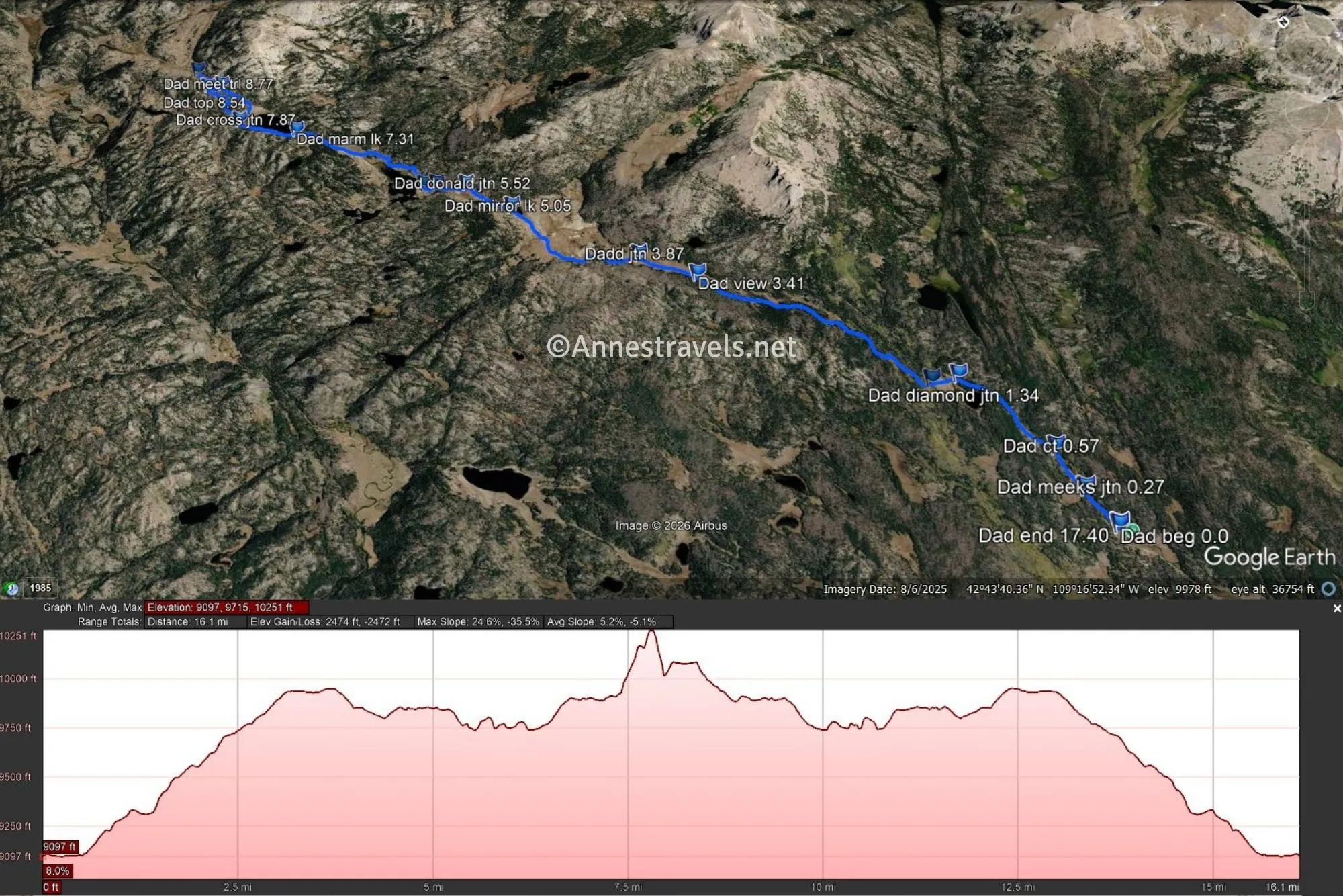
The minimum mileage for this hike would be around 6.8 miles (out & back to the meadows) or 10.0 miles to the first lake (Mirror Lake, and it definitely lives up to its name). I went to Dad’s Lake (11.7 miles RT), then Marm’s Lake (14.6 miles RT), then did a crazy off-trail hike up a mountain (don’t recommend), and then to the first view in a meadow beyond Marm’s Lake (well worth the extra mileage) which ended me at a total of 17.4 miles for a day hike. Yikes!
But as I said, every footstep was worth it, and I hope you can see a little bit about the trail from my photos!
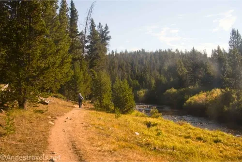
0.0 Big Sandy Lake Trailhead (9,096ft.). This is the same trailhead as for the Cirque of Towers (which we would hike the next day… 17.4 miles and then another 19 miles the next day as two dayhikes… we were beat!) Most people who leave from here are backpackers or dayhikers to Big Sandy Lake. The trail is broad as it marches through the forest beside Big Sandy Creek. (42.6883440°, -109.2707850°)
0.25 Meeks Lake Junction (9,095ft.). Continue straight (right) to cross a meadow with a few nice views, and then reenter the forest to continue along Big Sandy Creek. (42.6919170°, -109.2690870°)
0.6 Continental Divide Trail (9,104ft.). Turn left here to leave Big Sandy Creek and the route to the Cirque of Towers behind. The path is still through the forest, only now it’s heading uphill. (42.6956360°, -109.2666600°)
1.3 Diamond Lake Junction (9,314ft.). Take the left fork here in the meadow to reenter the forest again. A short but steep climb takes you to the next junction. (42.7065620°, -109.2689090°)
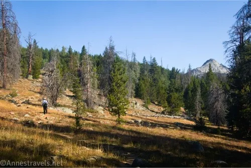
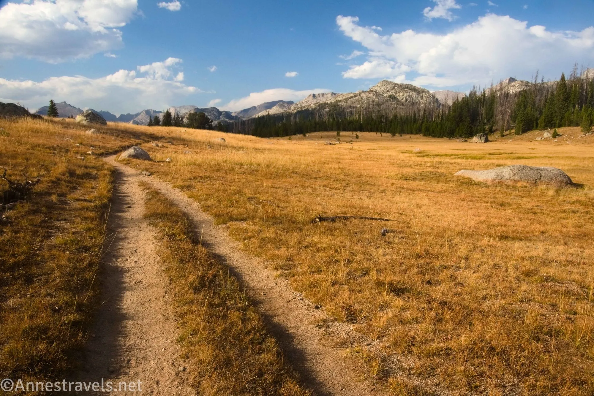
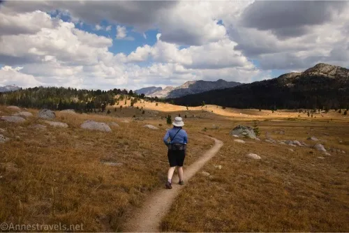
1.5 Fremont Trail Junction (9,342ft.). Turn right toward Dad’s Lake – there is one more push up to where the trail suddenly pops out of the trees into meadows – congratulations, the view part of the hike has officially begun! (42.7065620°, -109.2689090°)
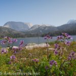
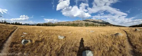
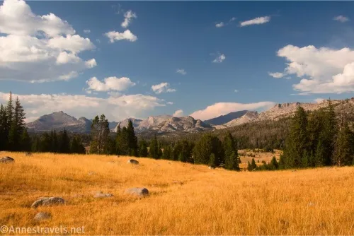
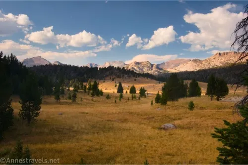
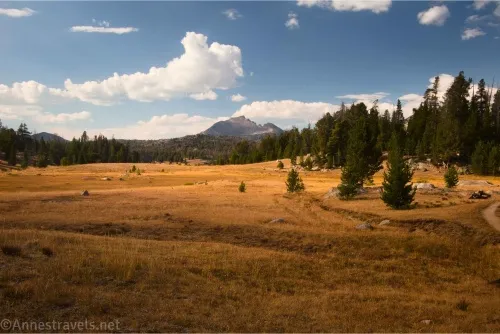
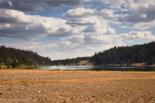
3.4 Meadows (9,936ft.). This is the first good turnaround point. The trail meanders through the meadow; note that maps may be wrong in this section because the trail has been rerouted to be less in the meadow and more along the treeline beside the meadow (boooo for views, yay for conservation). Views are spectacular of nearby mountains and meadows – but then again, I’m an official meadow-lover, so any hike with a meadow to views of mountains is the best! (42.7280470°, -109.2764080°)
4.3 Unmarked junction on left (9,852ft.). The junction is unmarked, but the path goes to Francis Lake. Keep walking as the path descends to lower meadows, rolling with the terrain. (42.738763°, -109.284976°)
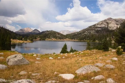
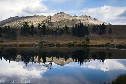
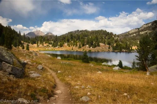
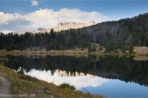
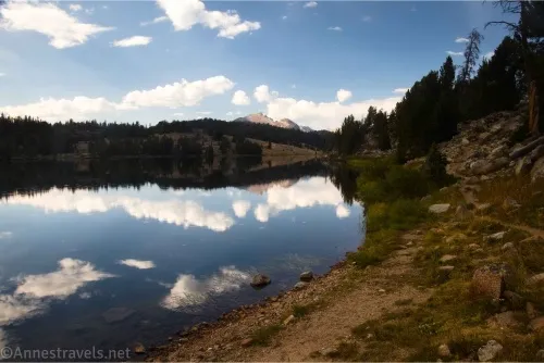
5.0 Mirror Lake (9,841ft). This is the second good turnaround point. When we passed by in the mid-morning, there was some amount of mirror in the water. On our way back, we knew how the lake had received its name – wow! Beyond the lake, the trail continues to roll on its way down to Dad’s Lake. (42.7469350°, -109.2836550°)
5.5 Donald Lake Junction (9,843ft.). Continue straight (right) toward Dad’s Lake. The path goes downhill – not really what I wanted, but it’s the terrain, so we ran with it! (42.7525330°, -109.2849090°)
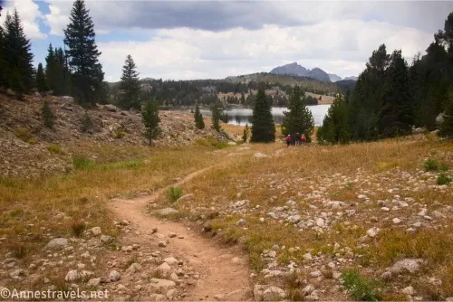
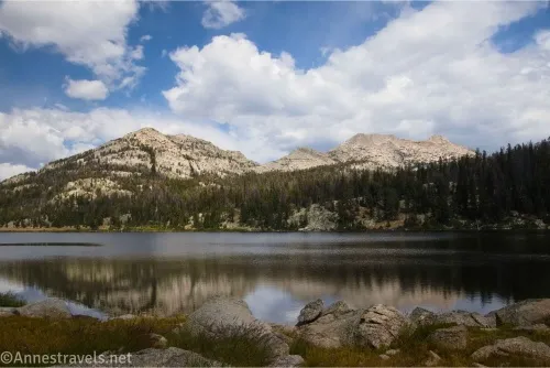
5.75 Unmarked Trail Junction (9,767ft.). The left trail goes to an overlook of Dad’s Lake, while the right trail goes along the shore of Dad’s Lake and is the route toward Marm’s Lake. We went left to a viewpoint (unofficial and unmarked) at the end of the lake. (42.7548800°, -109.2873380°)
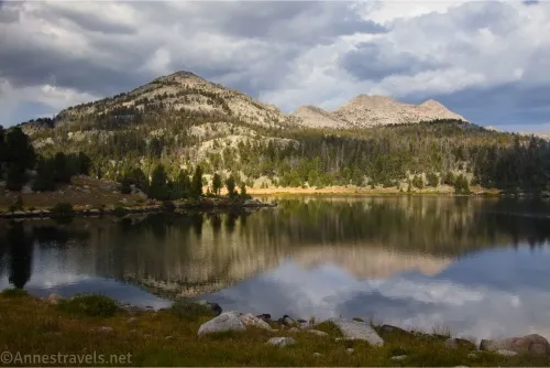
5.85 Dad’s Lake Viewpoint (9,761ft.). Enjoy the views over the lake. Unfortunately for us, about this point, the clouds rolled in, so we only had cloudy views of the lake (at least it didn’t rain too much on us!) After enjoying the view (and eating a first lunch if you’re us), go back to the trail junction and turn left to walk along the shore of Dad’s Lake. The path eventually turns away from the lake, but after crossing a stream, it will pass through meadows beyond the lake. The meadows look like they could be quite wet in the spring. The trail climbs from Dad’s Lake up toward Marm’s Lake. (42.7556710°, -109.2885130°)
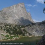
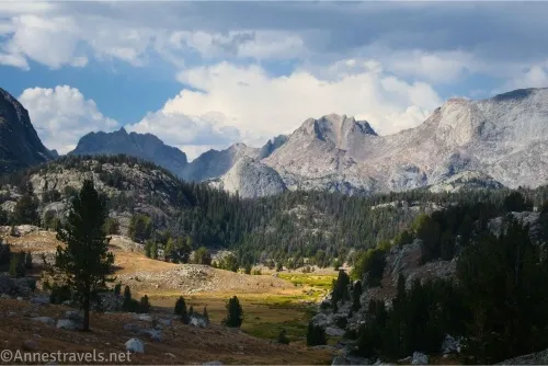
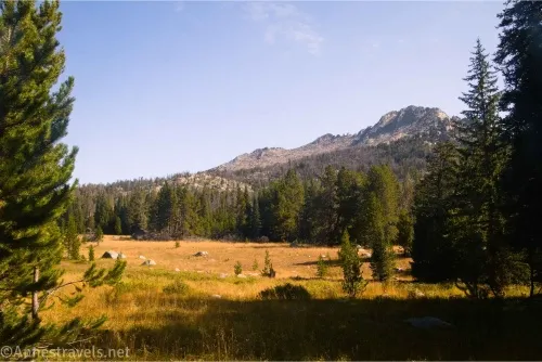
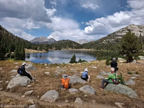
7.3 Marm’s Lake (9,906ft.). This is really as far as you should go on a day hike. The views are great, and the sun even came out again! However, I saw a mountain, and a hiker came up about this point, enthusing about the views from beyond the lake. Sooo… against our better judgment, we kept hiking. (42.7711320°, -109.2940540°)
7.9 Trail Junction (9,907ft.). Turn right(ish) toward Shadow Lake. What you should do is to stay on the trail. What I did was to eventually break left off the trail. I followed elk trails up a meadow, then turned right up the promising-looking mountain. More elk trails enabled me to get up to the ridgeline, then along the ridge in a rock scramble (all in trees, I might add) to the very end of the hill. I do not recommend this route at all. Besides being a pain, it’s much easier to get to this view by staying on the trail and then ascending a very steep but grassy hillside on the left (I’ll mark it below as where we came back to the trail). (42.7766740°, -109.2982300°)
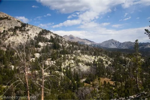
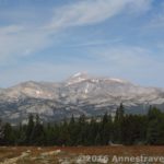
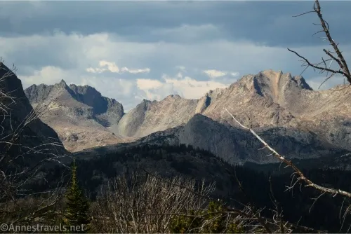
8.5 Top (end) of hill (10,251ft.). The views from the end of the hill were slightly obscured by dead trees, but they were pretty amazing. So while I don’t necessarily recommend going up on this hill at all, at least you get a good and unique view out of the deal! Enjoy the views before going back to the trail. Instead of retracing my steps, I headed in an almost straight line sideways and down a very steep grassy but forested slope directly back to the trail. (42.7830470°, -109.2976150°)
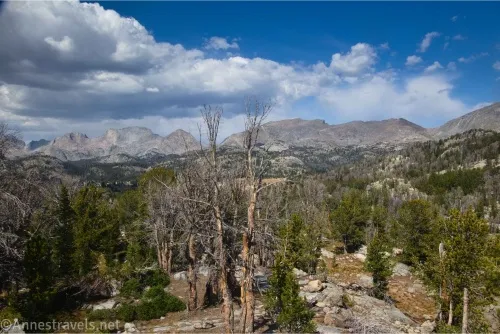
8.75 Meet the trail again (10,013ft.). Most of my group turned right to descend back down to Marm’s Lake. But I turned left up what appeared to be a short slope (but steep!) – I had to go a little beyond the rim of the slope, but the view! Wow! So worth the extra half mile or so (RT). (42.7829530°, -109.2956750°)
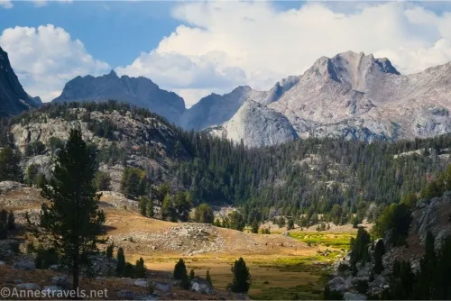
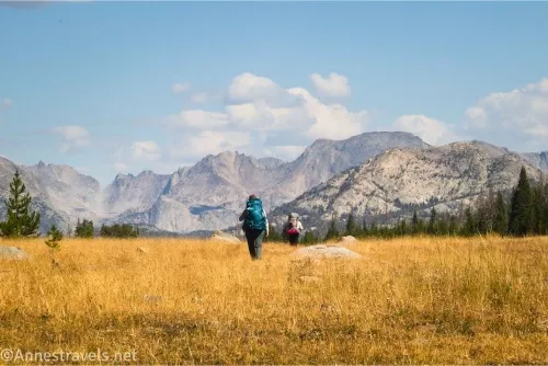
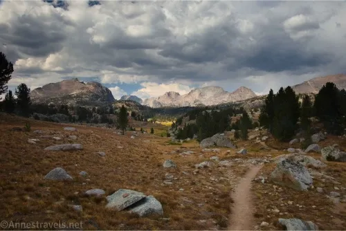
9.0 Turn around point (10,080ft.). This is where I turned around with fantastic views! You can see down into the valley with Washakie Creek and to the rugged peaks beyond (which you could also see from the end of the hill, but this is definitely a different perspective). We had to hurry to get back before dark (we didn’t make it), but the golden hour views were amazing all the way back through the meadows to the treeline! (42.7867510°, -109.2964120°)
Round Trip Trail Length: I went a total of 17.4 miles – as described above, you can make the hike shorter.
Elevation Gain: I went a total of 2,474ft. (9,097ft. to 10,251ft.)
Facilities: Primitive restrooms and a couple of picnic tables at the trailhead
Fees: None
Trail Notes: This is one long hike! The elevation gain is not significant, but it is significant enough to make the hike hard. Most people hike this as a backpacking trip, but be sure to follow all regulations (I came around a corner and crossed a stream to find a tent pitched well within 100ft. of both Dad’s Lake and the stream – don’t be Mr. Blue Tent!) Always filter your water, and pay attention to any signs telling you not to drink (even when filtered) some of the lakewater. As always, remember to leave no trace!
Trail 
![]()
![]()
Road ![]()
![]()
Signs ![]()
Scenery
Would I go 100 miles out of my way for this?
Overall Rating: ![]()
GPS Coordinates for Dad’s Lake and Marm’s Lake and Beyond
TH: 42.6883440°, -109.2707850° (42°41.30064’, -109°16.24710’ / 42°41’18.0384″, -109°16’14.8260″) (9,096ft.) (0.0)
Meeks junction: 42.6919170°, -109.2690870° (42°41.51502’, -109°16.14522’ / 42°41’30.9012″, -109°16’08.7132″) (9,095ft.) (0.27)
Continent Divide Trail: 42.6956360°, -109.2666600° (42°41.73816’, -109°15.99960’ / 42°41’44.2896″, -109°15’59.9760″) (9,104ft.) (0.57)
Diamond junction: 42.7053010°, -109.2661080° (42°42.31806’, -109°15.96648’ / 42°42’19.0836″, -109°15’57.9888″) (9,314ft.) (1.34)
Fremont junction: 42.7065620°, -109.2689090° (42°42.39372’, -109°16.13454’ / 42°42’23.6232″, -109°16’08.0724″) (9,342ft.) (1.54)
View: 42.7280470°, -109.2764080° (42°43.68282’, -109°16.58448’ / 42°43’40.9692″, -109°16’35.0688″) (9,936ft.) (3.41)
Junction: 42.7335060°, -109.2789420° (42°44.01036’, -109°16.73652’ / 42°44’00.6216″, -109°16’44.1912″) (9,944ft.) (3.87)
Mirror Lake: 42.7469350°, -109.2836550° (42°44.81610’, -109°17.01930’ / 42°44’48.9660″, -109°17’01.1580″) (9,841ft.) (5.05)
Donald junction: 42.7525330°, -109.2849090° (42°45.15198’, -109°17.09454’ / 42°45’09.1188″, -109°17’05.6724″) (9,843ft.) (5.52)
Junction: 42.7548800°, -109.2873380° (42°45.29280’, -109°17.24028’ / 42°45’17.5680″, -109°17’14.4168″) (9,767ft.) (5.75)
Dad’s Lake viewpoint: 42.7556710°, -109.2885130° (42°45.34026’, -109°17.31078’ / 42°45’20.4156″, -109°17’18.6468″) (9,761ft.) (5.85)
Marm’s Lake: 42.7711320°, -109.2940540° (42°46.26792’, -109°17.64324’ / 42°46’16.0752″, -109°17’38.5944″) (9,906ft.) (7.31)
Cross junction: 42.7766740°, -109.2982300° (42°46.60044’, -109°17.89380’ / 42°46’36.0264″, -109°17’53.6280″) (9,907ft.) (7.87)
Top of hill: 42.7830470°, -109.2976150° (42°46.98282’, -109°17.85690’ / 42°46’58.9692″, -109°17’51.4140″) (10,251ft.) (8.54)
Meet trail: 42.7829530°, -109.2956750° (42°46.97718’, -109°17.74050’ / 42°46’58.6308″, -109°17’44.4300″) (10,013ft.) (8.77)
Turn around: 42.7867510°, -109.2964120° (42°47.20506’, -109°17.78472’ / 42°47’12.3036″, -109°17’47.0832″) (10,080ft.) (9.05)
End: 42.6883740°, -109.2706960° (42°41.30244’, -109°16.24176’ / 42°41’18.1464″, -109°16’14.5056″) (9,099ft.) (17.40)
The gpx file for Dad’s Lake, Marms Lake, and all my adventures beyond can be downloaded – please note that this and the GPS Coordinates are for reference only and should not be used as a sole resource when hiking this trail.
Download GPX File size: 430.9 KB Downloaded 73 times
(Note: I do my best to ensure that all downloads, the webpage, etc. are virus-free and accurate; however, I cannot be held responsible for any damage that might result, including but not limited to loss of data, damages to hardware, harm to users, from use of files, information, etc. from this website. Thanks!)
Getting to the Dad’s Lake Trailhead (Big Sandy Opening)
From Pinedale, WY, take US-191 South for almost 12 miles to WY-353 E. This is next to the Boulder Store in the “town” of Boulder. Turn left onto WY-353 E and drive 15.5 miles; continue straight on Big Sandy / Elkhorn Road for an additional 11.8 miles. (The road turns to dirt somewhere in this area.) Not long after crossing the river, turn left, following the sign for Big Sandy Opening, onto Lander Cutoff Road. After 7.0 miles, turn left onto Big Sandy Opening Road (again following the signs for Big Sandy Opening). Stay on the main road to the Big Sandy Opening Trailhead a little over 10.5 miles later.
From I-80, take Exit 104 toward Rock Springs. Turn north on US-191 North and drive 38.5 miles. Turn right onto WY-28 E, following the signs for Lander. After 33.3 miles, turn left onto dirt Lander Cutoff Road for 24.8 miles. If ever in doubt about which road to take, stick with the main one; all the major intersections are signed (or at least should be!) Turn right onto Big Sandy Opening Road (signed) and arrive at the trailhead a little more than 10.5 miles later.
From Lander, head south on US-287 S for 9 miles; continue straight onto WY-28 W. After 33.1 miles, turn onto dirt Lander Cutoff Road, and follow the directions above (Rock Springs directions) to Big Sandy Opening Trailhead.
All the roads in this area are dirt. Taking the ones I’ve recommended, the roads are in quite good condition (the Big Sandy Opening Road has some potholes/rocks – and there’s always washboard – but considering the number of low clearance vehicles at the trailhead, it can’t be too bad). However, GPSes don’t necessarily take good roads vs. bad roads into consideration – ours consistently told us to turn on the California Trail, which is just a single track heading out across the scrubland with an occasional fence across it, as well as a number of two-sandy-tracks-in-the-sagebrush roads. Don’t be deceived – stick with the main, well-maintained roads!
My Guide to The Best Trails in Wyoming
I put some of my favorite off-the-beaten-path hikes in Wyoming into this book – and you can rest assured that they all have great views! (There are some famous hikes, too, as well as several trails that criss-cross the Wind River Range.) Buy your copy here!