
I read about Corkscrew Canyon on the internet. There was an old mining area, they promised, and a slot canyon. There was no trail, but it was pretty easy to walk up an old road. Alas, more research told me that the old road was actually private property and the old mining area and slot canyon were inaccessible via the road. Undaunted, we set out to see what we could find in Corkscrew Canyon without going onto private land.
Quick Stats
Note: Some of the links in this post are affiliate links. If you click one and purchase something, I may earn a small commission without an extra cost to you.
Note: Most of the National Park Service employees I talked with were oblivious to the private property in this part of the park. I’m not blaming them per se; there seem to be many pockets of private property within the park boundary that almost no one knows about. But be aware on this trek that there is private property and to the best of my knowledge I’ll tell you how to avoid it. At any rate, obey signs that may pop up when you’re least expecting it (why am I thinking of Wiley Coyote right now???)
As of fall 2024, it seems the park has acquired the property, and the signs have been removed. But, like Wile E. Coyote, you still might want to keep your eyes open for signs that pop up when you’re least expecting them…
We started where the Corkscrew Wash enters the Furnace Creek Wash along CA-190. It’s fairly easy to pull over on the shoulder of the road here as long as not too many people do it at once. One other group pulled in after us, though I suspect that Corkscrew Canyon wasn’t their destination since I didn’t see them while we were hiking.

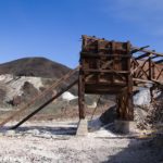
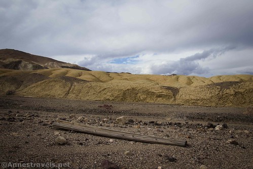
Not too far up the wash are some mining relics from another era. There’s not much left except for some old wood – I expect it’s been hit with a few flash floods over the years.

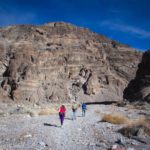
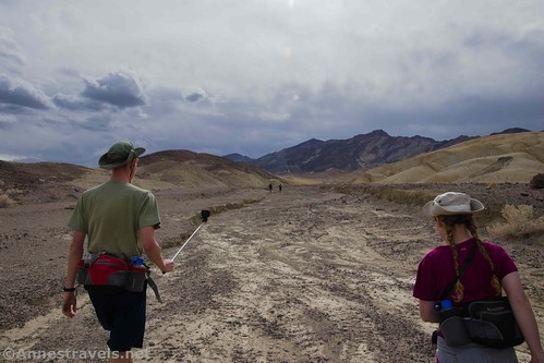
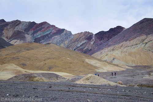
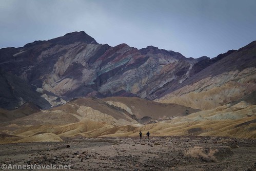
Hike up the very wide, gravely wash, turning left with the wash after eight tenths of a mile. Views are pretty good back toward the Funeral Mountains on the other side of the Furnace Creek Wash.
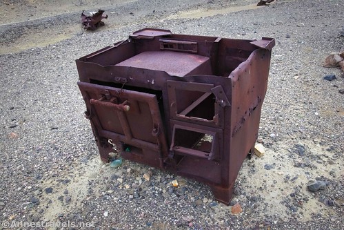
About mile 1.9, the wash turns sharply south to parallel an old mining road. The road is private property, so stay in the wash. Near where the wash turns south, there are quite a few old rusting pieces of junk including an old stove.
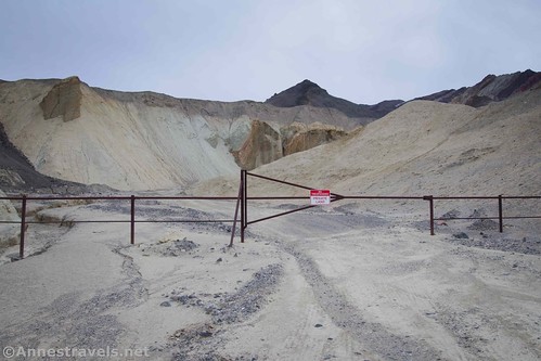
Keep walking up the wash as the walls become closer. About mile 1.9, the wash more or less ends in multiple smaller washes. If you scramble left, you’ll come to a gate with a sign that says, “Private Property.” Sadly, you can’t go any further up the road, which means no old mining stuff and no slot canyon. (FYI – the mine site is not just around the corner, despite what it looks like. It’s actually on the other side of the hills altogether.)
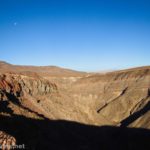
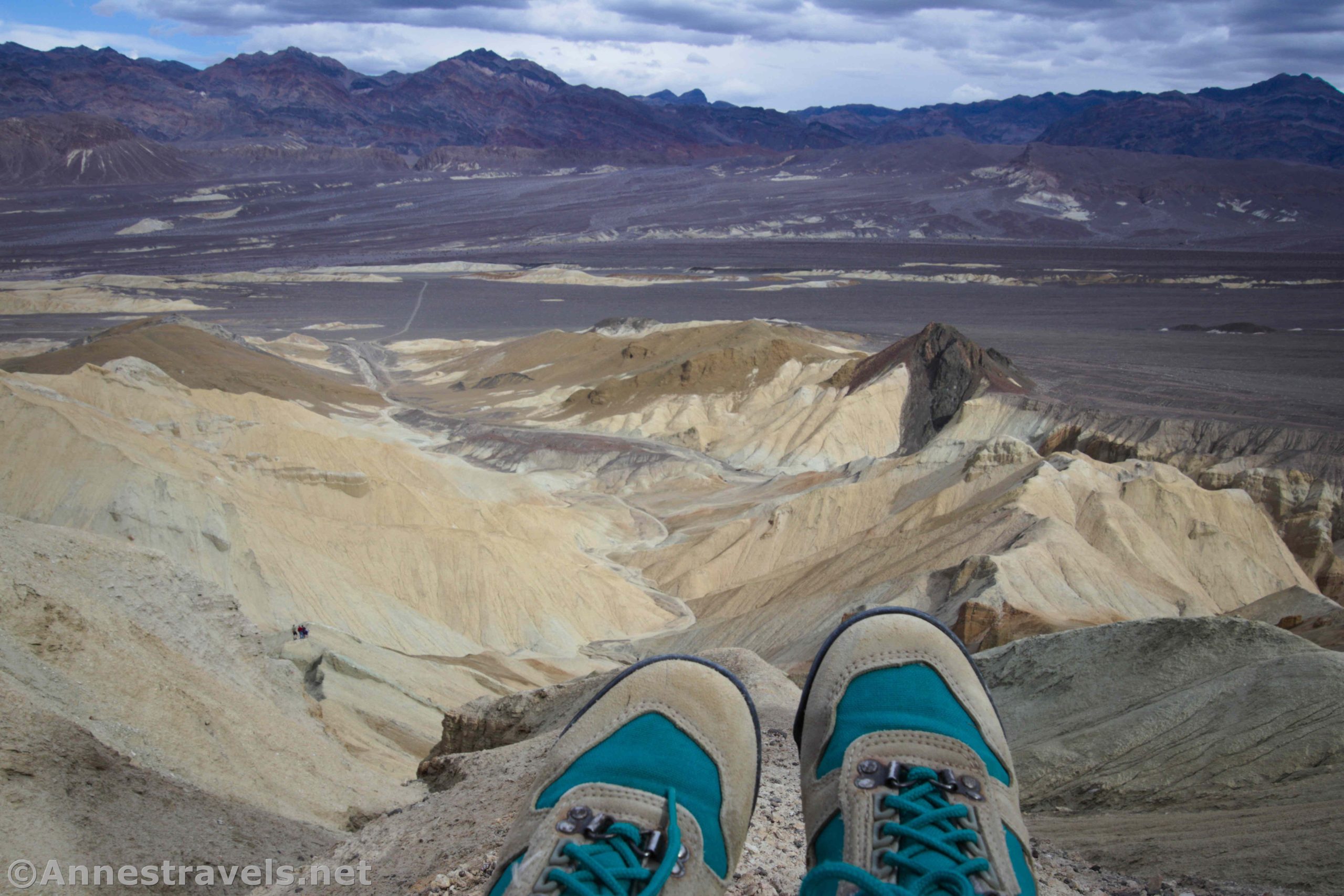
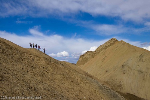
From here, I decided we hadn’t made this hike worthwhile. So I scrambled up the hillside, staying to the right of the metal posts (possibly the edge of the private property). The views from the hillside are quite good!
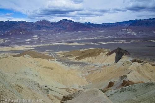
Some of my group scrambled all of the way up into the top of 20 Mule Team Canyon. From here, you could do a loop down through 20 Mule Team, though that would be a much longer hike if you didn’t have a shuttle vehicle.
So overall, Corkscrew Canyon was a bit of a disappointment. There really wasn’t that much to see. Still, it gave us something to do on a cloudy afternoon when we were all tired but wanted to not just sit around… I guess there’s some usefulness in that.

Round Trip Trail Length: 3.8 miles out & back
Elevation Gain: 553ft. out & back without scrambling up the hillside; scrambling up, it’s about 1,046ft. elevation gain
Facilities: None
Fees: $30/vehicle, valid 7 days. National Public Lands Passes and Death Valley Annual Passes are accepted.

Trail Notes: There isn’t much of a trail, but it’s pretty hard to get lost. The bottom of the wash is firm enough to make hiking at least reasonable. As I said above, there is unmarked (and sometimes marked) private property along this route, so try to stay on public land if possible. Don’t touch or move any of the historic junk along the way – and remember to Leave No Trace!

Trail 
![]()
![]()
![]()
Road
Signs ![]()
![]()
![]()
![]()
Scenery ![]()
![]()
Would I go 100 miles out of my way for this? ![]()
![]()
![]()
Overall Rating: 
![]()
![]()
GPS Coordinates for Corkscrew Canyon
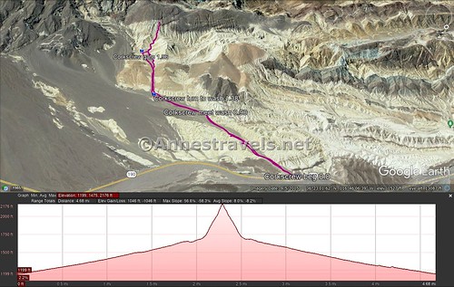
Beginning: 36.3963333°, -116.7673667° (N36° 23.780′ W116° 46.042′ / 36°23’46.8000″, -116°46’02.5200″) (1,144ft.) (0.0)
Meet Wash: 36.3844333°, -116.7643667° (N36° 23.066′ W116° 45.862′ / 36°23’03.9600″, -116°45’51.7200″) (1,354ft.) (0.90)
Turn Up Wash: 36.3787500°, -116.7602333° (N36° 22.725′ W116° 45.614′ / 36°22’43.5000″, -116°45’36.8400″) (1,480ft.) (1.38)
Gate: 36.3714167°, -116.7633833° (N36° 22.285′ W116° 45.803′ / 36°22’17.1000″, -116°45’48.1800″) (1,640ft.) (1.96)
End: 36.3963000°, -116.7674167° (N36° 23.778′ W116° 46.045′ / 36°23’46.6800″, -116°46’02.7000″) (1,184ft.) (5.00)

The gpx file for Corkscrew Canyon can be downloaded – please note that this and the GPS Coordinates are for reference only and should not be used as a sole resource when hiking this trail.
Download GPX File size: 81.4 KB Downloaded 370 times
(Note: I do my best to ensure that all downloads, the webpage, etc. are virus-free and accurate; however, I cannot be held responsible for any damage that might result, including but not limited to loss of data, damages to hardware, harm to users, from use of files, information, etc. from this website. Thanks!)

Getting to Corkscrew Canyon
From the Furnace Creek Visitor Center, turn right (south) onto CA-190E. Drive 7.8 miles to where a wash enters from the right. The wash is about 6.5 miles east of the Badwater Road and 0.2 miles east of the exit to the 20 Mule Team Scenic Drive. (If you’re coming from the east (Las Vegas, etc.) the wash is about 4.2 miles west of the road to Dante’s View.) Park out of the way of traffic along the shoulder of the road.
This Week’s Featured Product!
Explore beyond the tourist attractions with this guide to Death Valley National Park. With sand dunes, canyons, old mining communities, and more, there’s a lot of history, maps, and more in this book. Buy your copy here!