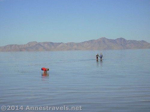
“When we were young”…wading in the Great Salt Lake
This week, I was going through some old files on my computer and ran across a document with some of my siblings’ compositions we’d written for school in the early 2000s. This document contained several reviews of parks we’d recently visited on a family vacation. As I recall, we planned to publish these on the now-debunked website “e-pinions”. I don’t think we ever published them, but it was fun to read through the reviews and see how our writing has all improved since then!
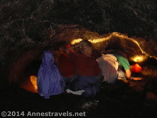
Caving in Craters of the Moon
Here they are…with minimal editing (would you believe that I spelled “area” as “aria”?). Now you know what four tweens (with nicknames) thought were worth visiting! And as you can see, we were into the lesser-known parks even back then!
City of Rocks National Reserve by “The Purple Pansy”
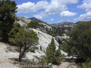
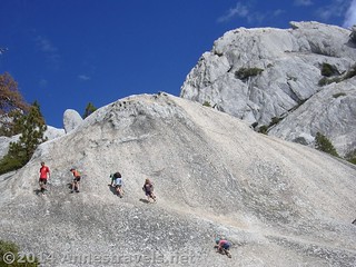
Hiking in the City of Rocks National Reserve
There’s tons of rocks to climb and lots of trails to hike as well as camping.
Pros: Climbing
Cons: Little shade. Poorly marked trails.
City of the Rocks is best known for rock climbing with ropes and equipment, but it is also good for children who like heights, climbing, and hiking.
When we went, we had fun hiking and climbing (without ropes). We hiked a few of the trails, but we also managed to get slightly lost because of the lack of trail signs. Thankfully, we were able to find our way back to the place where we had parked our vehicle. There are plenty of boulders around to climb on. Children love to climb on the rocks. There is a visitor center where you can get information about the park. We watched a video in the visitor center. Later, we even saw a Hawaii license plate!
When hiking, take food and water. Rest often. Watch children (especially young children) carefully. There are drop-offs and slippery rocks. There are good views in places.
Recommended: Yes
Best time to go: March – May
Bottom Line: If you don’t like heights, climbing, hiking, or nice views, it is not worth it.
Grand Staircase Escalante National Monument by “The Engineer”
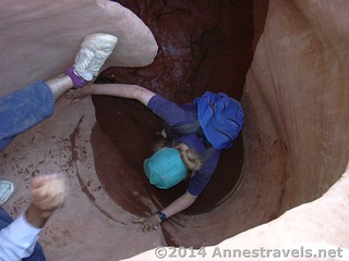
My dad helps me over a mudhole and up a dryfall in Peek-a-Boo Slot
Pros: Wonderful slot canyons
Cons: Hard to get to; bad roads
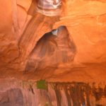
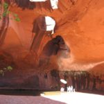
When my family and I were at Grand Staircase Escalante National Park, we visited the slot canyons of Dry Fork Coyote Gulch. The dirt road to the canyon is bad and requires a high clearance vehicle. The trail down into the main wash is steep and slippery.
Once down in the wash, Dry Fork Narrows opens on your left. This canyon is relatively wide for a slot canyon. We found a live tarantula crawling around on the ground.
Scrambling on the rocks in Castle Crags State Park, California (we all loved bouldering…and I guess some things haven’t changed!)
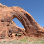
The next canyon downstream is called Peek-A-Boo. To get in, you have to climb up a steep wall that has steps cut into the rock. When we were there, there was a big puddle at the opening and we had to climb on sticks to get across the puddle. Once you get up in the canyon, there are several pretty arches. The canyon is fairly narrow at times, but very pretty. When you get to the end of Peek-A-Boo, you can turn around and come back down the canyon or take and overland trail marked by cairns to the top of Spooky Canyon.
Spooky Canon is extremely narrow. The only disadvantage of coming down from Peek-A-Boo is that there is a large choke stone that is hard to get around. To get past the stone, you can either crawl through a narrow passage under the stone, or drop through a hole from above. As you continue down the canyon, the canyon gets as narrow as 18 inches wide or less and very little light gets in. Squeezing through the narrows was fun!!
These slot canyons are well worth going to.
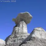
Bisti National Wilderness by “MrConstablemanshipSir”
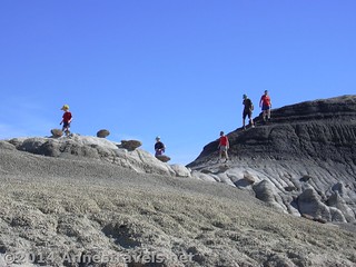
Climbing on the badlands and hoodoos in Bisti
Pros: Beautiful scenery. The kids love climbing in among the rocks
Cons: It would not be hard to get lost, bring a compass
My family and I visited Bisti National Wilderness Area in late October. We got there around nine or nine thirty in the morning, got our packs on, and headed northeast around the flats. After a quarter of a mile, we reached the badlands and rock sculptures [Editor’s Note: it’s probably closer to 0.5 miles to the formations]. It is like nothing else I have ever seen. I have been to Badlands, SD several times and I have also been to Bryce, UT. In places, Bisti was mix of the two with one or the other becoming more apparent now and then. Sometimes it was like neither one. It had some of the neatest rock formations I’ve ever seen, and hoodoos planted on badlands with badlands in the background makes for a real unique beauty. There are no trails except a few cow trails that we found here and there. No trails are a plus as far as I’m concerned. The lack there of adds the sense of adventure as you explore. Take plenty of water and something to eat, because once you are out there you will not want to leave soon.
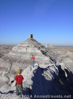
Walking the ridge on the badlands around Angel’s Peak Wilderness Area (near Bisti)
When we headed back to the van around 1:00pm, the flats were getting uncomfortably hot. In the badlands and rock sculptures we had not noticed the heat so much, but out on flats it was really bad. We had a lot of fun playing and exploring and plan on coming back soon.
Best time to go: Spring or fall.
Recommended For: Anyone who does not mind making their own trail, and who likes neat rock sculptures.
And what happened to mine? I don’t know. It must have been lost somewhere along the way. So here’s an early review I wrote for the E-pinions site.
Smith Rock State Park by Anne
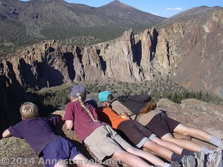
Looking over the cliff edge along the trail to the Monkey Face
Pros: Great views
Cons: Hot sun (and now I’d add – “very difficult to find; roads are hard to follow”)
Smith Rock State Park is a great place to go to hike, to see nice views and colorful rock formations, and to go rock climbing. There are also some horse trails that twist their way through the park. The park, which is in central Oregon, has 623 acres filled with colorful boulders, cliffs, crags, and pinnacles. It was named for a man, John Smith, from Kentucky who came out to Oregon in the 1950’s and then rose to political prominence.
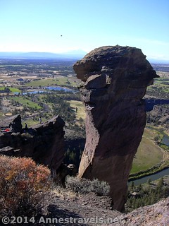
The tight rope walkers on the Monkey Face
We arrived in Smith Rock State Park in the early afternoon. After looking for a place to pay the park fee and finding that none of the machines were working, we looked at a sign in the parking lot near the restrooms that showed all of the trails in the park. We decided to go down to the bottom of the canyon, cross the footbridge over the river, and then go up the monkey face trail. The trail started in the parking lot and then went along the canyon rim to a viewing area. The trail continued from there for a few feet then split. One of the trails was easy and you could ride horses and bikes down it. There was another trail that was reasonably steep, but was shorter, that was only for hikers. The two trails merge at the top, so it really doesn’t matter which trail you take.
We went up the difficult trail, stopping half way up the switchbacks to have a snack and to enjoy the view. Once we got to the top we followed the trail to a place overlooking the monkey. Once you see it, you can’t miss it. Some people had climbed up a rock near the monkey’s mouth and were tight rope walking across a rope that stretched from the rock to the monkey’s mouth. The man even did tricks! Then we went down the easy trail. At the top, the easy trail was much like the difficult trail – steep. Once you got down to the river, though, it became quite level. Looking back, we got good views of the Monkey Face. The trail followed the river back to the foot bridge were you could go back up to the parking lot. Next to the parking lot there is a picnic area. There are also camping facilities.
Recommended: Yes
Recommended for: Anyone; especially families
So there’s some family history for you…and I hope you enjoyed it as much as I enjoyed rereading our reviews!
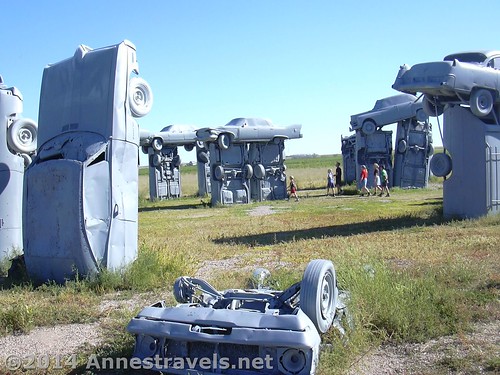
Walking around Carhenge…at this point, we were losing our “stair step” heights and my mom was now shorter than some of the children!
This Week’s Featured Product!
When you’re in the wilderness, you never know how things may go south – and quickly. The trail is longer than you dreamed possible, someone gets injured, a storm washes out the trail…and so on and on. So I always try to carry a package of these with me so that, should something go wrong, at least I’ll be able to purify the water from a stream or spring.