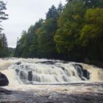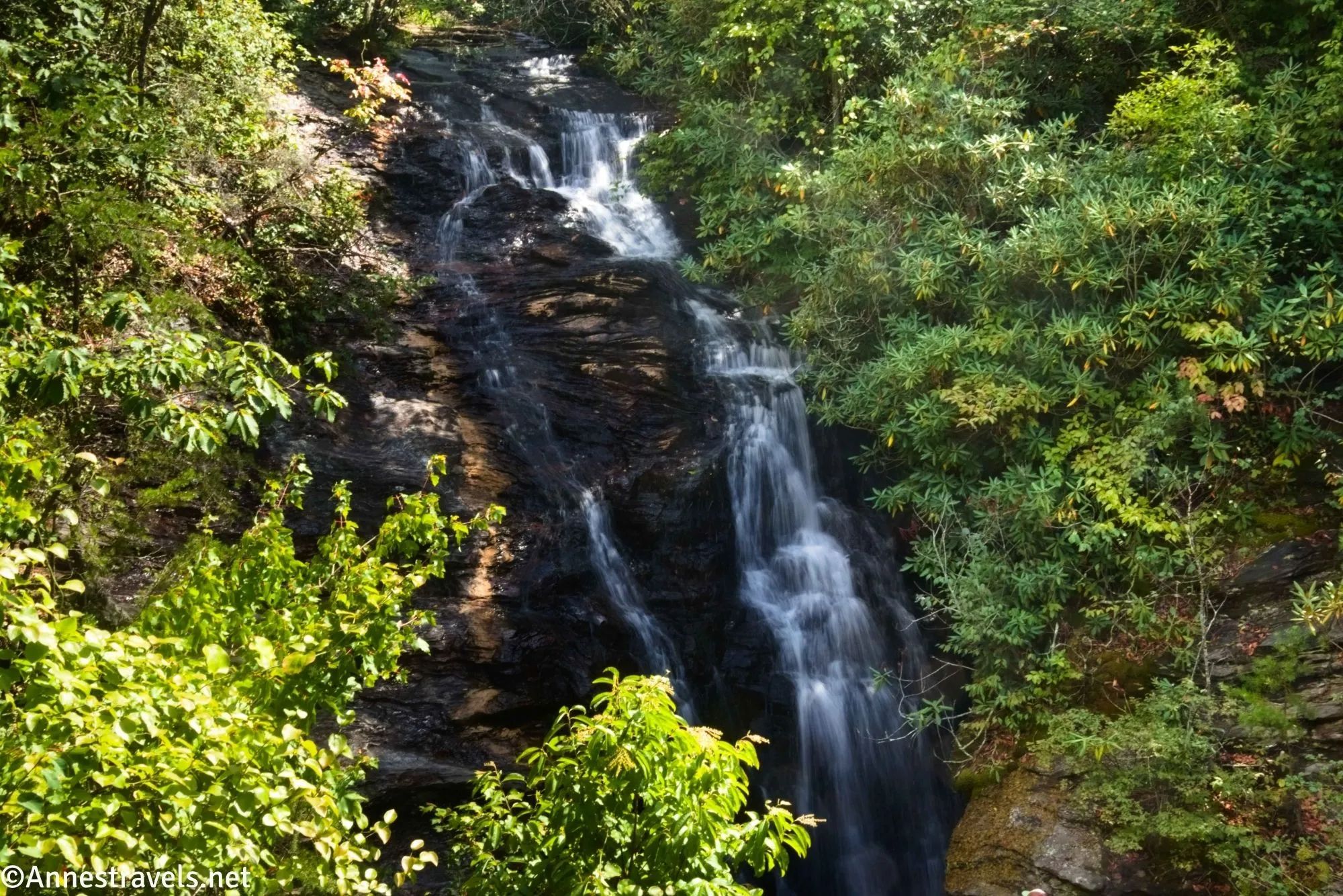
The Upper Cascades in Hanging Rock State Park, NC, are a quick and somewhat easy hike to one of the park’s waterfalls. It’s a pretty falls, though to really enjoy it, you’ll need to scramble down the slippery rocks to the base of the cascade. The trail begins from the same parking area as Hanging Rock, as well as the visitor center, so the Upper Cascade is a great way to end (or begin) a day in the park.
Quick Stats
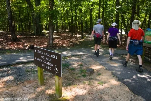
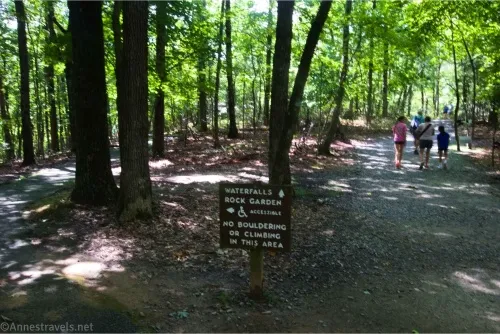
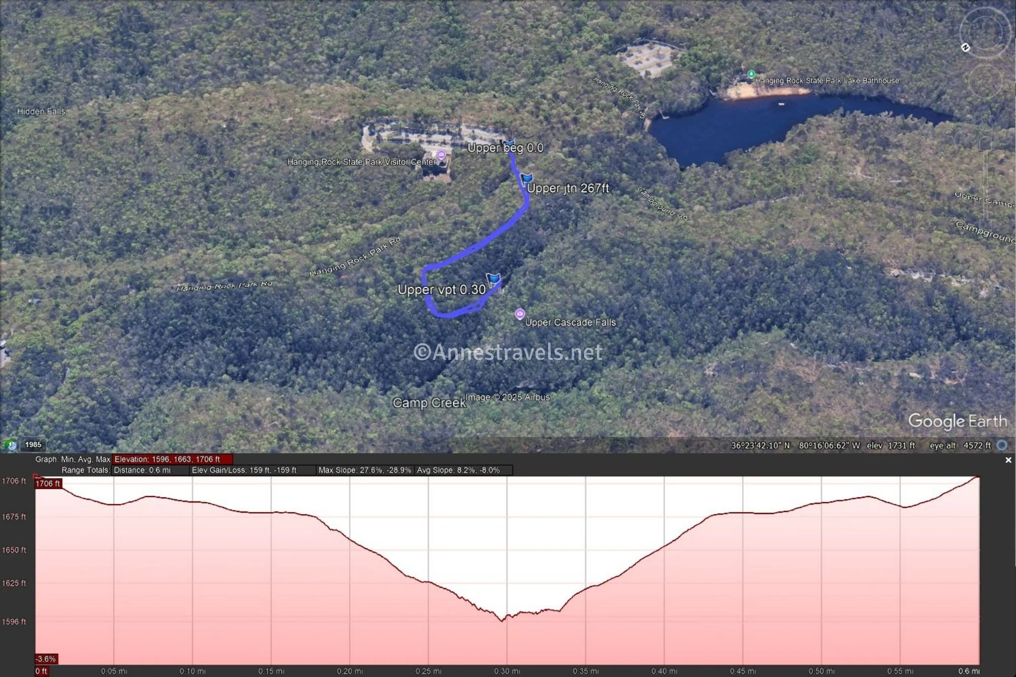
The trail to the Upper Cascades begins at the road end of the parking area for the visitor center. A sign marks the path to the Upper Cascades and the Rock Garden. It then drops to cross the main road through the park – use care, as the road can be busy. After crossing the road, the path enters the woods to head toward the Rock Garden (the path splits off on the left 270ft. from the trailhead). People seemed to be enjoying the rock garden (boulders), but we were in a hurry, so we turned right and headed for the Upper Cascade.
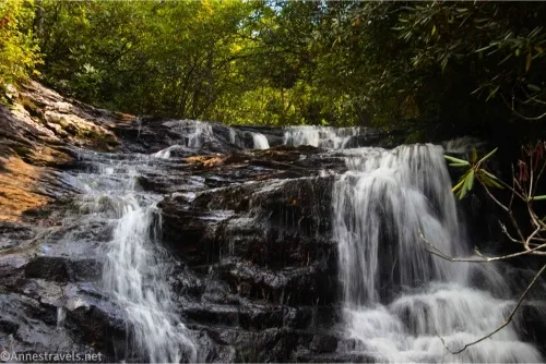
The path is broad and an easy downhill for a while, then it turns and descends steeply. You’ll want to take your time coming back up this on a hot day! Finally, 0.3 miles from the trailhead, the trail enters the viewing area, which is made of wood.
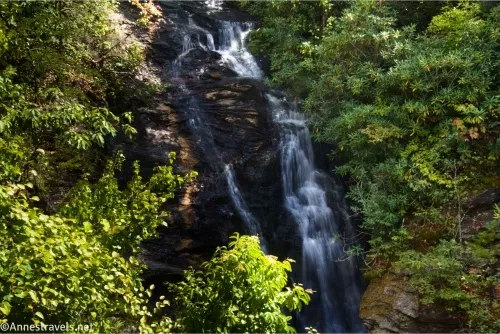
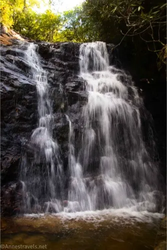
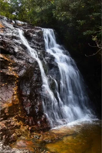
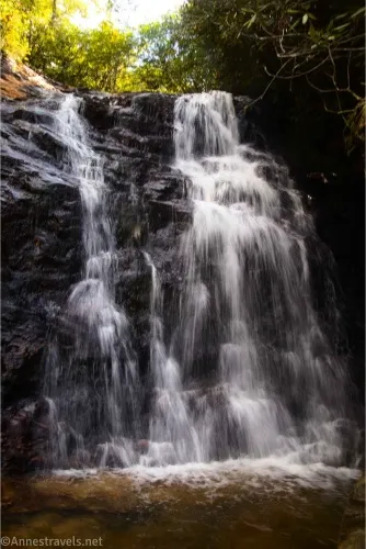
The views from here are good, and you get to see the upper part of the falls, which is invisible from below. However, I wasn’t satisfied. So I followed the stairway that drops you onto slippery rocks and a route (it can’t be classified as a trail) that will bring you down to the edge of the creek.
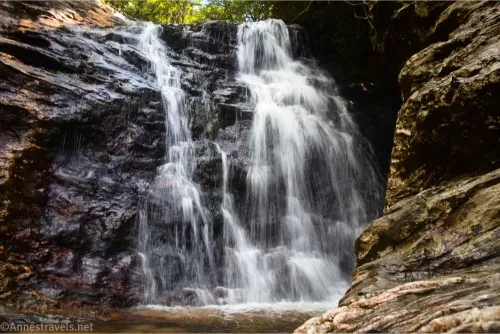
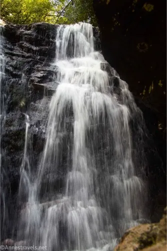
The Upper Cascade Falls is truly beautiful from down here, even though you can only see about half the falls (the lowest drop). Use care, as the rocks are wet and slippery; during times of high flow, the entire area may be underwater or just too dangerous to visit. Use the sense you’ve been endowed with, and don’t try something crazy!
Several kids were swimming in the creek. I didn’t mind them, as long as they stayed out of my pictures. In general, they were very considerate and stayed downstream of where myself and other photographers were trying to get our perfect shot.
From here, it’s just a 0.3 miles hike back uphill to the parking area!
Round Trip Trail Length: I went 0.66 miles total
Elevation Gain: 159ft. (1,706ft. to 1,596ft.)
Facilities: Restrooms and visitor services near the trailhead
Fees: None
Trail Notes: The trail sounds easy, but the uphill is real and very steep. Use extreme care on the rocks, as they’re slippery, and the water if the creek is flooded. I visited about two short weeks before Hurricane Helene tore through western North Carolina, so while Hanging Rock was on the edge of the worst devastation, if things are a little different than I describe or show, it’s probably just the flooding that changed the landscape. Plenty of people stay up on the viewing platform instead of descending to the creek – they get a great view from up there, so if you’re not feeling like an adventure, don’t feel like you’ve missed too much excitement.
Trail 
![]()
Road ![]()
Signs ![]()
Scenery ![]()
![]()
![]()
Would I go 100 miles out of my way for this? ![]()
![]()
![]()
Overall Rating: ![]()
![]()
GPS Coordinates for the Upper Cascade
TH: 36.3941460°, -080.2670440° (36°23.64876′, -080°16.02264′ / 36°23’38.9256″, -080°16’01.3584″) (1,706ft.) (0.0)
Rock Garden Junction: 36.3943200°, -080.2678330° (36°23.65920′, -080°16.06998′ / 36°23’39.5520″, -080°16’04.1988″) (1,685ft.) (267ft.)
Viewpoint: 36.3955680°, -080.2690570° ( 36°23.73408′, -080°16.14342′ / 36°23’44.0448″, -080°16’08.6052″) (1,614ft.) (0.30)
End: 36.3941500°, -080.2670570° (36°23.64900′, -080°16.02342′ / 36°23’38.9400″, -080°16’01.4052″) (1,706ft.) (0.66)
The gpx file for Upper Cascade Falls can be downloaded – please note that this and the GPS Coordinates are for reference only and should not be used as a sole resource when hiking this trail.
Download GPX File size: 7.9 KB Downloaded 196 times
(Note: I do my best to ensure that all downloads, the webpage, etc. are virus-free and accurate; however, I cannot be held responsible for any damage that might result, including but not limited to loss of data, damages to hardware, harm to users, from use of files, information, etc. from this website. Thanks!)
Getting to Upper Cascade Falls
From Winston-Salem, drive north on US-52N for 13 or so miles. Take Exit 122 for Moor-RJR Drive; at the bottom of the ramp, turn left. Drive 2.5 miles, then continue straight for another 1.9 miles after the road changes names to Mountain View Road. Turn left onto NC-66N/North Carolina Hwy 66S and drive 6.9 miles; turn right onto Moores Spring Road. After another 5.4 miles, turn right onto Hanging Rock Park Road. Drive 1.8 miles, turn left toward the Visitor Center, and park in the very large parking area.
From I-77, merge onto I-74E; when I-74 ends, continue straight onto US-52S for 3.8 miles. Use the left lane to take Exit 135 toward W Main Street and Old US 52S. Drive 2.4 miles, then turn left onto NC-268E for 8.4 miles. A light right will keep you on NC-268E for another 3.1 miles. Turn right onto Dan George Road for 2.1 miles; turn left onto Moores Spring Road and drive another 2.6 miles to turn right onto Hanging Rock Road. Drive 1.8 miles, turn left toward the Visitor Center, and park in the very large parking area.
From the Martinsville area, drive US-58W about 13.6 miles after crossing US-220. Turn left onto Nettle Ridge Loop for only 0.2 miles; turn left onto Moorefield Store Road. After 4.8 miles (during which you’ll enter North Carolina), turn left onto VA Line Road for 1 mile, then turn right onto NC-704 W for 0.1 mile, then turn left on Moore Road for 3.3 miles. Heave a sigh of relief when you turn onto NC-8S because you get to stay on it for 6.2 miles. Turn left to stay on NC-8S. After 0.7 miles, turn right onto Piedmont Springs Road for 0.9 miles, then onto Hanging Rock Park Road for 2.3 miles. Turn left toward the Visitor Center and park in the very large parking area.
More Waterfalls in North Carolina
Featuring 150 waterfalls across the state, this is a waterfall-lover’s dream book! Buy your copy here, currently on sale for $19.40.