
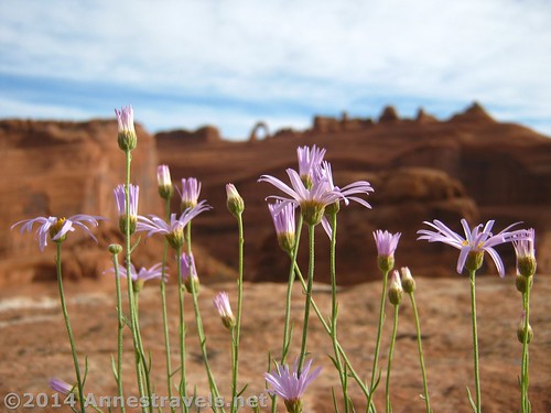
Wildflowers at the Upper Delicate Arch Viewpoint
One day, I was reading a touristy book. These usually aren’t down my line of things to do on a trip, but occasionally a good trail is mentioned. In this particular book, there was a photo of Delicate Arch from a very unique angle. Of course, the book didn’t say where the picture was taken, but Google’s a good place to look up almost anything. Turns out, the picture was taken near the Upper Delicate Arch Viewpoint – nowhere near the trail we’d taken at least 3 times before to stand under Delicate Arch proper. This was across the canyon, with some spectacular, if slightly distant, views of the arch. So, next time we were in the area, we took an early morning opportunity before heading home to walk the supposedly 1 mile (1.6 km) (RT) trail. It was spectacular, though I suspect it would have been even nicer if the sun had been shining slightly more clearly.
Quick Stats
The view
We drove into the Delicate Arch Viewpoint parking area very early on Memorial Day Saturday morning. We were the only ones there, which was nice: considering the line of traffic coming into the park as we were leaving a couple hours later, I suspect this solitude was very short-lived! We all walked to the Lower Delicate Arch Viewpoint (0.1 mile (0.1 km) RT), enjoyed the early morning sun on Delicate Arch, and then went back to the van for breakfast. Then we all headed up the 0.5 mile (0.8 km) one-way trail to the Upper Delicate Arch Viewpoint.
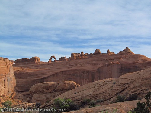
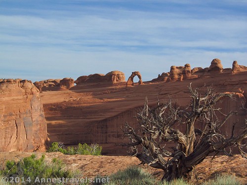
Early morning sunshine on the “other side” of the arch than most people see
The trail was generally well-maintained as it climbed fairly steeply uphill. It is somewhat rocky, with rock steps in places, so watch your step. After hiking 0.5 miles (0.8 km), we came to a small viewing area and a sign: this was the end of the trail and the Upper Delicate Arch Viewing Area. It was a very nice viewing area, but there was one big problem. You couldn’t see anything. At least, you couldn’t see anything worth seeing. So, we followed the very well-defined social trail that continues right past the sign and onto the slickrock. (Note: on Google Maps, the trail continues to the left; I don’t know if this is just old information or if the sign is wrong, but it might be worth checking out.)
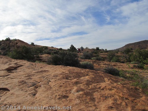
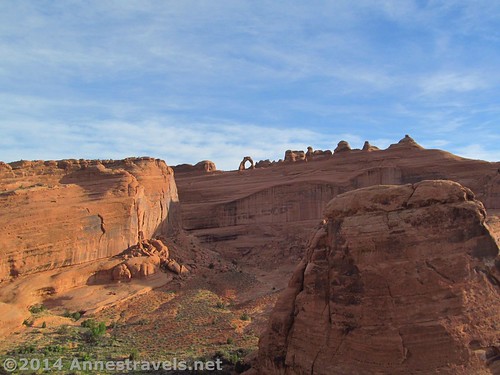
Walking across the slickrock
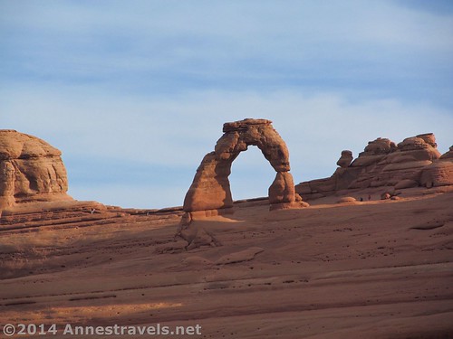
The social trail peters out fairly quickly, and others begin and end just as fast. I’d recommend simply heading in the right direction until you come close enough to the cliff edge that you can see Delicate Arch, about 0.5 miles (0.8 km) away across a huge canyon from where you’re standing. The views from here are very nice, and I’d say it’s well worth the hike (which is now about 1.5 miles (2.4 km) RT). We wandered around on the slickrock for a bit, finding different vantage points to see the arch from. If you walk far enough right up the rocks, you can get a view of Moab.
View along the slickrock
We returned to the van without seeing another soul, except for early risers standing under Delicate Arch. Then we went over to Double Arch and the tour buses began unloading…time to head out of the park…and head for home!
Round Trip Trail Length: About 1.5 miles (2.4 km)
Beginning Elevation: 4,293 ft. (1,308 m)
Highest Elevation: 4,686 ft. (1,428 m)
Net Elevation Change: 393 ft. (119 m)
Facilities: Primitive restrooms in the parking area
Fees: $10 per vehicle to enter Arches National Park, valid 7 days. America the Beautiful (Interagency), Senior (Golden Age), Access (Golden Access), Volunteer, Military, and Big Bend Annual Passes also accepted
Trail 
Road
Signs
Scenery
Would I go 100 miles out of my way for this?
Overall Rating:
Key GPS Coordinates for Upper Delicate Arch Viewpoint
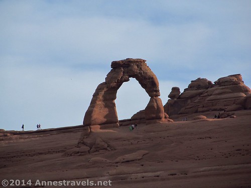
Early risers at Delicate Arch
Upper Delicate Arch Viewpoint Trail Beginning: 38.73407N / -109.50098W (38° 44′ 2.652″ / -109° 30′ 3.5274″)
Lower Delicate Arch Viewpoint: 38.73423N / -109.50016W (38° 44′ 3.2274″ / -109° 30′ 0.5754″)
Beginning of upper viewpoint trail: 38.73418N / -109.50102W (38° 44′ 3.048″ / 109° 30′ 3.6714″)
End of upper viewpoint trail: 38.73757N / -109.50088W (38° 44′ 15.2514″ / -109° 30′ 3.1674″)
View 1: 38.73815N / -109.49784W (38° 44′ 17.3394″ / -109° 29′ 52.2234″)
View 2: 38.73777N / -109.49493W (38° 44′ 15.9714″ / -109° 29′ 41.7474″)
The gpx file for the Upper Delicate Arch Viewpoint can be downloaded – please note that this and the GPS Coordinates are for reference only and should not be used as a sole resource when hiking this trail.
Download GPX File size: 34.6 KB Downloaded 84 times
(Note: I do my best to ensure that all downloads, the webpage, etc. are virus-free and accurate; however, I cannot be held responsible for any damage that might result, including but not limited to loss of data, damages to hardware, harm to users, from use of files, information, etc. from this website. Thanks!)
Getting to the Upper Delicate Arch Viewpoint:
A more “realistic” view from the upper viewpoint (i.e., little or no zoom on the camera)
From Moab, UT, drive about 4.5 miles (7.2 km) north on US-191 N to the entrance to Arches National Park. Turn right onto the entrance road. (This is well-marked.) Drive 12.3 miles (19.8 km) through the entrance kiosk and past the visitor center up the scenic drive. After the 12.3 miles (19.8 km), turn right onto Delicate Arch Road; the Delicate Arch Viewpoint Parking Area is at the end of the road, 2.3 miles (3.7 km) away.
Alternatively, from I-70, take Exit 182 to US-191 S and drive 26.9 miles (43.3 km) to the entrance road to Arches National Park, on the left (it’s well-marked). Watch for arches on the left as you drive US-191; you can see quite a few in the distance from the highway. Enter the park and drive 12.3 miles (19.8 km) passing through the entrance kiosk, past the visitor center, and up the scenic drive to the Delicate Arch Road, on right. Turn here and drive 2.3 miles (3.7 km) to the Delicate Arch Viewpoint Parking Area.
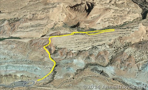
Visual map of my exploration of the Upper Delicate Arch Viewpoint
Zoom map out to browse nearby hikes & places of interest
This Week’s Featured Product!
Arches National Park offers many shorter dayhiking opportunities, and nearby Canyonlands National Park also has several fabulously beautiful dayhikes. This book aims to cover these easier trails, from after-dinner strolls to family-friendly hikes.
Pingback: Alternate Views of Famous American Wilderness Areas
Pingback: 15 of the Best Day Hikes in Southern Utah - Anne's Travels
Pingback: Epic Day Hiking Road Trip to Southern Utah - Anne's Travels