When I visited the Sawtooth Mountains last fall, I decided that we should save our last day to climb the highest point in the range – Thompson Peak. I printed trip reports off of the internet and it sounded fairly simple. A trail partway, a scramble partway, 12 miles RT. Difficult but doable. Except… well, the reality was far more spectacular than they said, but it was also much longer and more difficult! So while I highly recommend the hike for the views, I’d also suggest that you do it with more daylight and a little bit faster hiking than we did. Because while we hiked about 7 miles from the trailhead, we were still at least 0.3 miles up a scree scramble from the peak!
Quick Stats

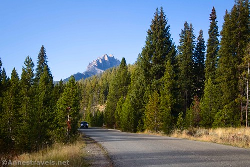
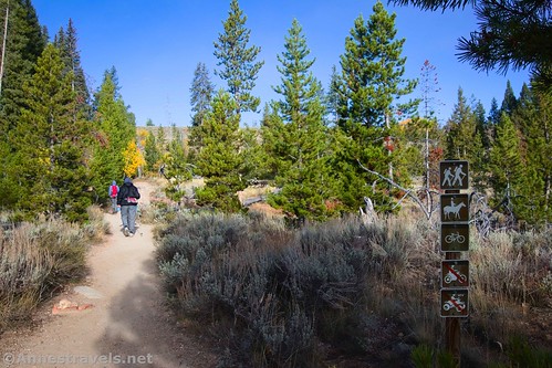
The path begins at the hiker’s parking area near the Redfish Lake Lodge. Because this is such a touristy, resort-y area, it can be difficult to find the trailhead. But once you’re in the parking lot, a sign points toward the “Trail.” Walk through the pines for a short distance to cross over a blacktop road. The real trailhead is just on the other side of this road, complete with all of the signs and maps and kiosks you’d expect at a trailhead in the Sawtooth Mountains.
From the trailhead signs, follow the Fishhook Creek Trail for 0.4 miles to a trail junction, signed for (among other things) Bench Lakes to the left. You want to go right (straight), following the sign for the Fishhook Creek Trail and Marshall Lake.

Another 0.4 miles later, a small sign points right toward Marshall Lake – you want to turn right here, leaving the fairly easy, benign Fishhook Creek Trail behind. (I hear that Fishhook Creek is also a great hike, but I had higher destinations in mind for the day.)
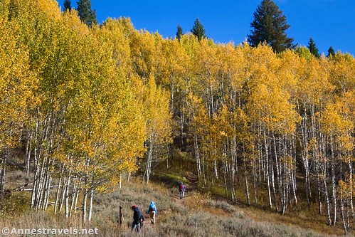
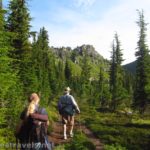
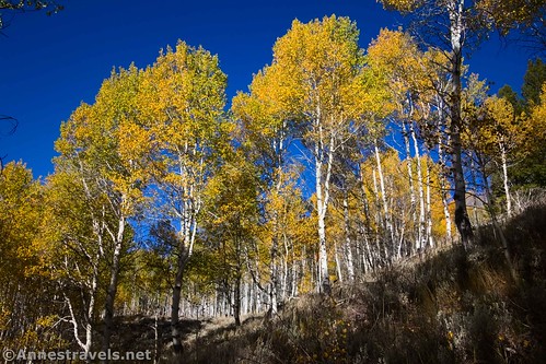
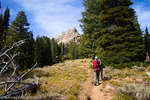
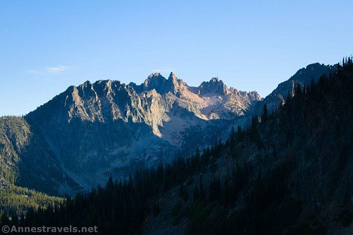
The trail fairly quickly begins to ascend through an aspen forest. Just before this are some truly spectacular views toward Thompson Peak.

Even better, the aspens were turning gold. I’ve never seen a forest quite like this one – spectacular!
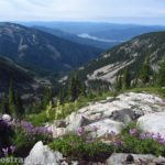
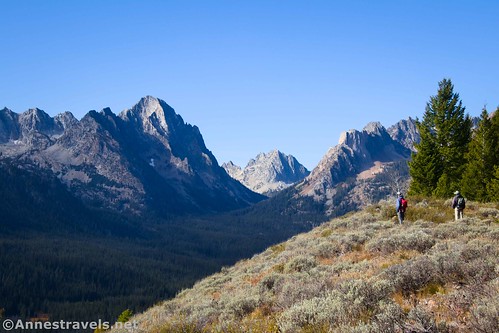
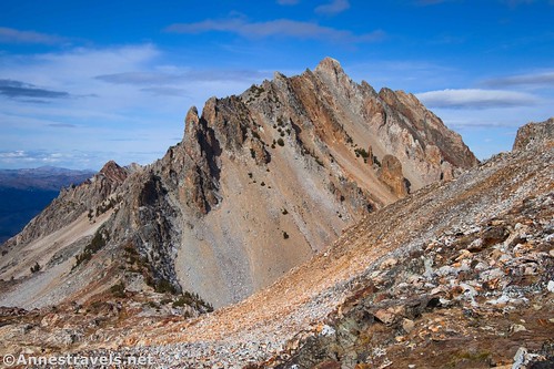
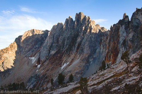
The trail rises up to the ridgeline and the Alpine Way junction just before mile 1.6. Follow the sign here toward Marshall Lake – you’ll be hiking uphill on the ridgeline and fairly quickly pop out of the trees (at least briefly). By scrambling the short distance up to the ridgeline, you get fabulous views to Horstmann Peak and Braxton Peak, as well as the valley between Horstmann Peak and Thompson Peak (which is out of sight behind some trees). I believe the War Bonnet is visible up the valley between the two peaks.
The trail continues up the ridgeline to enter the Sawtooth Wilderness about mile 2.6. Fill out the free (but required) permit form before walking through the thickening trees.

At 4.1 miles from the trailhead, an unmarked junction strikes off on the left. It’s well-traveled and continues uphill while the path to Marshall Lakes continues right (straight) through the trees. This is the Thompson Peak Trail, and official maintenance ends here.
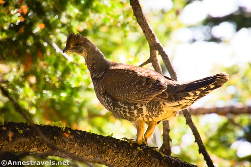
The trail is well-defined as it heads upward through the trees, more steeply than before. I saw a ruffed grouse up in a tree.
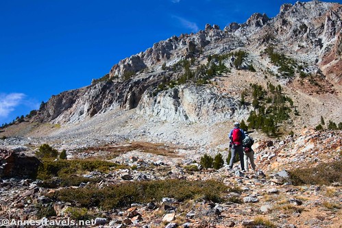
The trail heads upward, then it begins working its way along the slopes of William Peak’s southern ridgeline. Someone I met on my way up to Goat Lake a few days earlier had described this section of trail as “cliffy,” and he was totally right! It’s not the type of trail you’d want to do if you can’t stand heights. But at least there are a few views to Thomspon Peak and out to the valley.
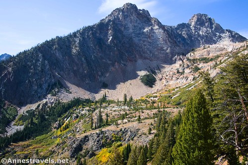
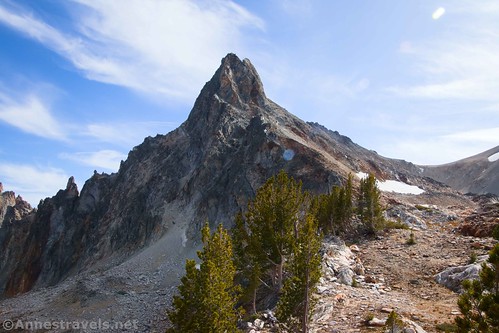
The worst part of this section of the trail (in my opinion) was where the trail splits into multiple social routes in a scree slope. I found that by staying fairly high, I missed out on the sketchy lower scramble once the path meets up with a wall of brush on the far side of the scree field. But it’s really up to you, and expect some sketchy Class 2+ scrambling in this section. Thankfully, the trail improves after this to take you up to lovely meadows between Williams Peak (right) and Thompson Peak (left – it looks impossible to ascend without professional climbing gear from this angle) about 0.6 miles after leaving the trail to Marshall Lake (it feels like much more).
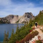
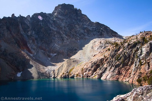
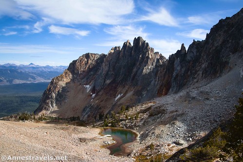
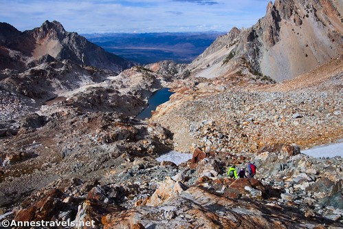
The trail becomes vaguer beyond the meadows but is still defined enough as it rises through rocks to an overlook of an unnamed lake in the cirque below Thompson Peak. (I’ll call it Thompson Lake.) This is a good turn-around spot as a day hike. The views of the lake are spectacular, and you get great views back out to the valley, too.
We ate lunch in the sunshine on a rocky slab above the lake (did you know that tomato-basil chicken packets from Walmart really aren’t kind to the taste buds?) Then we tried to pick up the trail to ascend higher in the cirque between Thompson Peak and Williams Peak.
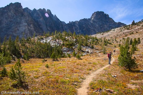
But the trail beyond this is vague at best. We picked it up from time to time and lost it regularly. Racing daylight, we mostly just did our best and were careful – it’s all rocks up here.
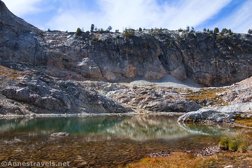
About 0.6 miles above where we ate lunch, we came to the other small lake in the cirque. The easy hiking ends here, so just be forewarned (as if this last section was easy!). I hear that most people who do this as an overnight hike camp in this general area.
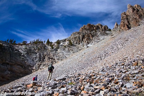
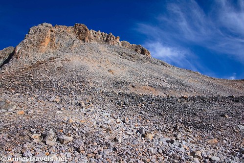
From the small lake, maps tell you to go along the left side of the lake and up the headwall. I didn’t have those directions, so we turned right-ish to ascend the scree field. It’s loose and slippery, so use extreme care. I’m used to the larger rocks staying put, but the larger stones here tended to slide down the mountain – with you on top! Do your best to rise up toward the headwall of the cirque.
The headwall posed a massive barrier. It’s almost sheer and about 10-20ft. tall – not exactly a fun scramble for those of us who have already hiked 5+ miles and don’t have technical climbing gear with us! Most of my group shied right, closer to Williams Peak, and found a way up. I headed a little lower and found a nice crack that gave access up the wall via a Class 3+ route (one move felt close to a Class 4). I hear my group’s route was easier scrambling, but I preferred mine because it meant I didn’t have to rise so high on the scree field and was shorter overall.
Once on top of the saddle (breathe a sigh of relief!), we headed left. Again, we found traces of a trail and followed it as best as we could. There was quite a bit of snow up here (it was late September), so we did our best to skirt that while still staying safe on the scree. It’s wild country up here!
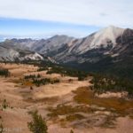
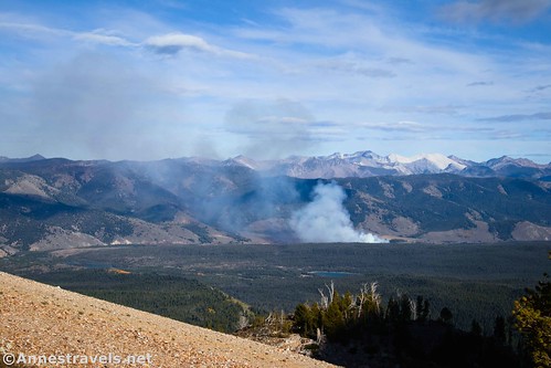
About 7 miles from the trailhead, we called a halt. From here, we could clearly see the route up to the top of Mt. Thompson – another half mile or more of very steep scree scramble from our estimations, and given thin air and elevation gain, it would have taken us at least 45 minutes to get up there. The daylight was seriously moving on, and we were already worried about getting back down before dark. It just didn’t seem wise to push for the peak.
But the views! Wow! If I thought the views before this were great (and they were!), this was an entirely new level. We were above another cirque, with blue lakes (unnamed to my knowledge – I think the biggest one is called 8865) below us in red/brown/brown rocky bowls. (Goat Lake is out of sight down this valley.) Sawtooth peaks were above. Incredible!

We ate a quick snack and then descended. We did make it back to the main trails before dark, but it was moonrise well before we were back to the parking lot!

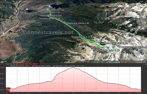
Round Trip Trail Length: My GPS was reading 14 miles when we arrived back at the parking area. According to maps, it was another 0.3 miles from where we stopped to the summit, but it would feel a lot more due to the steepness and the scree.
Elevation Gain: 3,827ft. (6,563ft. to 10,091ft.) how I went – Thompson is 650ft. higher than where I turned around
Facilities: None (there aren’t even bathrooms at the trailhead!)
Fees: None
Trail Notes: I’d try this route again on a day with more daylight (but not with thunderstorms!) There are several ways to make this hike easier/shorter with less scrambling – good turnaround points are the ridgeline above the Alpine Way junction (about 4 miles RT) and the views over Thompson Lake (10.8 miles RT). Be ready for significant scrambling, wayfinding, and general adventure on this hike.
Trail 
![]()
![]()
![]()
Road ![]()
Signs ![]()
Scenery
Would I go 100 miles out of my way for this?
Overall Rating: ![]()

GPS Coordinates for Climbing Thompson Peak
TH: 44.1472920°, -114.9196210° (44°08.83752′, -114°55.17726′ / 44°08’50.2512″, -114°55’10.6356″) (6,563ft.) (0.0)
Bench Junction: 44.1477740°, -114.9251820° (44°08.86644′, -114°55.51092′ / 44°08’51.9864″, -114°55’30.6552″) (6,680ft.) (0.43)
Marshall Junction: 44.1497220°, -114.9316090° (44°08.98332′, -114°55.89654′ / 44°08’58.9992″, -114°55’53.7924″) (6,718ft.) (0.82)
Alpine Way Junction: 44.1529560°, -114.9371710° (44°09.17736′, -114°56.23026′ / 44°09’10.6416″, -114°56’13.8156″) (7,123ft.) (1.58)
Enter Sawtooth Wilderness: 44.1489080°, -114.9563470° (44°08.93448′, -114°57.38082′ / 44°08’56.0688″, -114°57’22.8492″) (7,500ft.) (2.65)
Thompson Peak Junction: 44.1495680°, -114.9840670° (44°08.97408′, -114°59.04402′ / 44°08’58.4448″, -114°59’02.6412″) (8,027ft.) (4.17)
Lake view: 44.1460820°, -115.0001320° (44°08.76492′, -115°00.00792′ / 44°08’45.8952″, -115°00’00.4752″) (9,043ft.) (5.39)
Small lake: 44.1461830°, -115.0089910° (44°08.77098′, -115°00.53946′ / 44°08’46.2588″, -115°00’32.3676″) (9,510ft.) (6.10)
Turn around: 44.1418889°, -115.0137222° (44°08.51333′, -115°00.82333′ / 44°08’30.8000″, -115°00’49.4000″) (10,019ft.) (7.01)
End: 44.1475420°, -114.9196480° (44°08.85252′, -114°55.17888′ / 44°08’51.1512″, -114°55’10.7328″) (6,563ft.) (14.16)
The gpx file for my hike (almost) up Thompson Peak can be downloaded – please note that this and the GPS Coordinates are for reference only and should not be used as a sole resource when hiking this trail.
Download GPX File size: 235.9 KB Downloaded 346 times
(Note: I do my best to ensure that all downloads, the webpage, etc. are virus-free and accurate; however, I cannot be held responsible for any damage that might result, including but not limited to loss of data, damages to hardware, harm to users, from use of files, information, etc. from this website. Thanks!)
Getting to the Thompson Peak Trailhead (Fishhook Creek Trailhead)
From Stanley, Idaho, make your way to ID-75; drive south toward Ketchum. After 4.3 miles, turn right onto Redfish Lake Road. At the traffic circle, 1.2 miles from the last turn, take the first exit to stay on Redfish Lake Road. About 0.6 miles later, turn right into the parking area.
From Ketchum, Idaho, drive north on ID-75. After about 56 miles, turn left on Redfish Lake Road. At the traffic circle, 1.2 miles from the last turn, take the first exit to stay on Redfish Lake Road. About 0.6 miles later, turn right into the parking area.
The approach to the trailhead is a little confusing, with multiple campgrounds and roads to resorts. I highly recommend a GPS to make sure you’re staying on the right road.
More Hikes in the Sawtooth Mountains!
Take to the trails of the Sawtooth Mountains with this guide – one of the first and best about the region! With over 140 adventures to choose from, you’re sure to find gorgeous views, peaceful lakes, and much more. Buy your copy here!