
If you’re looking for one spectacular hike – that doesn’t go to a lake – near Idaho’s Sawtooth Mountains, the hike to Blackmon Peak fits the bill! It’s not an easy hike (we’re talking over 2,000ft. elevation gain here), but the views from the ridgeline and peak down on Antz Basin and the surrounding White Cloud Mountains make it a true gem. And that’s not even mentioning the great views of the Sawtooths across the valley!
Quick Stats
Something I should probably admit here is that I somehow lost my GPS track from this hike. I have no idea if I just forgot to save it (unlikely but perfectly possible) or if my GPS ate it sometime between my saving it and transferring it to my computer. But I do have my GPS coordinate file (automatically saved by the GPS). So the coordinates should be right even if the map (which I tried to recreate – thanks GPS Visualizer!) and GPX download are… close.
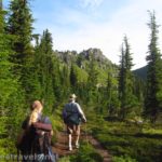
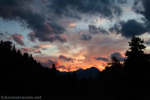
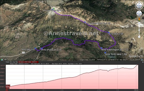
It was a cloudy, moody morning when I started out. I’d spent the night at the trailhead, and it was quiet and uneventful except for something huge walking through the parking lot during the night (I’m thinking it was an elk). (Actually, there are quite a number of campsites further down the road which are much nicer.) The trailhead tells you to take the trail for Fourth of July Lake, Washington Lake, and Born Lakes. Almost immediately, the path crosses Fourth of July Creek.

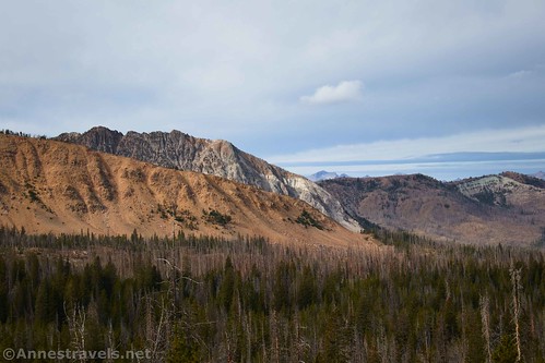
The trail passes through the forest up to a turnoff for Phyllis Lake after 0.15 miles. Cross the road here and continue toward Fourth of July Lake. (The road goes up to a mine area – you can see the mine from the ridge and Blackmon Peak later on.) The scenery after this continues to be mostly in the forest, though you’ll enter a burned area before reaching the turnoff for Fourth of July Lake. Before the burned section, you’ll cross at least one marshy area – fun times! – and cross a small creek, as well.
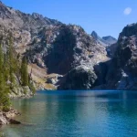
After about 1.7 miles, you’ll come to a trail junction marked for Washington Lake (right) and Born Lakes (left). If you turn right here for about a tenth of a mile, you’ll come to Fourth of July Lake. I did that, but I’ll detail it in another post. To reach Blackmon Peak, turn left toward Born Lakes.

While you’ve been moderately ascending for most if not all of the hike, at this point, the trail really begins to climb. We puffed and panted our way up the next 0.7 miles to an unnamed lake, where we paused to have a snack.

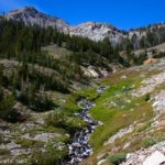
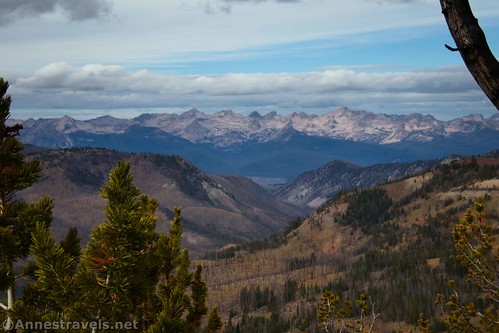
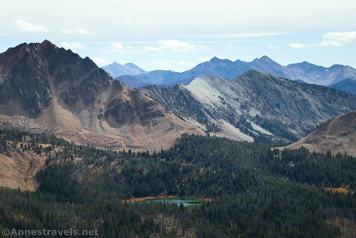
The trail continues steeply upward, angling up along the side of the hill. Views begin to open up in a peek-a-boo sort of way to nearby peaks and valleys and the Sawtooth mountains across the valley.
Shortly before cresting the ridgeline, we saw a trail on the right leading up to a slightly higher view on the ridgeline. Intrigued, and hopeful of views, and not realizing just how close we were to the ridgeline, we took the side trail. The views were amazing!

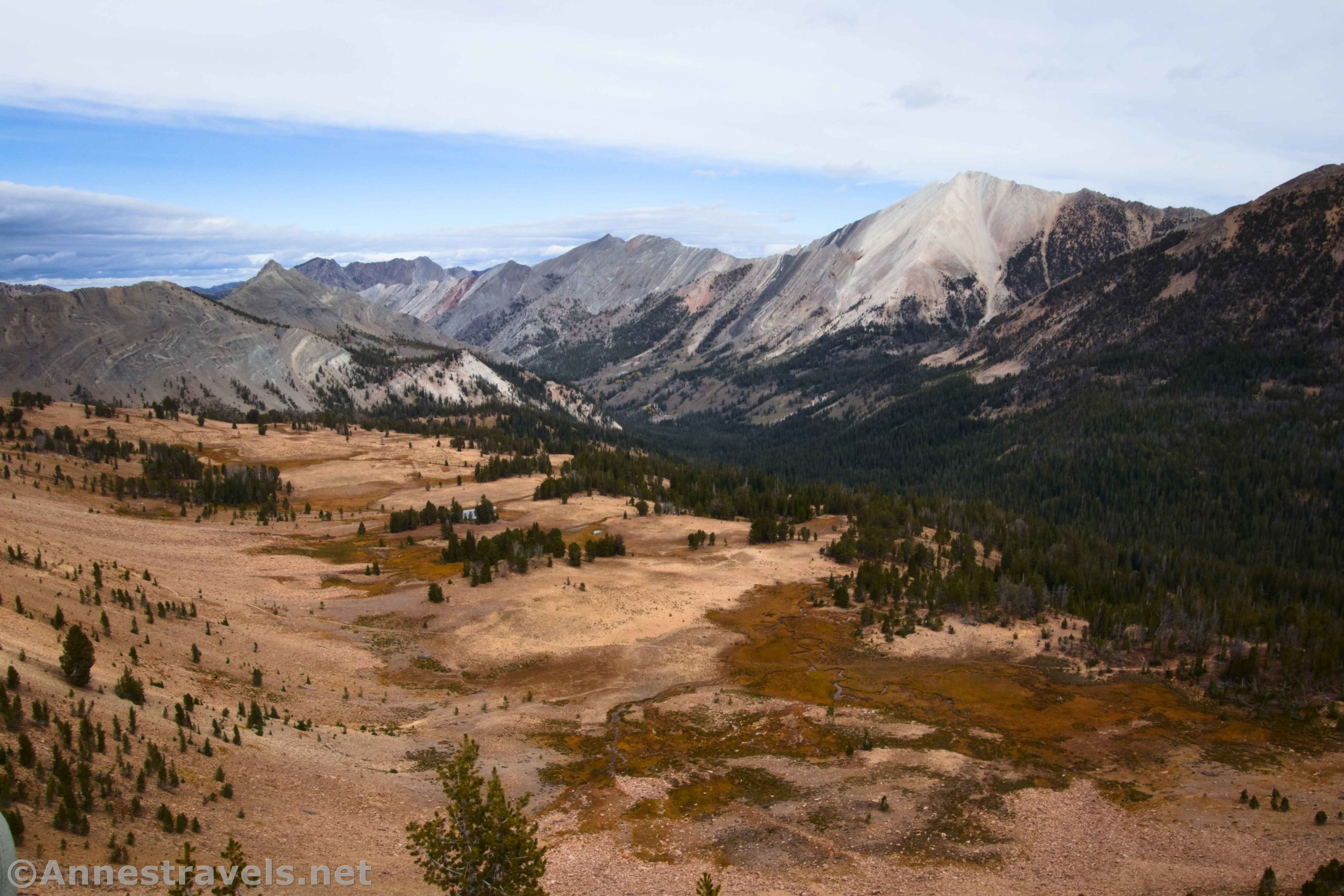
From there, it was an easy scramble down to the wilderness boundary sign. Here the trail for Antz Basin (and Born Lakes) turns right to descend into the basin. But we’re mountain-top views kind of people, so instead of following the trail, we followed a well-worn social path straight along the ridgeline.

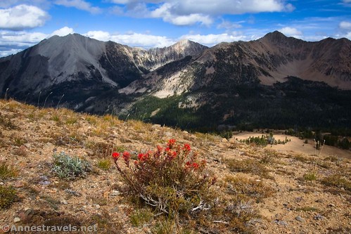
The hiking is fairly easy (compared to what you’ve just come up, at least) with only minor scrambling in a few places (up to a mild Class 3 due to exposure, not difficulty). But in general, it’s a sweet little ridgeline ramble with fantastic views down into Antz Basin (right) and across the valley (left) to the Sawtooth Mountains.

The trail gives out after a while, but it’s not hard to figure out where to go: Stay on the ridge!

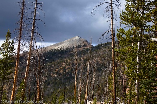
At last, about 3.8 miles from the parking area, you’ll come to the base of Blackmon Peak. It looks very steep, long, and difficult. In reality, it’s steep, short (about 0.1 miles), and a slightly difficult Class 2 scramble. Before I knew it, we were at the top!
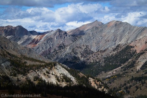
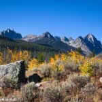
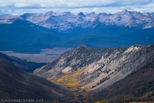
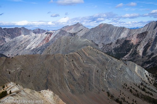
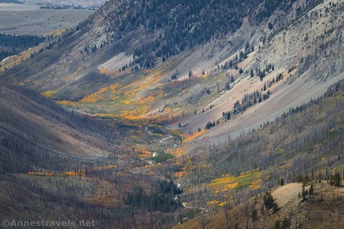
You’ve been seeing fabulous views the entire way along the ridgeline, but this was the icing on the cake. The geological wonders in the White Cloud Mountains (including colorful hills, towering peaks, and prominent geological folds) were absolutely jaw-dropping. And that’s not including the lovely Antz Basin, the Sawtooth Mountains across the valley, and views that range far north and west beyond the mountains.
The autumn colors were also nice.
Retrace your steps to return to the parking area. Blackmon Peak is not an easy hike by any means, but it is well worth the effort to see the view!
Round Trip Trail Length: 7.8 miles out & back (8.2 miles if you tack on 4th of July Lake, too)
Elevation Gain: 2,100ft. (8,749ft. to 10,272ft.)
Facilities: Primitive restrooms at the trailhead
Fees: None

Trail Notes: Born Lakes and Antz Basin are a very popular (by local standards only) backpacking destination. Many even do a loop over to Washington Lake and back to the trailhead. Use care as you scramble the ridgeline – there are a few small but sketchy moves. Be wary of hunters in season as well as afternoon thundershowers in summer – this is a very exposed ridgeline!

Trail 
![]()
![]()
Road ![]()
Signs ![]()
Scenery
Would I go 100 miles out of my way for this?
Overall Rating: ![]()

GPS Coordinates for Blackmon Peak & Antz Basin
TH: 44.0466080°, -114.6576190° (44°02.79648′, -114°39.45714′ / 44°02’47.7888″, -114°39’27.4284″) (8,775ft.) (0.0)
Phyllis Lake Junction: 44.0465470°, -114.6552470° (44°02.79282′, -114°39.31482′ / 44°02’47.5692″, -114°39’18.8892″) (8,803ft.) (0.16)
Washington Lake Junction: 44.0454230°, -114.6342110° (44°02.72538′, -114°38.05266′ / 44°02’43.5228″, -114°38’03.1596″) (9,376ft.) (1.72) (1.6)
4th of July Lake: 44.0440770°, -114.6332530° (44°02.64462′, -114°37.99518′ / 44°02’38.6772″, -114°37’59.7108″) (9,371ft.) (1.84)

Unnamed lake: 44.0499000°, -114.6306770° (44°02.99400′, -114°37.84062′ / 44°02’59.6400″, -114°37’50.4372″) (9,708ft.) (2.58) (2.2)
Wilderness Boundary: 44.0535550°, -114.6391230° (44°03.21330′, -114°38.34738′ / 44°03’12.7980″, -114°38’20.8428″) (9,899ft.) (3.22)
Blackmon Peak: 44.0582160°, -114.6525640° (44°03.49296′, -114°39.15384′ / 44°03’29.5776″, -114°39’09.2304″) (10,291ft.) (4.15) (3.5)

The gpx file for Blackmon Peak can be downloaded – please note that this and the GPS Coordinates are for reference only and should not be used as a sole resource when hiking this trail. Also note that I created this on a map, so it may not be quite as accurate as some of my other gpx downloads!
Download GPX File size: 35.4 KB Downloaded 453 times
(Note: I do my best to ensure that all downloads, the webpage, etc. are virus-free and accurate; however, I cannot be held responsible for any damage that might result, including but not limited to loss of data, damages to hardware, harm to users, from use of files, information, etc. from this website. Thanks!)

Getting to the Blackmon Peak Trailhead
From Stanley, Idaho, drive south on ID-75S (toward Ketchum). After 14.8 miles, turn left onto Forest Road 70209 (marked for the Fourth of July Lakes). This is after crossing Fourth of July Creek; the road just north of Fourth of July Creek is not the right one. Continue up the dirt road for 10 miles to the obvious trailhead at what might as well be the end of the road.
From Ketchum, drive north on ID-75N. After 46.1 miles, turn right onto Forest Road 70209. This is just before crossing Fourth of July Lake; if you cross the bridge, you know you’ve gone too far. Continue up the dirt road for 10 miles to the obvious trailhead at what might as well be the end of the road.
I found the road to be slow and bumpy but quite passable. High clearance was an asset but I recall seeing both pickups and low-clearance cars at the trailhead. There are quite a few campsites for dispersed camping along the road.
Today’s Featured Product!
Explore the Sawtooth and White Cloud Wildernesses with this classic guide to the area. It includes 143 trails, including GPS coordinates. Buy your copy here!