
Some time ago, I saw a photo of Sawtooth Lake in the Sawtooth Mountains of Idaho. My first thought was something like, “I want to go there! That looks amazing!” It didn’t work out (we went to Glacier National Park instead), but when I was in Idaho last fall, Sawtooth Lake was high on my list of trails to hike. It didn’t disappoint. Besides the lake, I found great views of a sawtooth ridgeline, another pretty lake, and spectacular views beyond where most people turn around. It turned out to be one of my favorite hikes on the entire trip in terms of alpine beauty!
Quick Stats
Sawtooth Lake is also one of the most popular hikes in the Sawtooth Mountains. So be ready to share the parking area (which was only partially ample enough for fall hikers… I can’t imagine it on a summer weekend). Because of the popularity, campfires are not allowed near the lakes and dogs must be leashed from July 1 through Labor Day.
The trail to Sawtooth Lakes begins at the Iron Creek Trailhead (note that the very primitive toilet at the trailhead closes before October 1… we were surprised to come back one day and find the doors locked. Not that it had toilet paper for several days before that, but still…). Fill out the free permit form, attach it visibly to your backpack, and head up the dirt trail.

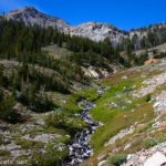
The path is wide and a gentle uphill for 1.15 miles to where you enter the Sawtooth Wilderness. Iron Creek is on your left for much of this trek. Continue up the trail to a junction with the path to Marshall Lake on the left at mile 1.3. Continue right toward Sawtooth Lake. The final junction in this section is 0.6 miles later in a small clearing. Turn left toward Sawtooth Lake instead of right toward Stanley Lake.

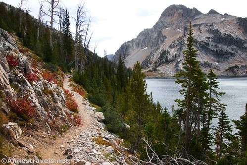
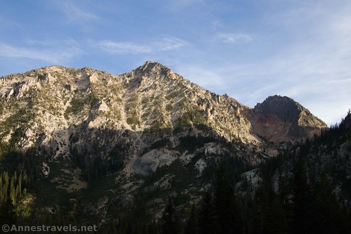
After the Stanley Lake Junction, the trees begin to open up to views of the Sawtooth Mountains. The morning was pretty cloudy, so the gray mountains were against the gray sky for us.
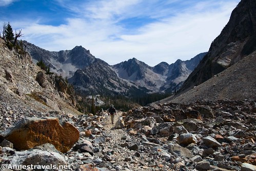
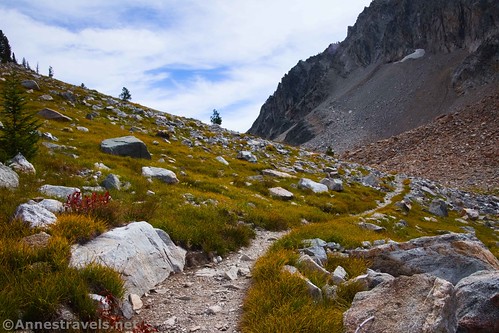
Cross over Iron Creek at mile 3.2; the trail after this was a little difficult to find, but the views immediately improve to include more mountains… and the trail begins to steeply switchback uphill. This was a beautiful but also very strenuous section of trail!

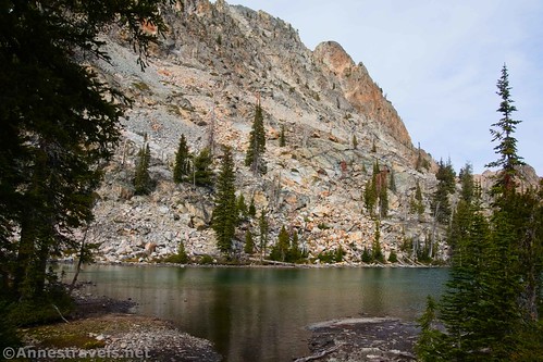
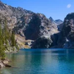
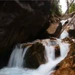
Meet up with the trail to Alpine Lake on the left at mile 4.0. This is a very worthy quarter mile (each way) side-trek if you have time and energy (it’s quite the trail down and back up). The views of Alpine Lake are totally lovely.
There is a fair amount of room along the shore to roam. So if you’re looking for an 8.5 mile RT trail, it would be worth it. But for even better views and mountains, keep switchbacking upward on the main trail.
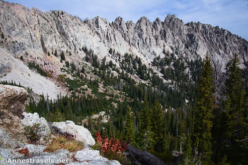
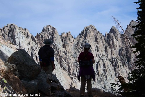
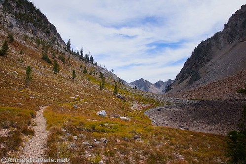
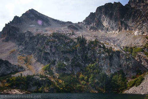
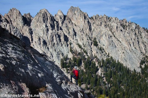
My favorite view along the trail is at mile 4.9 (note that the mileage at this point includes 0.5 miles RT to Alpine Lake and back), where you get fabulous views of a sawtooth-tipped wall of rock at the end of a switchback. It’s almost like the Cirque of Towers collided with the Italian Dolomites, with a bit of the Cascade Range thrown in for good measure. Amazing!
It seemed to take forever to complete the final 0.7 miles up to the junction with the McGown Lakes Trail (on right) and therefore the beginning of Sawtooth Lake. (Maybe I needed lunch, and maybe I wasn’t used to being well over 8,000ft. above sea level. Also, just before this you’ll pass Little Sawtooth Lake.) At the McGown Lakes Trail Junction, turn left. I’m sure you’d get a great view from that path, but we ended up with some pretty spectacular views, so McGown would just have to wait for another day.
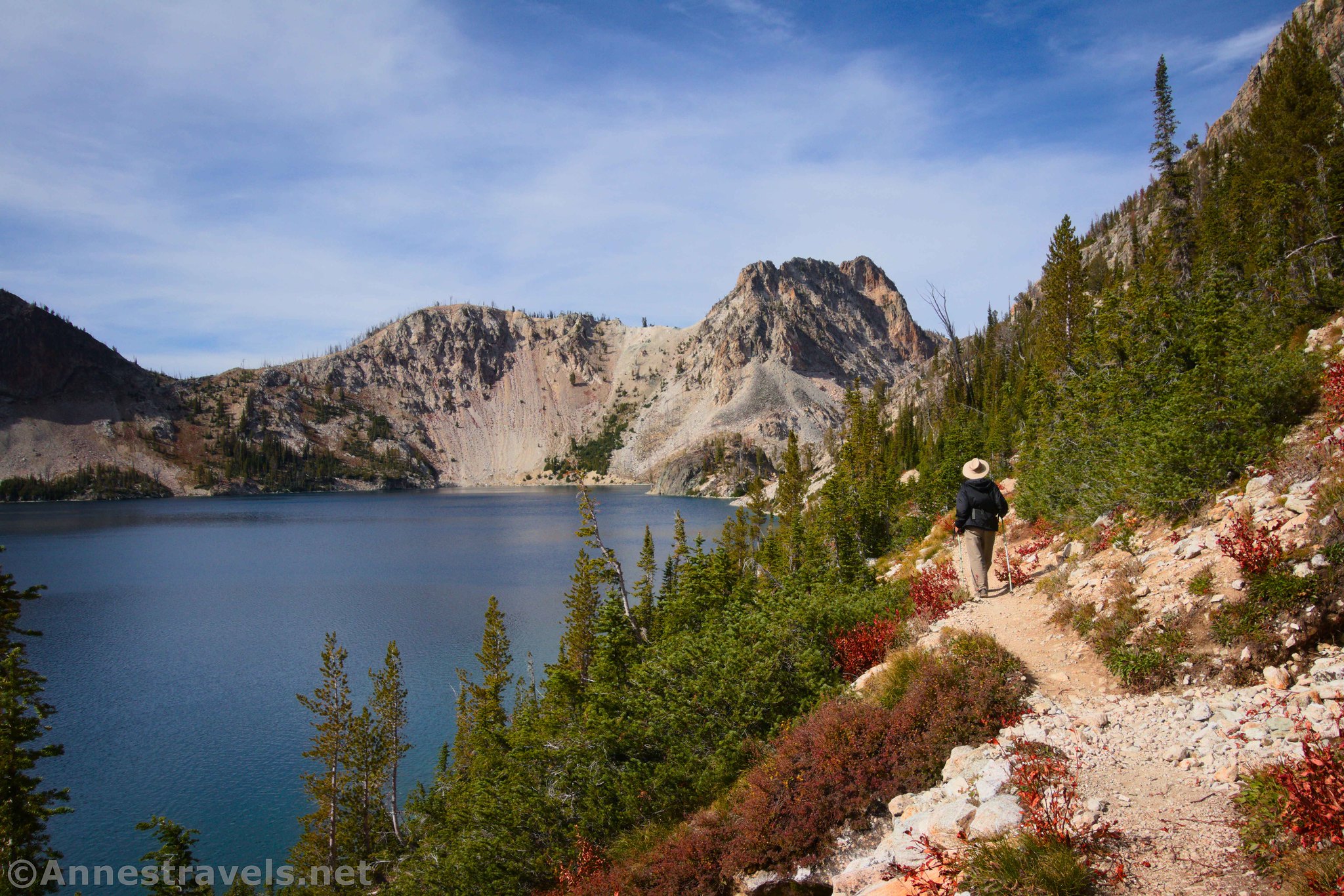
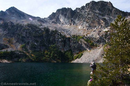
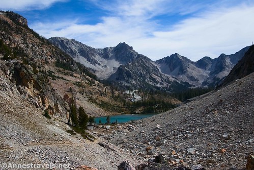
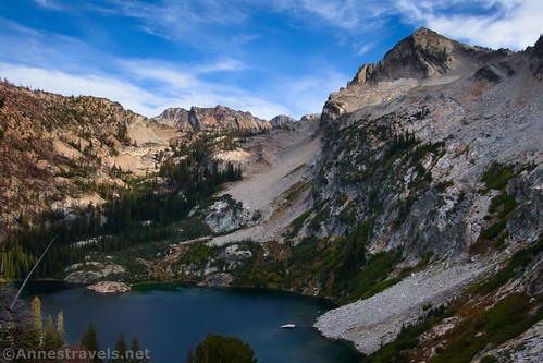
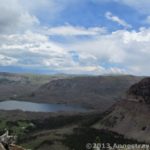
The trail from here works its way up along the wood-choked Sawtooth Lake outlet and then along the left side of Sawtooth Lake beginning about mile 5.8. We scrambled right up a huge rock outcrop to eat lunch. Views were very good if not epic south down Sawtooth Lake to Mt. Regan.

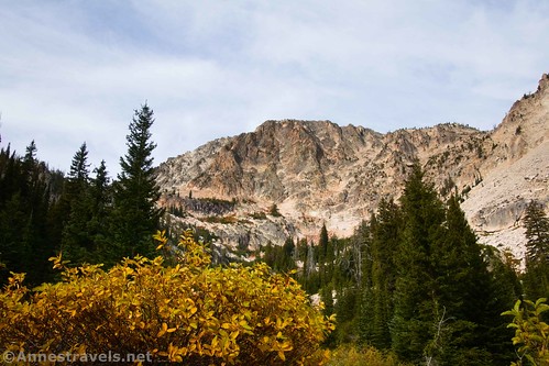
The sun had been out for a few minutes at Alpine Lake and also while we were on the trail, but it had clouded over again. After lunch, the clouds began to part, so we continued along the trail on the shoreline of Sawtooth Lake. (The mountain above the trail is Alpine Lake; I’ve heard that you can climb it, but it looks pretty difficult to me.)
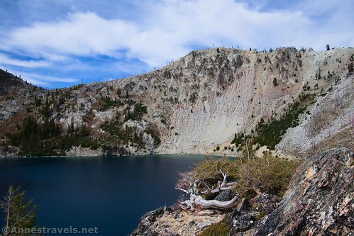
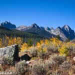
The further we hiked along the shoreline, the more spectacular the views became (and it wasn’t just that the sun came out). Up the trail, down the trail – it didn’t matter which way you looked; it was simply gorgeous!
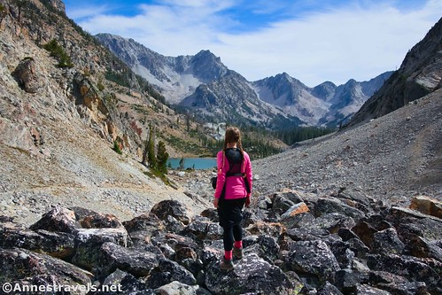
About a mile beyond the McGown Lakes Trail junction, the trail reaches the end of Sawtooth Lake in a meadow area. Near here, another depression is obviously a lake at some times of the year. Views were simply epic from here.

But the trail kept right on twisting and turning to what seemed to be a pass and down the other side. So guess what? We kept on hiking!

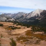
The trail went down to another lake (which as far as I can tell has no official name). Its setting was spectacular. We didn’t get as far as the lake, but we did get maybe halfway down from the pass to the lake. It was just so beautiful.
I know most people stop at Sawtooth Lake. And given that you’re talking an 11.1 mile trek just going to your first view of the lake, well, it makes sense. But if you have the time and energy, it’s so worth hiking along the lakeshore and then over the pass. You won’t regret the views!

But time was getting on, and all of us wanted to be back well before dark. (The days are so short in late September!) So we reluctantly turned back. I can’t say as I hiked back along Sawtooth Lake; it was more of a meander… it’s so hard to race through views like this!

We did make it back to the trailhead before dark, disbelieving that we had actually hiked a total of 13.5 miles that day. Every step was worth it!

Round Trip Trail Length: 11.1 miles to 13.5 miles
Elevation Gain: 2,619ft. (6,724ft. to 8,519ft.)
Facilities: Very primitive restrooms in the parking area; NFS campground adjacent to the parking area; a few picnic tables on the opposite side of the parking area from the restrooms
Fees: None
Trail Notes: Be ready for a strenuous hike; some of the trail is quite good and easy, while other sections are very steep. You don’t have to hike all of the way to the view of the unnamed lake beyond the pass beyond Sawtooth Lake, so it’s easy to shave a couple of miles off your hike if you just aren’t feeling up to more. The area is extremely popular with backpackers. Note that campfires are not allowed within 200ft. of Alpine and Sawtooth Lakes.
Trail 
![]()
![]()
Road ![]()
Signs
Scenery
Would I go 100 miles out of my way for this?
Overall Rating: 

GPS Coordinates for Sawtooth Lake
TH: 44.1986720°, -115.0140390° (44°11.92032′, -115°00.84234′ / 44°11’55.2192″, -115°00’50.5404″) (6,725ft.) (0.0)
Enter Sawtooth Wilderness: 44.1897300°, -115.0302810° (44°11.38380′, -115°01.81686′ / 44°11’23.0280″, -115°01’49.0116″) (6,996ft.) (1.18)
Marshall Junction: 44.1892280°, -115.0316010° (44°11.35368′, -115°01.89606′ / 44°11’21.2208″, -115°01’53.7636″) (7,014ft.) (1.33)
Stanley Junction: 44.1933690°, -115.0385410° (44°11.60214′, -115°02.31246′ / 44°11’36.1284″, -115°02’18.7476″) (7,119ft.) (1.94)
Cross Iron Creek: 44.1882710°, -115.0548450° (44°11.29626′, -115°03.29070′ / 44°11’17.7756″, -115°03’17.4420″) (7,502ft.) (3.22)
Alpine Lake Junction: 44.1840070°, -115.0539960° (44°11.04042′, -115°03.23976′ / 44°11’02.4252″, -115°03’14.3856″) (7,907ft.) (4.04)

Alpine Lake: 44.1829120°, -115.0532550° (44°10.97472′, -115°03.19530′ / 44°10’58.4832″, -115°03’11.7180″) (7,829ft.) (4.25)
View of the Wall: 44.1831980°, -115.0571620° (44°10.99188′, -115°03.42972′ / 44°10’59.5128″, -115°03’25.7832″) (8,178ft.) (4.95)
McGown Junction: 44.1794500°, -115.0629180° (44°10.76700′, -115°03.77508′ / 44°10’46.0200″, -115°03’46.5048″) (8,437ft.) (5.61)
Sawtooth Lake: 44.1776700°, -115.0634130° (44°10.66020′, -115°03.80478′ / 44°10’39.6120″, -115°03’48.2868″) (8,520ft.) (5.85)
Pass: 44.1673290°, -115.0590910° (44°10.03974′, -115°03.54546′ / 44°10’02.3844″, -115°03’32.7276″) (8,512ft.) (6.87)
End: 44.1987030°, -115.0140300° (44°11.92218′, -115°00.84180′ / 44°11’55.3308″, -115°00’50.5080″) (6,725ft.) (13.48)
The gpx file for Sawtooth Lake can be downloaded – please note that this and the GPS Coordinates are for reference only and should not be used as a sole resource when hiking this trail.
Download GPX File size: 261.8 KB Downloaded 331 times
(Note: I do my best to ensure that all downloads, the webpage, etc. are virus-free and accurate; however, I cannot be held responsible for any damage that might result, including but not limited to loss of data, damages to hardware, harm to users, from use of files, information, etc. from this website. Thanks!)
Getting to the Iron Creek Trailhead
From Ketchum, drive north on ID-75N for 60.9 miles. In the town of Stanley, turn left onto ID-21 S (Eva Falls Avenue). After 2.5 miles, turn left onto Forest Road 619 – the road turns to dirt. Stay on this road for 3.1 miles (there are a fair number of dispersed sites along the road; note that camping is allowed only in the official sites). Just before the Iron Creek Campground gate, turn right into the parking area. (This is not necessarily a logical turn, so keep your eyes open for it. And if you drive too far (you wouldn’t be the first), take the campground loop around, turn left on the road, and try for that perfect turn again!)

Today’s Featured Product!
Explore some of the most beautiful hikes in the Sawtooth Mountains and the surrounding area with this guide. Maps, photos, and GPS coordinates combine with trail writeups to give you so many great trails to choose from. Buy your copy here!

Pingback: Sneak Peak: The Rest of the Trip! (SLC, Sawtooths, Utah, Loveland Pass) – Anne's Travels