
A short distance off of I-64 in New River Gorge National Park in West Virginia is an old rails-to-trails. It’s not especially well known or well-traveled, but it is a pretty little ride beside Glade Creek. I started at the south end (upper trailhead) and only went 1.25 miles to a washout, but even this section makes a nice hike or ride since it ends at Kate’s Falls – which is quite impressive, especially after a rain.
Quick Stats

If you want to do this trail from the northern (lower) trailhead, it begins at the Glade Creek Campground. The benefit of the lower route is that the road doesn’t require high clearance or 4×4. However, the trail to Kate’s Falls from the lower trailhead is longer – about 9.6 miles RT. I did the shorter route, so that’s what I’ll be describing in this post.
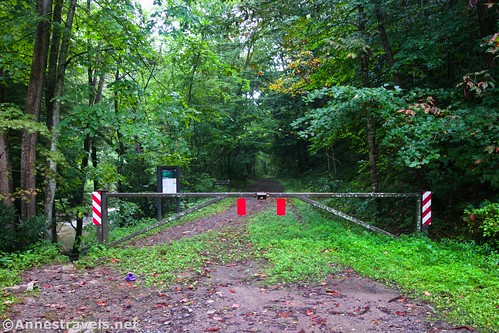
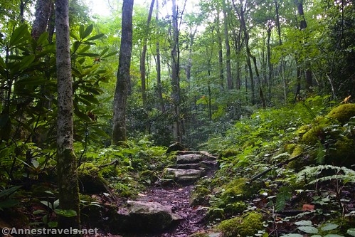
The southern end of the trail (upper trailhead) begins by a locked gate near a sign kiosk. Wheel your bike (or walk) around it to continue up what is obviously a rarely-used gravel road.
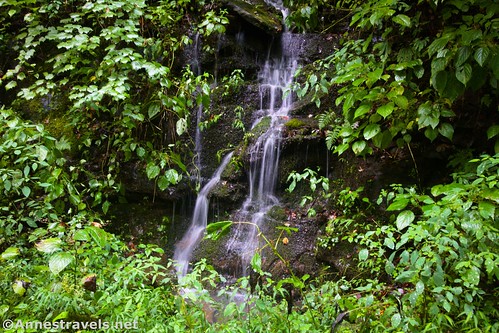
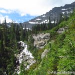
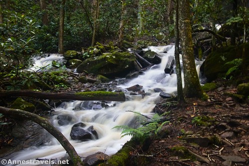
I felt that the gravel made for a pretty bumpy ride. But I couldn’t complain about the scenery. It had rained very heavily two days earlier, and Glade Creek was still filled with water. Even the steep hillside on the right side of the trail was occasionally speckled with small waterfalls.

The morning was very misty. When we started out, I could hear the highway, but it fairly quickly faded as we rode downstream along Glade Creek (note that the trail bed was not especially wet or muddy). When I came back later, I realized that soon after leaving the trailhead we had passed under a huge bridge that carries I-64 across the valley. Well, that would explain why I heard semi-trucks – not that I could see the bridge through the mist!

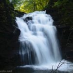
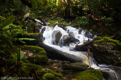
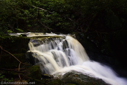
Pass by a small cascade on Glade Creek before reaching the turnoff for Kate’s Falls on the right after 1.25 miles.

There’s nothing saying you can’t take your bikes up to Kate’s Falls, and you may be able to get them partway up the trail. But it fairly quickly turns very rocky and steep. I’d recommend leaving your bikes out of sight of the main trail but also not very far up the side trail. The path climbs up stone stairs through what (in the summer) seems like a jungle of rhododendrons, trees, ferns, and moss.
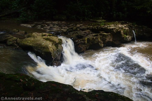
As you climb, you’ll be able to see Kate’s Branch Creek on the left. The cascades below the waterfalls are lovely!

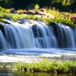
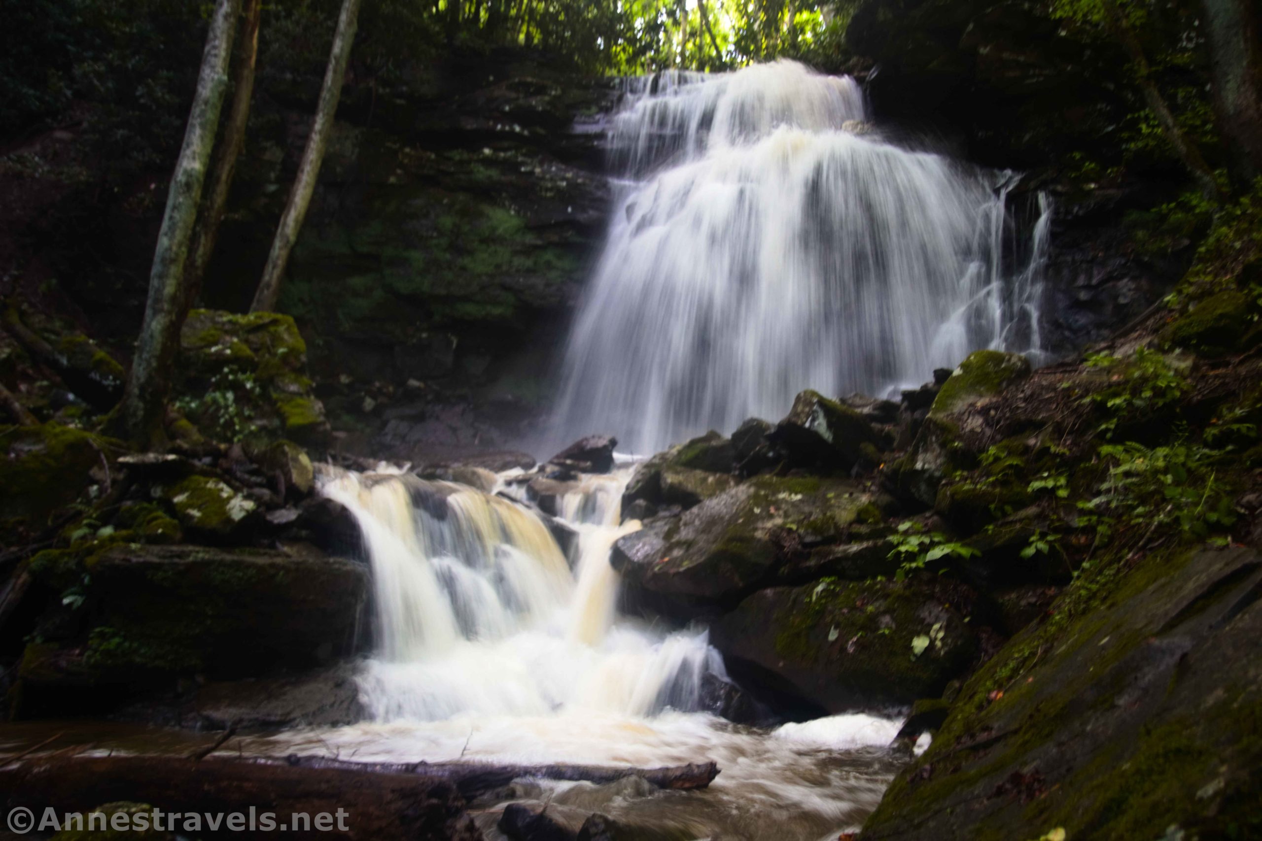
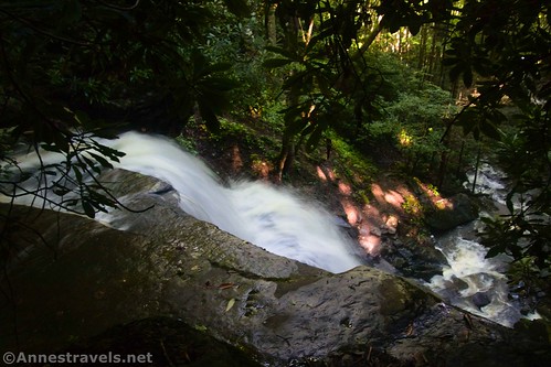
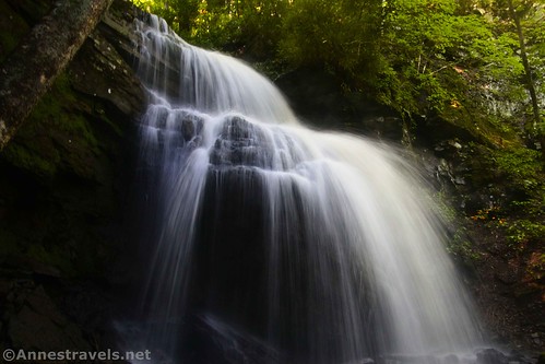
And then suddenly, you’ll get a peek-a-boo of Kate’s Falls through the trees. Keep climbing up to a better viewpoint of the waterfall about mile 1.4.
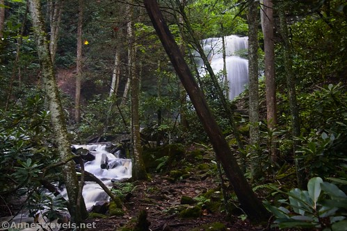
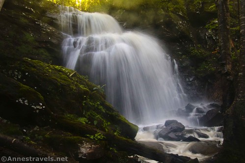
Two days after an extremely heavy rain (plus a few more rain showers the night before), Kate’s Falls was both very beautiful and awe-inspiring. Even in times of lower water, it would be pretty.

Do NOT try to climb up the waterfall from this angle. It is extremely dangerous (more on that in a minute).

We wanted to see the waterfall from a different angle, so we hiked back down to the Glade Creek Trail and turned right (downstream) to cross over Kate’s Branch. The trail here is totally washed out – while we could (and did) scramble across on boulders, taking our bikes didn’t sound like a good idea. (I hear the washout is easier to navigate in times of low water and very dangerous at high flow, so use caution.)
On the other side of the creek, we turned right on social trails up into the trees. Hiking up on this side of the creek was lovely if a total game of ducking and bushwacking rhododendron bushes, not to mention scrambling over fallen logs. You’d better want a pretty crazy adventure!

We reached the north side of Kate’s Falls with my GPS reading 2.2 miles. It was all we’d hoped for and more!
Then we scrambled up a well-defined social trail to the top of the falls. I can’t say I recommend this, as it’s a very steep, slippery route. But you can access the top of the falls as well as one other small cascade.
What we should have done from there was to retrace our steps down to the Glade Creek Trail. However, I thought we could do better by crossing the creek via a log, scrambling up the hill, and coming down on the south side of Kate’s Falls. It turned out to be disastrous; losing the lens cap on my camera and much of the tread on my sneakers were small potatoes compared to the true danger of this route. The hillsides are insanely steep and slippery, and most of the time, I found myself clinging to sketchy rhododendron branches that sometimes broke off in my hands. Just don’t, don’t, don’t try it!!
After making it back to the Glade Creek Trail in (mostly) one piece, we decided to return to the parking area. However, if you can get across the washout, you’re welcome to continue riding or hiking the Glade Creek Trail another 4.6 miles up to the northern (lower) trailhead at the Glade Creek Campground!
Round Trip Trail Length: 2.8 miles out & back to Kate’s Falls. With all of my shenanigans, I went a total of 4.0 miles (or something close to that).
Elevation Gain: My GPS track says 976ft. (1,826ft. to 1,978ft.); I’d guess you could cut a good 284ft. of elevation gain out of that for a total of 688ft., though it’s probably less than that.
Facilities: None, though there’s a campground and likely restrooms at the northern (lower) trailhead
Fees: None

Trail Notes: I highly recommend this hike after a heavy rain (but not if the road is muddy… it’s just too steep to be safe!). The mosses and ferns around the trail up to the falls was truly lovely. Be sure to enjoy the cascades in Glade Creek and also below Kate’s Falls.

Trail 
![]()
![]()
Road ![]()
![]()
Signs ![]()
![]()
Scenery ![]()
![]()
Would I go 100 miles out of my way for this? ![]()
![]()
Overall Rating: ![]()
![]()

GPS Coordinates for the Glade Creek Trail (S TH) to Kate’s Falls
Southern Trailhead: 37.764646,-81.042963 (37°45.87876′, -081°02.57778′ / 37°45’52.7256″, -081°02’34.6668″) (1,947ft.) (0.0)
Kates Falls Junction: 37.775655,-81.032852 (37°46.53930′, -081°01.97112′ / 37°46’32.3580″, -081°01’58.2672″) (1,852ft.) (1.22)
Kates Falls: 37.775499,-81.031400 (37°46.52994′, -081°01.88400′ / (1,913ft.) (1.42)
Far side of creek: 37.775254,-81.031314 (37°46.51524′, -081°01.87884′ / 37°46’30.9144″, -081°01’52.7304″) (1,940ft.) (2.17)
End: 37.764789,-81.042944 (37°45.88734′, -081°02.57664′ / 37°45’53.2404″, -081°02’34.5984″) (1,941ft.) (3.99)
North Trailhead (at Glade Creek Campground: 37.8271221°, -081.0105706° (37°49.62733′, -081°00.63424′ / 37°49’37.6395″, -081°00’38.0543″)
The gpx file for the Glade Creek Trail from the southern (upper) trailhead to Kate’s Falls can be downloaded – please note that this and the GPS Coordinates are for reference only and should not be used as a sole resource when hiking this trail.
Download GPX File size: 63.9 KB Downloaded 487 times
(Note: I do my best to ensure that all downloads, the webpage, etc. are virus-free and accurate; however, I cannot be held responsible for any damage that might result, including but not limited to loss of data, damages to hardware, harm to users, from use of files, information, etc. from this website. Thanks!)

Getting to the Glade Creek Trailhead
Southern trailhead:
From I-64, take Exit 129A (just Exit 129 if on I-64W) toward Shady Spring. If on I-64W, turn left to pass under the highway. If on I-64E, merge right. After 0.8 miles, turn left onto Scott Branch Road – it has a street sign, but otherwise, it’s fairly unassuming. Follow the road 1.6 miles down, down, down to the parking area just after crossing the bridge over Glade Creek.
Note that getting to this trailhead requires high clearance; 4×4 is also a good idea. I did it in my 2WD, high clearance van. The biggest issue is that the road is exceedingly steep – so getting down it and then back up can be… exciting.
Northern trailhead:
From I-64, take Exit 124 toward US-19. The exit will drop you onto Joe L Smith Drive. After 1.7 miles, continue straight when the road changes names to E Beckley Bypass for another 1.6 miles. Turn right onto WV-41N (Stanaford Road) for 4.5 miles; turn right onto WV-41 N (Johnstown Road) for another 3.9 miles. At the turn to cross the bridge over the New River, take a slight right onto Glade Creek Road (in other words, don’t cross the bridge). The trailhead should be at the end of the road after 5.6 miles.
Or from Fayetteville, drive south on US-19. About 10 miles later, turn left onto Wood Mountain Road, then take an immediate right onto WV-61S (basically, you turn left off of the highway and then make a right onto what looks like a frontage road). After 2.7 miles, turn left to stay on WV–61S for another 4.4 miles. Turn left onto WV-41N (Johnstown Road) for 3.9 miles. At the turn to cross the bridge over the New River, take a slight right onto Glade Creek Road (in other words, don’t cross the river). The trailhead should be at the end of the road after 5.6 miles.

Today’s Featured Product!
Bike and hike the New River Gorge with this book. Written by a man who has spent much of his life exploring the trails and cliffs of the park, it has many gems within its pages. Buy your copy here!