

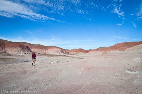
My top favorite trail I did in Petrified Forest National Park last fall was the Wilderness Route Loop through the Painted Desert. Actually, it’s not a trail at all; it’s loosely connected GPS coordinates that take you to some delightful and interesting features (mostly petrified wood). So I’d have to say that my favorite trail was the Blue Forest Route (also a route, but mostly with a defined trail). But for sheer exploration, discovery, and the thrill of losing your way multiple times, the Wilderness Route can’t be beat!
Quick Stats
The trail starts from the parking area by the Painted Desert Inn. Signs talk about the dangers of the Wilderness Route as well as Onyx Bridge. We ended up hiking down to Onyx Bridge first and then retracing our steps to where we’d dropped into Lithodendron Wash. (For the sake of time and blog space, I’m not going to detail that here – you’re welcome to follow the directions I gave on my Onyx Bridge post down the trail, past the historic bridge, and across the plain to the wash.)

You’ll also want to ask at the visitor center for the Wilderness Route handout. Unlike most of the off-trail routes in the park, I haven’t been able to find this printout online. But it’s super helpful, with pictures, GPS coordinates, and more.

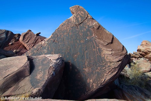
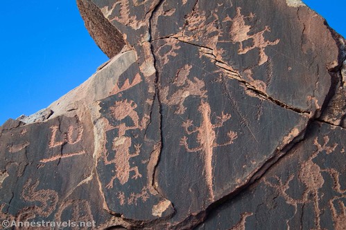
The first stop on the Wilderness Loop is Flat Iron Panel. From where the “trail” reaches Lithodendron Wash, don’t drop into the wash; instead, turn left to walk over to a pile of rocks. It’s not hard to find.

There was so much variety on this panel! Swirls, depictions, geometric designs, even a few more modern inscriptions (not that I’m happy about those). Remember to keep your distance and don’t touch the boulder.

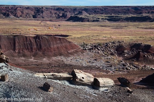
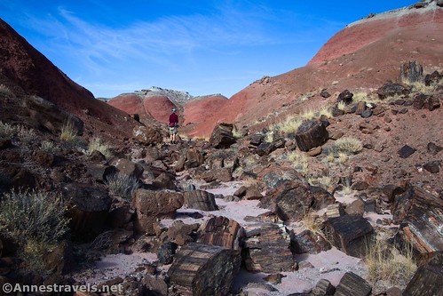
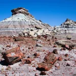
After enjoying the rock art, walk north to drop into the wash. This is where things got tricky, and once we were good and lost, I was glad I was trying to follow GPS coordinates! We walked left and took the first major drainage on our right (north) to the left of a gray cliff. There was a ton of petrified wood in this drainage as well as these cool rocks. (All was good so far.)
Just like the directions told us, we took the middle drainage when the wash split in three. We even saw the log the printout mentioned that still had its roots.
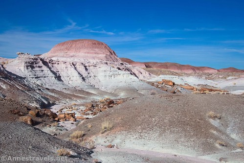
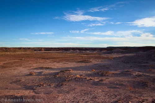
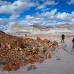
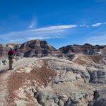
We scrambled up to the mesa near the head of the wash and saw the red badlands on our right, just like the printout said. But then things got weird. Looking at the directions now, I can see exactly how we went wrong. Because despite saying where Gregory Stump is, the directions don’t actually tell you how to find it! So that’s how we became lost.
Not very lost, though, thankfully! We turned left (our backs to the red hills) and walked with the GPS coordinates plugged into my GPS, mostly sticking to the top of the mesa just above the canyon (which means we had to go inland a bit when the canyon did the same). Sure enough, about a mile from Flat Iron Panel, there was the stump!

It’s so cool. And the views around it are great! In fact, while some of the other features along the loop are much prettier and more expansive, I’d say the stump was the coolest thing we saw all day.
We retraced our steps back to near where we exited the canyon, then turned left to follow the red hills to the next feature – Angel’s Garden.
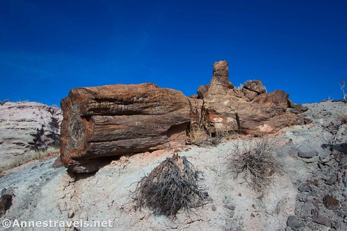
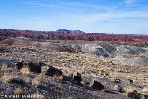
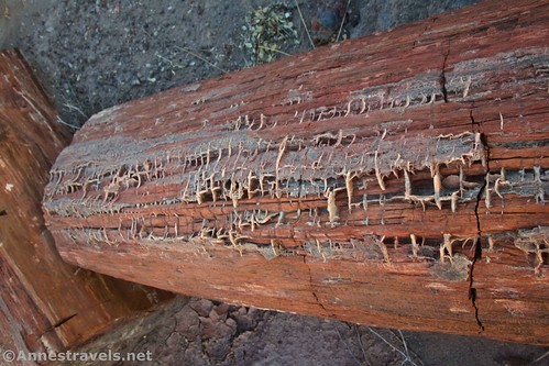
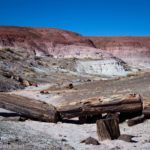
The garden is a collection of petrified wood. It’s quite impressive, and much of the wood is yellowish in color.
I hear that there are “twin logs” – to me, it was all pretty neat to see.
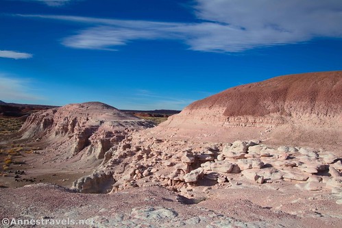
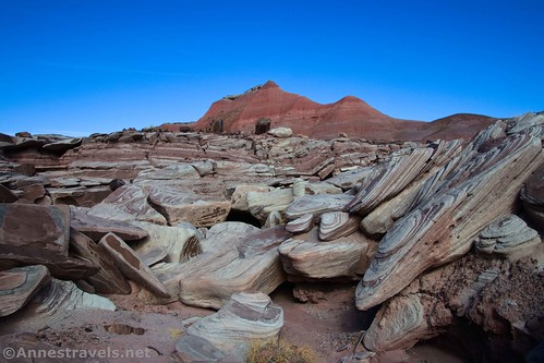
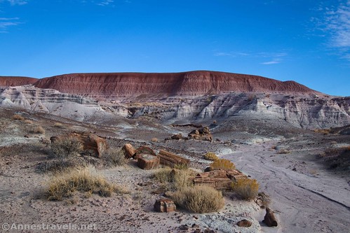
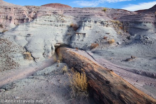
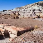
From here, keep walking with the red badlands on your right. We tried to take a shortcut to go straight between Angel’s Garden and the next deposit of petrified wood (I hadn’t read yet that the NPS asks you not to scramble over the badlands – oops!), and it was a disaster. For one thing, going straight between the two takes you up and down and over multiple hills. For another thing, the badlands are steep and covered with little stones – it’s incredibly dangerous to try and climb them. So really, just follow the edges of the badlands! You’ll have a much pleasanter, faster hike. Plus, you’ll get to see cool formations like these:
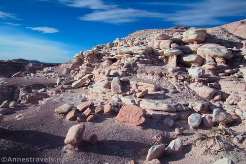
The route sometimes is a little narrow or requires mild scrambling. But it’s still a far cry better than trying to go over the badland formations.
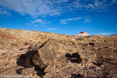
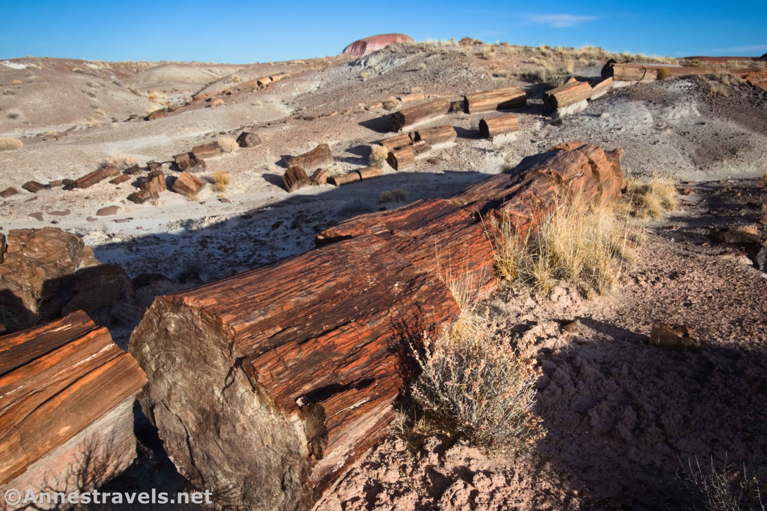
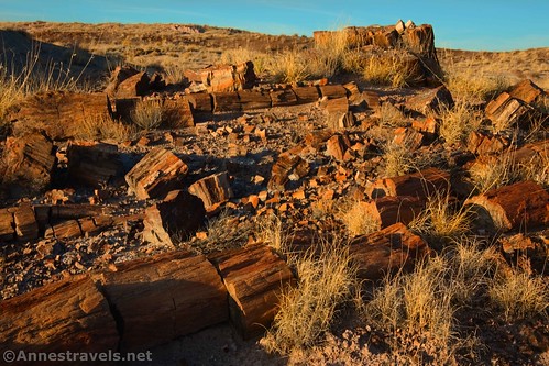
About 1.5 miles from Angel’s Garden, you will come into the Chalcedony Forest. This was my favorite deposit of petrified wood. It’s often black or dark-colored, and there’s simply so much of it! The area also lent itself well to photography (that’s probably the real reason it was my favorite!)

Turn right (east-northeast) to begin the return part of the loop. Keep the badlands more or less on your right, though you’ll probably pass through a hole in a “wall” of badlands before dropping onto a white plain. Walk across this plain to an old, wooden, horse-drawn road grader. It’s about 0.3 miles between the Chalcedony Forest and the road grader.
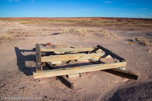
No one is sure who owned the grader or how it got here. It’s possible that it was part of the equipment used by Herbert Lore (who built the Painted Desert Inn and a network of roads through the Painted Desert in the 1920s), but it could also have been left by another enterprising individual.
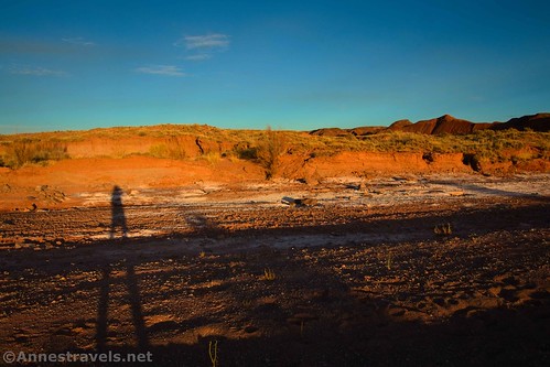
From here, turn right to head south – keep the red badlands on your right (is this sounding like a broken record?) Ahead of you will be a long arm of badlands that stretches east toward Lithodendron Wash. You want to stay right to avoid the worst of the sand and yet eventually walk around this arm. After the arm, walk straight south (stay right to avoid more sand) to Lithodendron Forest about a mile from the road grader.
By this time, the sun was beginning to set (we hadn’t exactly gotten an early start, and then we’d wasted quite a bit of time getting lost – and finding interesting things along the way), so we didn’t spend much time in Lithodendron Forest. There was a nice deposit of petrified wood and even a few interesting types that I hadn’t seen elsewhere on the hike, but I felt that it was the weakest of the petrified wood areas along the loop.
We picked up a small wash and followed it south to drop into the much bigger Lithodendron Wash. Turn right to follow Lithodendron Wash back downstream.
About 0.4 miles after dropping into Lithodendron Wash, the wash for Onyx Bridge goes off on the right. So if you want to add this to the loop, it’s a great side-trail (even if you’ve seen better stuff along the loop already). From here, follow the wash or else go cross-country to cut the gooseneck. The important thing is to not miss the trail (on left) out of the wash that will take you back to the parking area – the butte that has Flat Iron Panel is a great landmark!
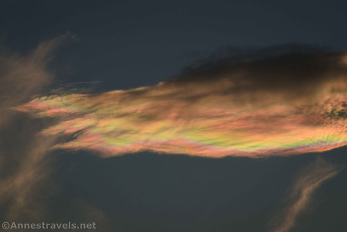
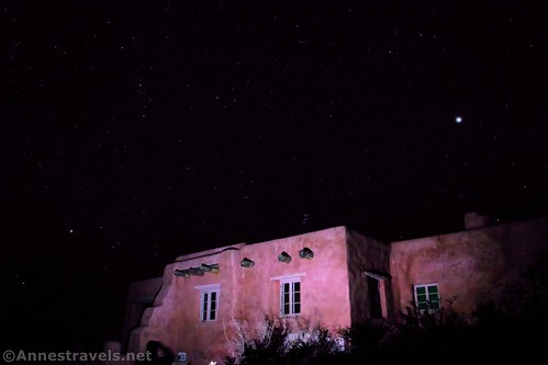
Darkness fell as we crossed the plain back toward the trail that would take us up to the Painted Desert Inn. I’m glad we hurried down the wash – while I could have navigated back via GPS, it was much more enjoyable to do it with at least some daylight. But at least I got to try out light painting on the Painted Desert Inn after we got back!
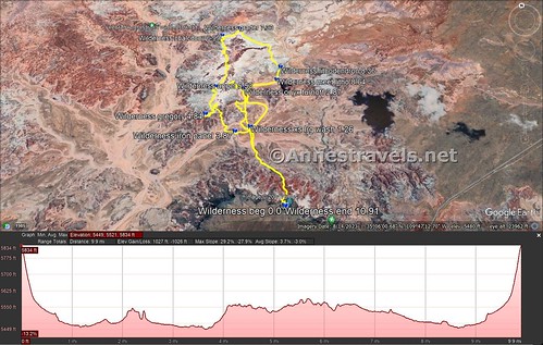
Round Trip Trail Length: My entire trek was 10.9 miles, but that included hiking to Onyx Bridge and then back to start the loop at Flat Iron Panel. Without that little side jaunt, it would be closer to 8.7 miles. The NPS says that the entire loop is only 7 miles. Adding on Onyx Bridge only as a side trek off of the loop would bring the total up to 9.3 miles.
Elevation Gain: I had a total elevation gain of 1,027ft. (5,449ft. to 5,834ft.)
Facilities: Restrooms and water at the Painted Desert Inn
Fees: $25/vehicle, valid 7 days. America the Beautiful National Parks & Federal Lands Passes and Petrified Forest Annual Passes are also accepted.
Trail Notes: There is no trail for the majority of this hike. You may occasionally see faint paths where others have hiked, but that’s about it after leaving the badlands below the trailhead (there is a faint trail or two across the plain to Lithodendron Wash/Flat Iron Panel). So you’re on your own out here. Be ready to self-rescue. You should not try this hike unless you’re very well-versed in off-trail travel. I was very glad for my GPS, and I’ve done a lot of off-trail hiking in the desert. Do not dig or uncover anything (historical or otherwise), even if it’s partially above ground. Don’t climb the badlands any more than necessary (I’ve already talked about that, but in case you missed it, besides damaging the landscape, it’s also very dangerous). Don’t take anything more than photos and don’t deface anything – being able to explore this area is a privilege, and even one hiker being inconsiderate could force the NPS to keep all hikers from ever being allowed to do it again. Don’t be *that* hiker!

Trail 
![]()
![]()
![]()
![]()
Road ![]()
Signs ![]()
![]()
![]()
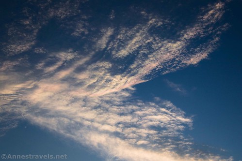
Scenery
Would I go 100 miles out of my way for this?
Overall Rating: 
![]()
GPS Coordinates for the Wilderness Loop
TH: 35.0836960°, -109.7890040° (35°05.02176′, -109°47.34024′ / 35°05’01.3056″, -109°47’20.4144″) (5,831ft.) (0.0)
Bridge: 35.0916810°, -109.7907890° (35°05.50086′, -109°47.44734′ / 35°05’30.0516″, -109°47’26.8404″) (5,505ft.) (0.76)
Lithodendron Wash: 35.0982330°, -109.7911610° (35°05.89398′, -109°47.46966′ / 35°05’53.6388″, -109°47’28.1796″) (5,463ft.) (1.26)
I am including the Onyx Bridge coordinates, even though they have little to do with this loop
Square butte: 35.1038110°, -109.7909850° (35°06.22866′, -109°47.45910′ / 35°06’13.7196″, -109°47’27.5460″) (5,482ft.) (1.93)
Onyx split: 35.1072420°, -109.7916470° (35°06.43452′, -109°47.49882′ / 35°06’26.0712″, -109°47’29.9292″) (5,511ft.) (2.21)
Onyx split: 35.1080330°, -109.7921570° (35°06.48198′, -109°47.52942′ / 35°06’28.9188″, -109°47’31.7652″) (5,526ft.) (2.28)
Onyx Bridge: 35.1086010°, -109.7921990° (35°06.51606′, -109°47.53194′ / 35°06’30.9636″, -109°47’31.9164″) (5,542ft.) (2.35)
Turnoff for Onyx Bridge in Lithodendron Wash: 35.1063330°, -109.7906640° (35°06.37998′, -109°47.43984′ / 35°06’22.7988″, -109°47’26.3904″) (5,496ft.) (2.87)
Back to the Wilderness Loop…
Flat Iron Panel: 35.0978120°, -109.7939770° (35°05.86872′, -109°47.63862′ / 35°05’52.1232″, -109°47’38.3172″) (5,475ft.) (3.87)
Gregory Stump: 35.1018770°, -109.7985780° (35°06.11262′, -109°47.91468′ / 35°06’06.7572″, -109°47’54.8808″) (5,561ft.) (4.84)
Angel’s Garden: 35.1074770°, -109.7957730° (35°06.44862′, -109°47.74638′ / 35°06’26.9172″, -109°47’44.7828″) (5,537ft.) (5.53)
Chalcedony Forest: 35.1200920°, -109.7924850° (35°07.20552′, -109°47.54910′ / 35°07’12.3312″, -109°47’32.9460″) (5,562ft.) (6.99)
Road Grader: 35.1214620°, -109.7884170° (35°07.28772′, -109°47.30502′ / 35°07’17.2632″, -109°47’18.3012″) (5,575ft.) (7.33)
Lithodendron Forest: 35.1099610°, -109.7825380° (35°06.59766′, -109°46.95228′ / 35°06’35.8596″, -109°46’57.1368″) (5,519ft.) (8.36)
Meet Lithodendron Wash: 35.1071750°, -109.7839980° (35°06.43050′, -109°47.03988′ / 35°06’25.8300″, -109°47’02.3928″) (5,498ft.) (8.64)
End: 35.0836610°, -109.7890140° (35°05.01966′, -109°47.34084′ / 35°05’01.1796″, -109°47’20.4504″) (5,831ft.) (10.91)

The gpx file for the Wilderness Loop (with my trek to Onyx Bridge) can be downloaded – please note that this and the GPS Coordinates are for reference only and should not be used as a sole resource when hiking this trail.
Download GPX File size: 181.7 KB Downloaded 523 times
(Note: I do my best to ensure that all downloads, the webpage, etc. are virus-free and accurate; however, I cannot be held responsible for any damage that might result, including but not limited to loss of data, damages to hardware, harm to users, from use of files, information, etc. from this website. Thanks!)
Getting to the Wilderness Route Loop Trailhead
From I-40, take Exit 311 for Petrified Forest National Park. At the end of the exit ramp, turn north, following signs for Petrified Forest. You’ll enter the park almost immediately. Drive 2.1 miles to turn right into the parking area marked for Kachina Point and the Painted Desert Inn.
From the southern part of Petrified Forest National Park, drive north on the park road. The left turn into the parking area for Kachina Point and the Painted Desert Inn (the trailhead) is 23.8 miles north of the southern visitor center (Rainbow Forest Museum / the parking lot through which the main road travels).

More Hikes in Arizona!
52 hikes for the 52 weekends of the year – complete with a guide to the seasons! Explore some of the best trails that Arizona has to offer. Buy your copy here!

One response to “The Painted Desert’s Wilderness Loop”
[…] we tried to follow the Wilderness Route. I finally gave up and used the excellent GPS coordinates given by the park (available as a […]