I’m always on the lookout for cool new hikes in my favorite national parks. So I was super excited to read about hiking to Jicarilla Point, well west of Hermit’s Rest, on the rim of the Grand Canyon. It seemed like the perfect way to spend a cold and sunny afternoon before hiking the South Kaibab Trail the next day. It would also be an adventure, since there’s no trail much of the way and it’s not exactly in the main part of the park (we’re talking 15+ miles of dirt roads just to get to the “trailhead”). But it was totally gorgeous, so I’ll try to make it easier for you to find the point than what little I could gather off of the internet before we left home.
Quick Stats
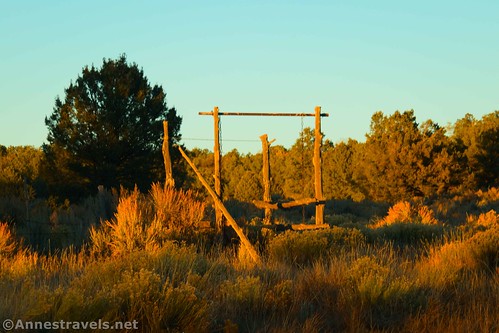
The “trailhead” – such as it is – for Jicarilla Point is at Homestead Tank, deep in either Ancestral Footprints of the Grand Canyon National Monument (did you know that existed? I didn’t, but then again, it was only 3.5 months old at that point) or Kaibab National Forest. It’s accessible by high clearance (maybe low clearance if you go super slow) via a network of dirt roads south (or west) of Grand Canyon Village. Park near the corral and head east and north up the dirt road (technically, you can drive this, but I’d want some serious 4×4 to try it – 0.25 miles from Homestead Tank is a wet and technical section that didn’t look fun at all).
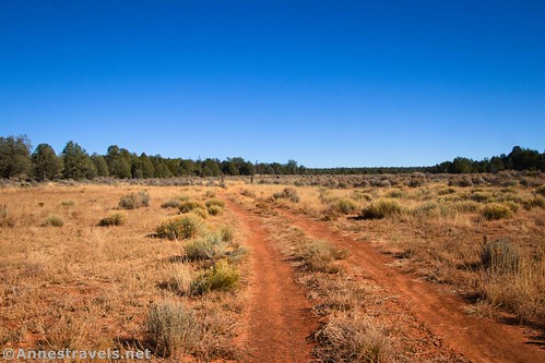
Follow the dirt road (technically Forest Service Road 2509) for 0.9 miles, staying left on the main road. For the most part, the road wanders through meadows and sparse forests; it would be hot on a summer (or even spring/fall) afternoon. The junction at mile 0.9 is marked by a large jumper tree with a sign on it (exactly what the sign means, I’m not sure). While you could technically turn right and get to the same place (hike up the road, staying left at all junctions, to the Boundary Road; then left on the Boundary Road to the beginning of the Old Road), we turned left.
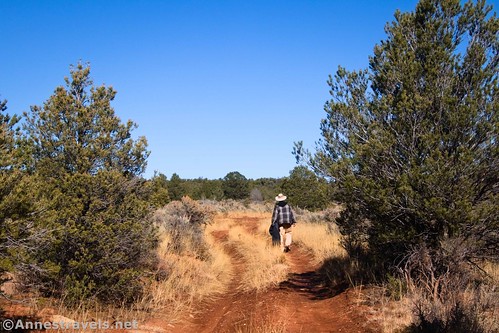
The road after this is surrounded by more trees but finally enters a meadow 0.9 miles beyond the junction (mile 1.8). I turned right here, following animal trails, washes, and whatever footprints I could find in a generally north-northeast direction. I hear (though not on infallible authority) that if I’d walked another tenth of a mile (or so) up the road beyond the meadow, a road would have gone off on the right that I could have taken to the next landmark. Oh well!

One thing is for certain: About 0.5 miles after leaving the road in the meadow, we came to the fence that marks the boundary of Grand Canyon National Park. Just on the other side of this fence is the Boundary Road – you can’t miss it!

One of my group members grew up on a farm, so he showed us all how to climb through the fence. (“You should have seen my very proper grandmother in her flowered skirts, out there climbing through barbed wire fences…”) This included taking off some packs, passing them through or over the fence, and then climbing through ourselves.

Once upright again, and with our backpacks in their proper places, we turned right for a short distance before turning left into the trees. On our way back, we found an easier route, so I’ll describe that route:

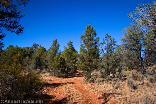
Basically, you’re looking for the remains of an old road on the left (north) side of Boundary Road. The Old Road (capitalized just so that I can differentiate it from the rest of the roads in the area) meets Boundary Road at 36.0943430°, -112.3264720°. Turn left onto this old road and do your best to follow it generally northeast toward the rim of the Grand Canyon. If you can’t find the Old Road, just head generally northeast on whatever path seems best to you.

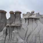
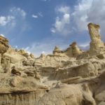
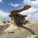
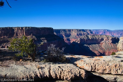
The Old Road ends in what was obviously once a parking area (I think it’s in the vicinity of 36.1059903°, -112.3147523°, but I forgot to take a coordinate so don’t trust this one). At this point, it’s a “simple” matter of scrambling north (and just slightly east) down into a ravine, up the other side, and out to Jicarilla Point. But before you do that, you might want to scramble down the ravine (left/west) to its end at the cliff so that you can see Jicarilla Bridge, a natural bridge (arch) on the very edge of the canyon.

The bridge can be difficult to photograph since it’s at the end of the ravine, where the water drops down the cliff into a side canyon. But with some careful scrambling, you should be able to see it pretty well.

From Jicarilla Bridge, head north (and slightly east), keeping the cliffs on your left. When you get out to the far end of the mesa, you’ve reached Jicarilla Point!

We ended up at a viewpoint just slightly left (west) of the official point, because the views seemed to be better from there. But in all honesty, you can scramble around (carefully – there are no guardrails!) until you find a view that suits your fancy.
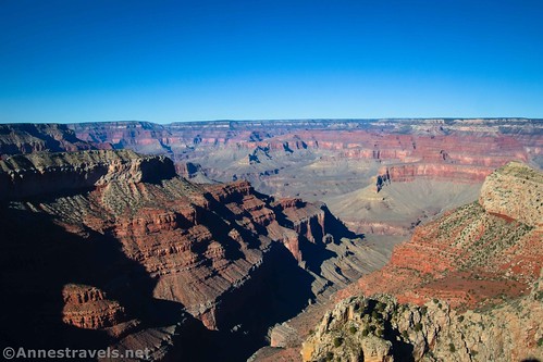
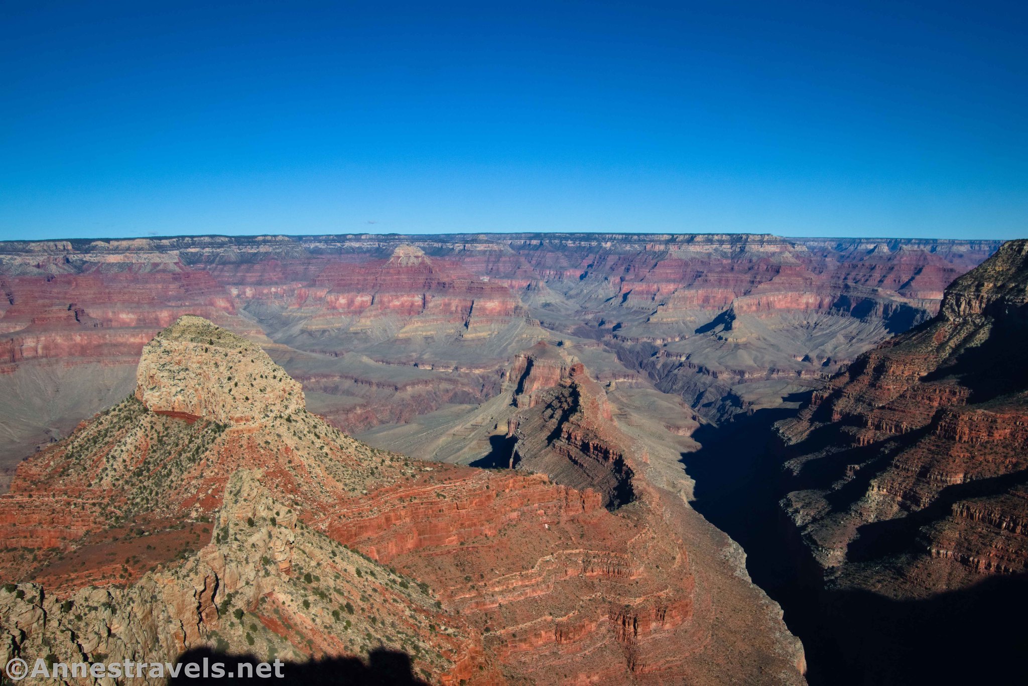
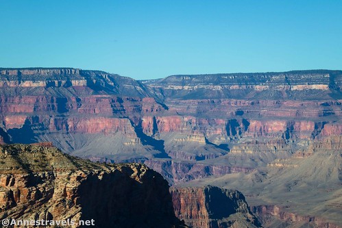
The views from Jicarilla Point are fantastic! It’s a very different view than any other part of the canyon, even different from Hermit’s Rest. I totally loved looking down into the side canyons, across to all of the canyon formations, and downcanyon (left/west) to buttes and cliffs that most people don’t ever get to see.

Daylight was fading, and there was no way we wanted to hike back in the dark (besides wanting to get to bed early… we were planning to be up by about 3:30am for our R2R hike the next day). So we headed back. But it was a great view that I’m so glad we were brave enough to find! For another great hike that also visits three other points in this stretch of the Grand Canyon, visit The American Southwest Website.

Round Trip Route Length: I went 7.75 miles
Elevation Gain: Varies, but it’s around 500ft. (6,228ft. to 6,580ft.)
Facilities: None, though there are some dispersed spots along the various dirt roads (I think Homestead Tank is on private property, so you shouldn’t camp there)
Fees: None unless you come in through Grand Canyon National Park (I’ll talk about that below)

Trail Notes: I relied heavily on my GPS and coordinates I’d printed off the internet for this hike. While it could be done without coordinates, it would be difficult and probably take extra time trying to scout, especially between the Boundary Road and Jicarilla Bridge. Besides the roads, there are no trails to follow. There are also no railings, cell service, or signs telling you to be careful. So you’d better watch yourself out here, be ready to self-rescue, and be extremely comfortable bushwacking and off-trail hiking through a forest before attempting it. I didn’t see any big animals, but I did find elk prints – try not to scare these animals!

Trail 
![]()
![]()
![]()
![]()
Road ![]()
![]()
![]()
Signs ![]()
![]()
![]()
![]()
Scenery
Would I go 100 miles out of my way for this?
Overall Rating: ![]()
![]()

GPS Coordinates for Jicarilla Point
TH Homestead Tank: 36.0720870°, -112.3399460° (36°04.32522′, -112°20.39676′ / 36°04’19.5132″, -112°20’23.8056″) (6,233ft.) (0.0)
Turn off road in meadow: 36.0903040°, -112.3341260° (36°05.41824′, -112°20.04756′ / 36°05’25.0944″, -112°20’02.8536″) (6,358ft.) (1.79)
Boundary fence: 36.0949770°, -112.3275570° (36°05.69862′, -112°19.65342′ / 36°05’41.9172″, -112°19’39.2052″) (6,439ft.) (2.33) (Did you know? Before this we were in Baaj Nwaavjo I’tah Kukveni – Ancestral Footprints of the Grand Canyon National Monument! Did you know the monument even existed??)
Jicarilla Bridge: 36.1077230°, -112.3132980° (36°06.46338′, -112°18.79788′ / 36°06’27.8028″, -112°18’47.8728″) (6,471ft.) (3.76)
Jicarilla Point: 36.1082080°, -112.3120630° (36°06.49248′, -112°18.72378′ / 36°06’29.5488″, -112°18’43.4268″) (3.87)
Better Viewpoint: 36.1087730°, -112.3122570° (36°06.52638′, -112°18.73542′ / 36°06’31.5828″, -112°18’44.1252″) (6,379ft.) (3.9)
Boundary Road (end of old road): 36.0943430°, -112.3264720° (36°05.66058′, -112°19.58832′ / 36°05’39.6348″, -112°19’35.2992″) (6,437ft.) (5.36) (I think the old parking area may be around 36.10599030471985, -112.31475225945634)
Return to the road: 36.0902730°, -112.3341220° (36°05.41638′, -112°20.04732′ / 36°05’24.9828″, -112°20’02.8392″) (6,358ft.) (5.97)
Junction & sign on tree (Kaibab National Forest boundary?): 36.0794570°, -112.3288430° (36°04.76742′, -112°19.73058′ / 36°04’46.0452″, -112°19’43.8348″) (6,292ft.) (6.80)
End: 36.0721220°, -112.3399010° (36°04.32732′, -112°20.39406′ / 36°04’19.6392″, -112°20’23.6436″) (6,233ft.) (7.75)

The gpx file for my hike to Jicarilla Point can be downloaded – please note that this and the GPS Coordinates are for reference only and should not be used as a sole resource when hiking this trail. Also note that this is an unedited track, so it has my attempt to bushwack as well as the Old Road route.
Download GPX File size: 108.4 KB Downloaded 365 times
(Note: I do my best to ensure that all downloads, the webpage, etc. are virus-free and accurate; however, I cannot be held responsible for any damage that might result, including but not limited to loss of data, damages to hardware, harm to users, from use of files, information, etc. from this website. Thanks!)
Getting to the Jicarilla Point Trailhead (Homestead Tank)
For the southern route (no entry fee):
You want to turn west onto a dirt road at 35.9902219, -112.1236597 – it is signed as Moqui Dr. (This road is 0.7 miles south of the South Entrance Station on AZ-64 and 0.9 miles north of the final traffic circle in Tusayan). Moqui Dr. turns left almost immediately, swinging south, then swings north again after passing the Apache Stables. It swings east, then north, then east again – stay on the main road. After 4.9 miles, stay left at a major junction (36.0092289, -112.1904297) to cross the railroad tracks. (Skip the next paragraph to continue the directions.)
From Grand Canyon Village:
Follow the signs for the Kennels (not the easiest thing; use the park map/directions). On your way to the kennels, you’ll cross the railroad tracks. Turn left just after crossing the tracks. Now ignore the signs for the kennels and drive about 3.7 miles. At this point, you must turn left to cross the tracks again; drive 0.5 miles to the next junction (36.0092289, -112.1904297). Take a sharp right to cross the railroad tracks one more time. (Continue with the directions below.)

If coming from either direction:
After crossing the railroad tracks, the road swings sharply north before heading east again. Stay on the main road. About 11.3 miles from the railroad tracks, turn right toward an old ranching operation. Park on the north side of the watering hole; you want to hike on the old road that passes through the fence and heads generally east. Technically, you could drive this road at least to the tree junction and probably beyond. However, a rutted offset section about a quarter mile beyond where we parked would stop most vehicles, so walking is probably a better option.

Today’s Featured Product!
If you’re looking for hikes adventures – above and beyond the tourist trails – in the Grand Canyon, this is a good guide. It covers more than 100 trails within and around the canyon. Buy your copy here!