
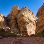
There are a few places in southern Utah that are known to mimic the famous swirls of the Wave – but that don’t require a very difficult-to-obtain permit. One is the Beehive Trail just north of Page (nicknamed “the New Wave” – post coming soon), and another is the Nautilus on the White House Road near the Paria Ranger Station south of US-89. Of the two, the Beehive Trail probably mimics the Wave better, but I loved exploring around the Nautilus. Besides just the shell formation, the rocks in the area provided plenty of camera-fodder in the form of swirls, stripes, streaks, and more.
Quick Stats

The Nautilus is in a strange position – driving just down the road, you need an (expensive to me) permit to explore the famous Buckskin Gulch. But there isn’t even a fee for the Nautilus (at least at this point!) It’s famous enough among internet researchers, but not enough so to demand its own parking area more than a pulloff near the wash.

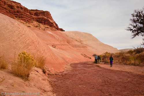
The trail to the Nautilus begins as walking up the second major wash as you’re driving down (south on) the White House Road. (Don’t park in the wash – should a flash flood come up, you don’t want your vehicle to be in the way! Two small parking areas are available just north of (before you reach) the wash – they look like sandy pulloffs). After a tenth of a mile, you can see the remains of an old fence that once stretched across the wash.
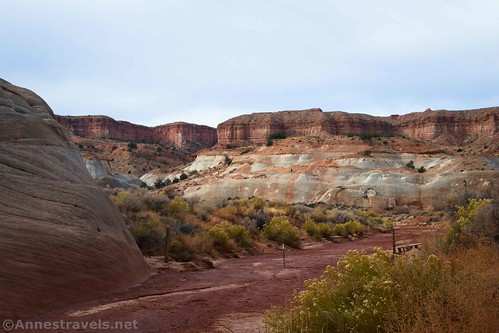
Hiking up the wash is easier if it’s rained recently. Otherwise, the sand can be deep, making the hiking more difficult. Most people seem to stay to one edge or the other of the wash for easier walking, though in general you’ll need to stay in the wash rather than on the bank.
On my first visit to the Nautilus, I was so busy admiring the canyon that I almost missed what I’d come so far to see! A social trail on the right at mile 0.4 goes off on the right (east), rising up to the Nautilus formation.

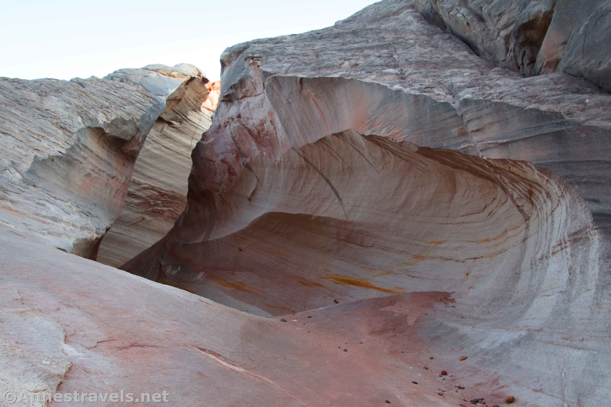
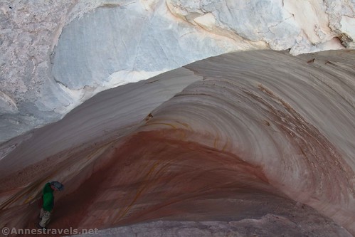
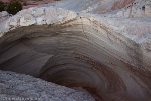
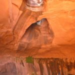
And a cool formation it is! The trail takes you right to the place where you can scramble up inside, then climb the sloping, swirling passageway to the top. It’s just so cool!

The Nautilus was named for the shell of that name, not for Capt. Nemo’s ship. I can see how scrambling up the swirl would be a bit like entering a shell!

Use care as you climb – the rock is often slippery with sand from hikers’ boots and shoes. I didn’t have too much trouble, but I was wearing good hiking boots (affiliate link).

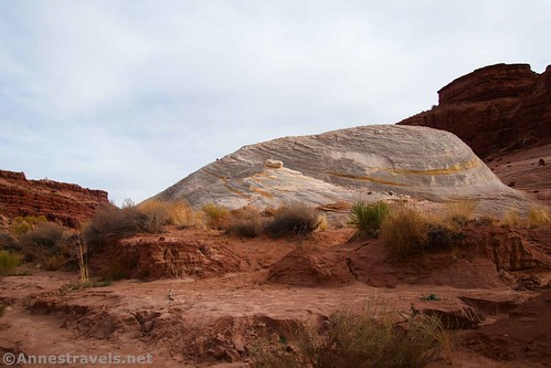
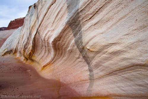
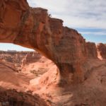
Once on top, you can explore around either side of the Nautilus – I recommend checking out both sides, as they’re both very pretty, with swirls and lines in the rocks. Here’s a photo from the right (north) side…
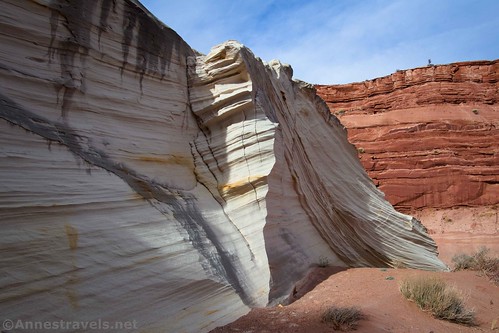
And here’s a photo from the left (south) side.
When you’ve had your fun, retrace your steps down the wash back to the parking area. Except that, on my second visit, I wasn’t pushing daylight (only snow flurries), so I explored the surrounding area. I’m going to do another post just for those photos, as there were so many stripes, a couple of canyons, and photogenic places to discover.

Feel free to explore to your heart’s content, as long as you can find your way back to your vehicle!
Round Trip Route Length: I went 1.2 miles on my first venture, which was when I basically saw the Nautilus, went around both sides, and returned. If you only hiked to the Nautilus and back, it would be closer to 0.9 miles RT.
Elevation Gain: 170ft. (4,303ft. to 4,356ft.)
Facilities: None at the trailhead. Restrooms are available at the White House Trailhead, and visitor information is available (in season) at the Paria Contact Station at the beginning of the White House Road.
Fees: None

Trail Notes: Be aware that there is no trail. You’re just following the wash looking for the formation. Use care as you scramble, as the sand and rocks are slippery. This is a favorite with families, so expect to share it with others on a nice day.

Trail 
![]()
![]()
![]()
Road ![]()
![]()
Signs ![]()
![]()
![]()
![]()
Scenery ![]()
Would I go 100 miles out of my way for this? ![]()
Overall Rating: ![]()
![]()
GPS Coordinates for The Nautilus
TH (in wash): 37.0864290°, -111.8915850° (37°05.18574′, -111°53.49510′ / 37°05’11.1444″, -111°53’29.7060″) (4,302ft.) (0.0)
Fence: 37.0869690°, -111.8894270° (37°05.21814′, -111°53.36562′ / 37°05’13.0884″, -111°53’21.9372″) (4,309ft.) (0.13)
Leave wash: 37.0898540°, -111.8864860° (37°05.39124′, -111°53.18916′ / 37°05’23.4744″, -111°53’11.3496″) (4,319ft.) (0.42)
The Nautilus: 37.0897660°, -111.8860150° (37°05.38596′, -111°53.16090′ / 37°05’23.1576″, -111°53’09.6540″) (4,337ft.) (0.45)
End: 37.0864150°, -111.8915670° (37°05.18490′, -111°53.49402′ / 37°05’11.0940″, -111°53’29.6412″) (4,303ft.) (1.19)

The gpx file for The Nautilus can be downloaded – please note that this and the GPS Coordinates are for reference only and should not be used as a sole resource when hiking this trail.
Download GPX File size: 21.2 KB Downloaded 460 times
(Note: I do my best to ensure that all downloads, the webpage, etc. are virus-free and accurate; however, I cannot be held responsible for any damage that might result, including but not limited to loss of data, damages to hardware, harm to users, from use of files, information, etc. from this website. Thanks!)

Getting to the Nautilus Trailhead
From Page, AZ, drive north on US-89N to cross the Glen Canyon Dam. About 28.2 miles after crossing the dam, turn left on the White House Road, following signs for the Paria Contact Station. Instead of turning right into the station, continue left past the dumpsters down the dirt road. The parking area for the Nautilus will be on the right (west) after 1.5 miles. To get to the trailhead, continue walking down into the wash; turn left (upstream).

From Kanab, UT, drive east on US-89S. Pass the visitor center; 42.4 miles later, turn right onto the White House Road, which may be signed for the Paria Contact Station. Instead of turning right into the station, continue left past the dumpsters down the dirt road. The parking area for the Nautilus will be on the right (west) after 1.5 miles. To get to the trailhead, continue walking down into the wash; turn left (upstream).

Today’s Featured Product!
Nearly 60 hikes are featured in this book, covering canyons, vistas, arches, waterfalls, springs, and so much more! Buy your copy here.


2 responses to “The Nautilus: An Easier Wave?”
[…] were still a few more hours of daylight, so we drove over to the short hike to the Nautilus (named for the seashell, not Captain Nemo). It was an incredible and very fun […]
[…] we stopped at the Nautilus again (it’s just that cool!) and explored around enough to see so many fun lines in the nearby […]