If you’ve ever seen photos of Cuyahoga Valley National Park, you’ve probably seen one (or both!) of the two famous waterfalls in the park: Brandywine Falls and Blue Hen Falls. My first and foremost plan when visiting the park for the first time was to see the more popular of the two: Brandywine Falls. Close to a parking lot and quite scenic, it’s the one destination that’s almost universally visited by everyone visiting Cuyahoga Valley National Park.
Quick Stats
Note: Some of the links in this post are affiliate links. If you click one and purchase something, I may earn a small commission without an extra cost to you.

However, there was one big problem. The road and parking area for Brandywine Falls were being resurfaced during my visit, meaning that I literally could not get to the trailhead. Not to be put off that easily, I parked at the Stanford House and took the Stanford Trail over to Brandywine Falls. Sure, it was about 2.25 miles longer than if I’d been able to park at the official trailhead, but at least I got to see it! And while I was at it, I also hiked the Gorge Trail – a very worthwhile loop if you happen to be at Brandywine Falls.
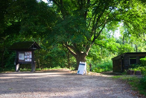
I pulled into the Stanford House parking lot (actually just a gravel lot behind the barn) very early one morning in August. I was the second car in the lot, though two more pulled in while we ate breakfast.

The trailhead is marked by an old chicken coop (if you can call a building that massive a “coop!”). There’s also a signboard kiosk.

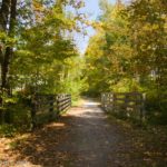
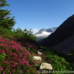
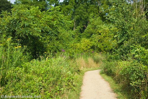
The trail descends immediately down into a meadow. In August, the wildflowers here were outstanding. From the stones on the trail, I’d guess this section is pretty wet in the spring.

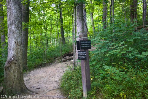
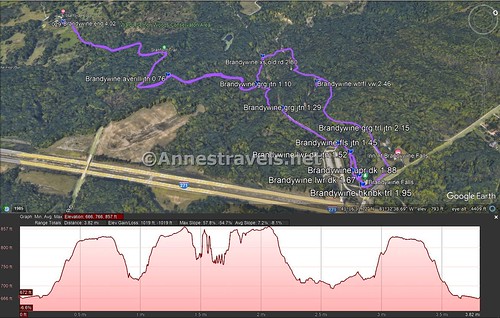
Faster than you’d wish, the trail turns into the forest. The trail rises and falls with the terrain to the junction with the trail to Averill Pond 0.75 miles from the trailhead. Turn right, following the sign for Brandywine Falls.
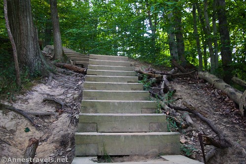
The next junction is at mile 1.1 – the Brandywine Gorge Trail. The sign says that turning left will take you to Brandywine Falls in 1 mile, while turning right will get you there in 0.25 miles. We turned right to climb a steep set of wooden steps to a second junction with the Gorge Trail at mile 1.3 (it’s called Stanford Trail on the sign and looks like an old road). Turn right toward Brandywine Falls.

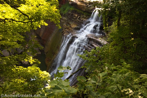
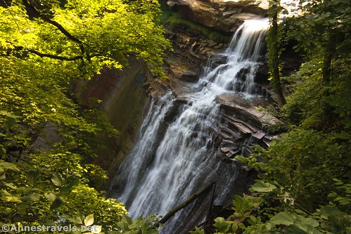
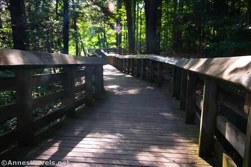
And then, at last, 1.45 miles from the Stanford House Trailhead, you’ll come to the junction for Brandywine Falls (this is just below the Brandywine Falls parking area). Turn left down the boardwalk 0.05 miles to a junction. We decided to go to the lower viewpoint first, so we went left down the stairs and boardwalk for 0.15 miles. The cliffs are impressive, but the viewing area has a very nice view of Brandywine Falls.
We were very early hikers, so only one other group (a mom and daughter, I think) was there ahead of us. They left after a few minutes, so we had our choice of photography spots. That’s not all that frequent from what I can tell!

There are two things you can’t really tell from my photographs. The first is that it’s actually somewhat hard to see the entirety of the falls because of the tree branches, etc. Not impossible, just difficult. The second thing you can’t really tell is that morning is most definitely not the time to visit Brandywine Falls! The light is directly behind the falls, meaning that to get the falls bright enough, you’ll wash out the top of the falls and the bridge beyond. I compensated a bit with RAW file format and editing after the fact, but even that wasn’t perfect.

Several other groups were coming down, so to give them space, we walked back up the stairs, turned left, and arrived at the upper viewpoint of Brandywine Falls. It’s more of a top-down view. It’s quite nice, but it also suffers from too many tree branches. However, the light issue wasn’t as much of a problem, which was nice. (Note: The upper viewpoint is the only one of the viewpoints that is even close to accessible – the lower one has quite a few stairs.)
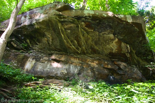
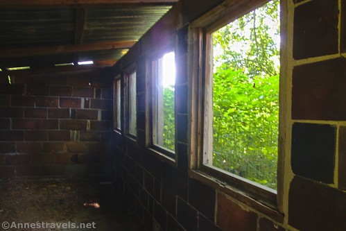
We continued along the trail and pretty quickly found some stairs down and around the ruins of a building that once generated power from the waterfall. This part of the trail also gives you an up-close view of the lip of Brandywine Falls.

After this, things got a little tricky if you want to complete the Gorge Trail (which I highly recommend – it’s a very pleasant hike). You’ll come to the Bike & Hike Trail (paved) and you want to turn left (the sign is marked as the Brandywine Gorge Trail) to cross over Brandywine Creek above the falls. The trail then turns back downstream (I felt like I was in the backyard of a bed & breakfast) to a trail junction about 0.3 miles from the upper viewing area of Brandywine Falls. Again, take the left trail – I believe it is marked as the Stanford Trail at this point.

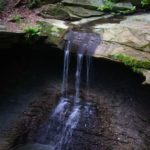
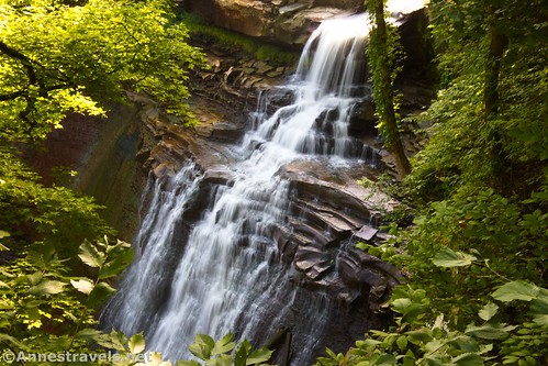
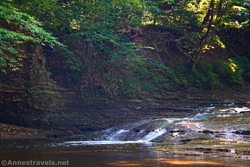
From here, the trail descends through the forest above Brandywine Creek. About 0.3 miles after the last junction, we spotted a trail/watercourse that went down to the creek. We followed it and scrambled down a steep embankment to a pretty little view of a small waterfall. Sadly, my camera lens was having issues at that moment, so my aperture was way off (thus too small a depth of field for the pictures, thus they’re a bit blurry in the backgrounds). I tried to get some pictures anyway and mostly succeeded.
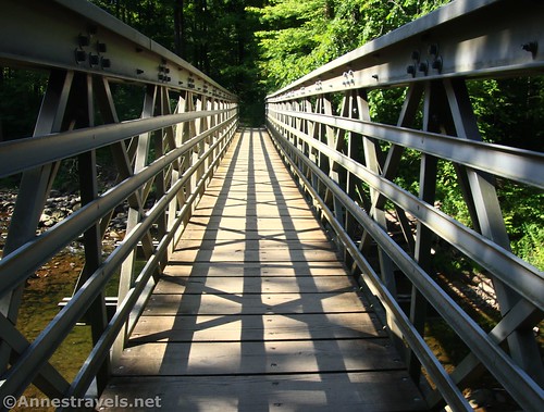
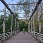
Keep walking on the main trail to the point where it turns left to cross an impressive bridge back over Brandywine Creek. Fairly soon after this, the trail crosses an old road (don’t turn onto the road) about mile 2.8 (about 0.3 miles beyond where we went down to the creek). A tenth of a mile later, the trail meets up with what was the first of the two Gorge Trail Junctions. Turn right for 1.1 miles back to the Stanford House Trailhead.
Note: If you’re trying to do just Brandywine Falls and the Gorge Loop, begin at the trailhead at the far end of the Brandywine Falls parking area. The junction onto the boardwalk should be quite soon (marked at 1.45 miles in the GPS coordinates). Follow the directions (above) to the lower and upper viewing areas of Brandywine Falls, then past the ruins, then follow the instructions for the Gorge Trail. Cross the impressive bridge and the old road; when you come to the Gorge Trail Junction a tenth of a mile beyond the old road, turn left 2 tenths of a mile to the old road; turn right about 0.15 miles back to where you’d ascend up to the parking area. Total mileage would be in the neighborhood of 1.8 miles RT.

Round Trip Trail Length: 4.0 miles lollipop loop from the Stanford Trailhead. Brandywine Falls and the Gorge Loop alone are about 1.8 miles RT.
Elevation Gain: 1,019ft. (666ft. to 857ft.) (Gorge Trail: 651ft. (693ft. to 867ft.)
Facilities: Brand new restrooms should be available at the Brandywine Falls Trailhead
Fees: None

Trail Notes: I do recommend the Gorge Trail; however, unless you like walking through the woods, I can’t say that I was terribly fond of the Stanford Trail. It was a lot of ups and downs for not a lot of gain. Photography of Brandywine Falls is probably best later in the day, when the falls don’t have the sun behind them. However, getting to the falls early means it will be much quieter with fewer people around. Multiple stairs are required to get to the lower viewing area. Note that wedding photography is not permitted without a permit (so sayeth a sign on the boardwalk). At times, the park may close the boardwalks due to dangerously icy or slippery conditions. It’s said that Brandywine Falls was named for a small town (Brandywine) that no longer exists.
Trail 
![]()
Road ![]()
Signs
Scenery ![]()
![]()
Would I go 100 miles out of my way for this? ![]()
![]()
Overall Rating: ![]()

GPS Coordinates for Stanford Trail-Brandywine Falls-Gorge Trail Loop
Stanford House Trailhead: 41.2710750°, -081.5559170° (41°16.26450′, -081°33.35502′ / 41°16’15.8700″, -081°33’21.3012″) (669ft.) (0.0)
Averill Junction: 41.2735900°, -081.5475920° (41°16.41540′, -081°32.85552′ / 41°16’24.9240″, -081°32’51.3312″) (827ft.) (0.76)
Gorge Trail Junction: 41.2762690°, -081.5453290° (41°16.57614′, -081°32.71974′ / 41°16’34.5684″, -081°32’43.1844″) (731ft.) (1.10)
Gorge Trail Junction: 41.2763250°, -081.5430810° (41°16.57950′, -081°32.58486′ / 41°16’34.7700″, -081°32’35.0916″) (826ft.) (1.29)
Falls Junction: 41.2768990°, -081.5402280° (41°16.61394′, -081°32.41368′ / 41°16’36.8364″, -081°32’24.8208″) (849ft.) (1.45)
Lower deck junction: 41.2770990°, -081.5397260° (41°16.62594′, -081°32.38356′ / 41°16’37.5564″, -081°32’23.0136″) (831ft.) (1.52)
Lower deck: 41.2768270°, -081.5387100° (41°16.60962′, -081°32.32260′ / 41°16’36.5772″, -081°32’19.3560″) (791ft.) (1.67)
Upper deck: 41.2767270°, -081.5389000° (41°16.60362′, -081°32.33400′ / 41°16’36.2172″, -081°32’20.0400″) (823ft.) (1.88)
Hike and Bike Trail Junction: 41.2765840°, -081.5381760° (41°16.59504′, -081°32.29056′ / 41°16’35.7024″, -081°32’17.4336″) (836ft.) (1.95)
Gorge Trail: 41.2780260°, -081.5403360° (41°16.68156′, -081°32.42016′ / 41°16’40.8936″, -081°32’25.2096″) (844ft.) (2.15)
Waterfall view: 41.2783260°, -081.5442740° (41°16.69956′, -081°32.65644′ / 41°16’41.9736″, -081°32’39.3864″) (712ft.) (2.46)
Cross old road: 41.2773500°, -081.5472850° (41°16.64100′, -081°32.83710′ / 41°16’38.4600″, -081°32’50.2260″) (711ft.) (2.80)
Return to the Stanford Trail: 41.2763680°, -081.5454320° (41°16.58208′, -081°32.72592′ / 41°16’34.9248″, -081°32’43.5552″) (728ft.) (2.94)
End: 41.2710700°, -081.5558570° (41°16.26420′, -081°33.35142′ / 41°16’15.8520″, -081°33’21.0852″) (669ft.) (4.02)
The gpx file for the Stanford Trail, Brandywine Falls, and the Gorge Trail can be downloaded – please note that this and the GPS Coordinates are for reference only and should not be used as a sole resource when hiking this trail.
Download GPX File size: 63.6 KB Downloaded 480 times
(Note: I do my best to ensure that all downloads, the webpage, etc. are virus-free and accurate; however, I cannot be held responsible for any damage that might result, including but not limited to loss of data, damages to hardware, harm to users, from use of files, information, etc. from this website. Thanks!)
Getting to the Stanford Trailhead
If coming from the south on I-271N, take Exit 12 toward OH-303 and Richfield/Peninsula. At the bottom of the ramp, turn right onto OH-303E for 300ft. and then take a quick left onto Stine Road for 1.6 miles. Turn left onto Riverview Road for a mile, then right onto Boston Mills Road for only a quarter mile. Take a left onto Stanford Road; after half a mile, turn right up the driveway for the Stanford House. It looks quite posh, but if you go past the house and beyond the barn, a gravel parking area is available for hikers.
If coming from the north on I-271S, take Exit 18B for OH-8; merge onto OH-8S. After 2.6 miles, take the exit toward Boston Mills Road for 0.4 miles. Turn right onto E Hines Hill Road for 3.2 miles, then take a slight right onto Boston Mills Road. A tenth of a mile later, take a quick right onto Stanford Road. After half a mile, turn right up the driveway for the Stanford House. It looks quite posh, but if you go past the house and beyond the barn, a gravel parking area is available for hikers.

From I-80W (from the east on the Ohio Turnpike), take Exit 180 for OH-8. Keep right, following the signs for Boston Mills Road/Hines Hill Road, then turn left onto E Boston Mills Road for 3.2 miles. Take a slight right onto Stanford Road. After half a mile, turn right up the driveway for the Stanford House. It looks quite posh, but if you go past the house and beyond the barn, a gravel parking area is available for hikers.

From I-80E (from the west on the Ohio Turnpike), take Exit 173 toward I-77 (Cleveland/Akron). However, after half a mile, keep right, following signs for OH_21/Richfield. Turn right onto OH-21 S/Breksville Road (signs may point toward Richfield/I-77). After 0.7 miles, turn left onto Boston Mills Road. Drive 1.1 miles, turn left onto Black Road for 0.1 mile, and then turn right onto Boston Mills Road. Continue another 2.9 miles and then turn left onto Stanford Road. After half a mile, turn right up the driveway for the Stanford House. It looks quite posh, but if you go past the house and beyond the barn, a gravel parking area is available for hikers.
This Week’s Featured Product!
This book covers most of the trails in Cuyahoga Valley National Park – and it’s one of the few of its kind. The guide covers hiking trails, bicycle trails, ski trails, and horse trails for the most comprehensive guide possible. Buy your copy here!