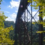

If you only have time for one hike in New River Gorge National Park, I’d recommend that it be Long Point. Better than the Endless Wall Trail, better than Sandstone Falls, Long Point offers spectacular views of the New River Gorge Bridge and the gorge, itself. I had the great opportunity of taking the trail in the early evening after a small storm, so we pretty much had the viewpoint to ourselves along with the great evening light.
Quick Stats
Note: Some of the links in this post are affiliate links. If you click one and purchase something, I may earn a small commission without an extra cost to you.
The trailhead has a fairly large parking lot, but I expect it could be busy on summer weekends. A storm had blown through as we ascended from the bottom of the gorge via the old road, so that had hurried any hikers along back to their vehicles. A watery sun was showing through as we picked up our daypacks and headed down the trail.
The first part of the path is more or less wheelchair accessible since it leads to a viewpoint over the marsh. We took a quick look before continuing on the main trail.

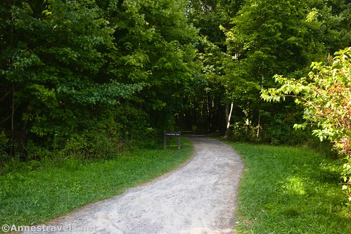
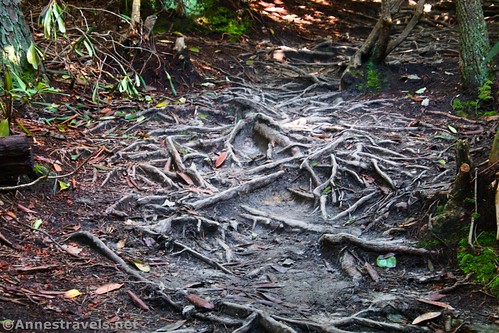
For the most part, the Long Point Trail is wide and easy to walk. Some sections have roots, puddles (remember the rainstorm?), and a few bridges over wet patches. The entire trail is in the forest, so don’t expect scenic views.

After 0.4 miles, the Fayetteville Trail crosses the Long Point Trail. Be sure to follow the signs and continue straight. The Butcher Branch Trail strikes off on the right (east) 0.25 miles later. Again, follow the signs to go straight (left) toward Long Point.

About 1.3 miles from the trailhead, the trail comes to a bike rack. It’s an odd thing to see in the middle of nowhere in the woods! The trail seems to go straight here, past the sign that says “No Bicycles Beyond This Point.” It actually turns left to enter a tunnel of rhododendrons. Someone must keep this trail clear, since even my 6ft. companion didn’t have to duck!

The trail after the bicycle rack is much narrower and is often riddled with roots. It also suddenly seems to have a hankering to travel downhill. The good news is that it’s only another 0.3 miles to Long Point!

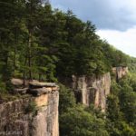
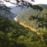
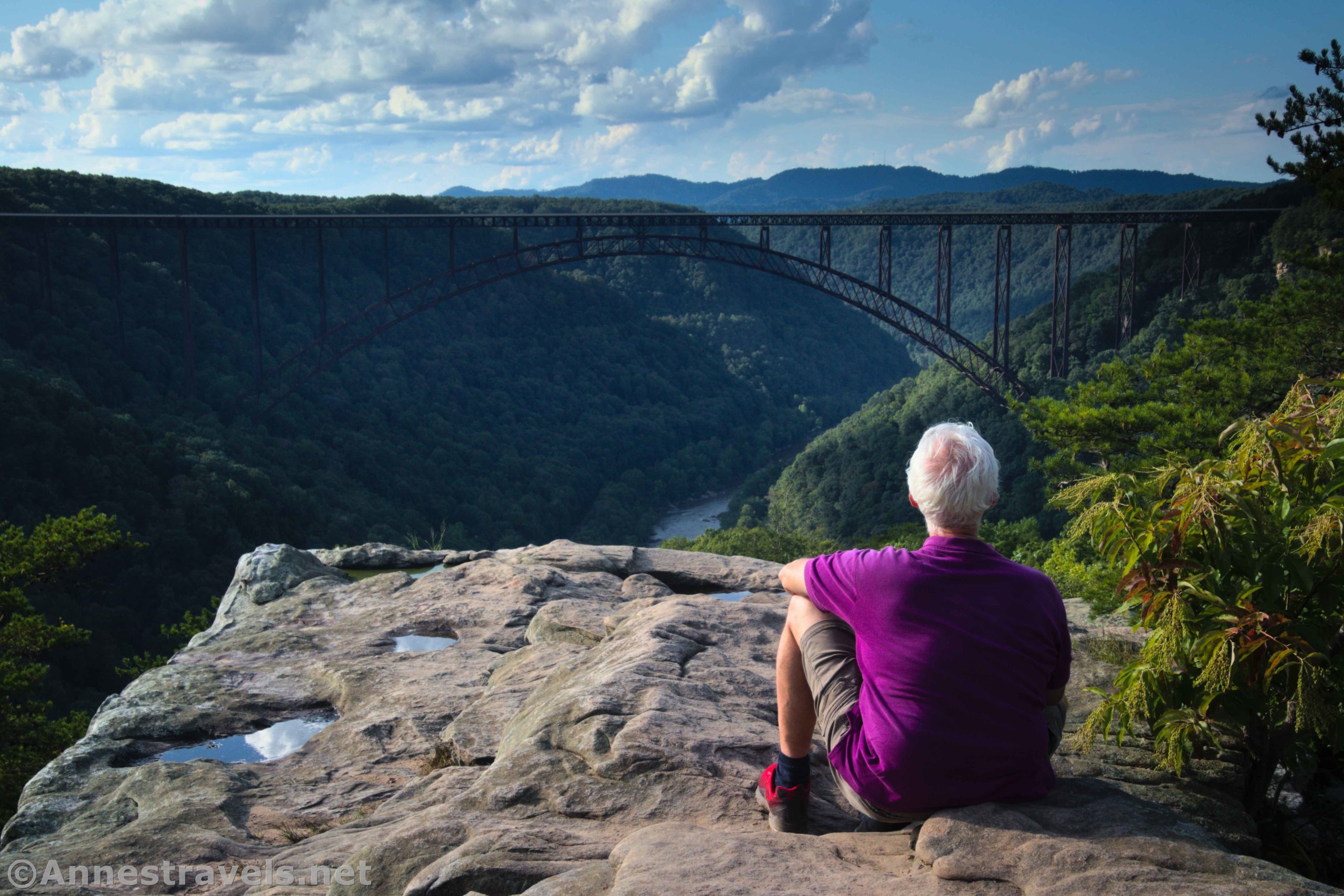
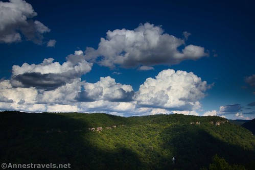
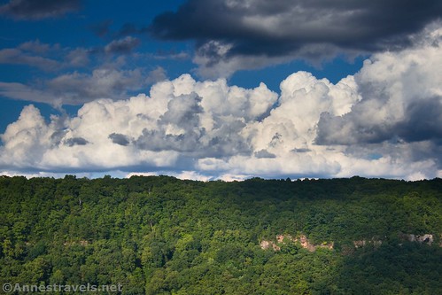
The point itself is a very large rock. From here, there are sweeping views down on New River Gorge, about 850ft. below, and to the New River Gorge Bridge, about 0.7 miles away as the crow flies.

The rain had left the depressions in the rock full of water. The potholes made for some nice reflections.

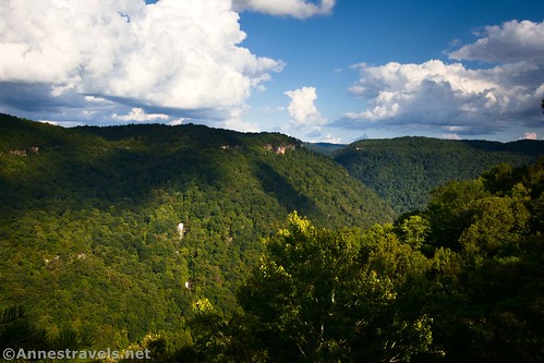
One of the things I loved about this viewpoint is that you can look both south and north up and down the gorge. There are so many views here!
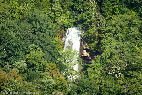
You can even see what appears to be an unnamed waterfall on Fern Creek crashing down the cliff into the gorge.
Enjoy the views, then retrace your steps back to the trailhead. The entire hike is only a little over 3 miles RT, so it’s well worth the trek if you happen to be in the area!

Round Trip Trail Length: 3.1 miles out & back
Elevation Gain: 543ft. (1,961ft. to 1,686ft.)
Facilities: Primitive restroom at trailhead; bicycle rack at the end of the bike-friendly trail
Fees: None

Trail Notes: Long Point doesn’t have railings. Use care by the sheer cliff edges. There are a few unofficial overlooks along the trail to Long Point; however, the real point is by far the best vantage point. Note that mountain bikes are permitted on the trail up to the point where the sign prohibits bicycles.

Trail 
![]()
Road ![]()
Signs ![]()
Scenery
Would I go 100 miles out of my way for this? ![]()
Overall Rating: ![]()
GPS Coordinates for Long Point
Trailhead: 38.0417990°, -081.0780940° (38°02.50794′, -081°04.68564′ / 38°02’30.4764″, -081°04’41.1384″) (1,959ft.) (0.0)
Marsh viewpoint: 338.0438080°, -081.0767100° (38°02.62848′, -081°04.60260′ / 38°02’37.7088″, -081°04’36.1560″) (1,954ft.) (0.18)
Fayetteville Trail Junction: 38.0465400°, -081.0750110° (38°02.79240′, -081°04.50066′ / 38°02’47.5440″, -081°04’30.0396″) (1,929ft.) (0.41)
Butcher Branch Trail: 38.0495910°, -081.0757670° (38°02.97546′, -081°04.54602′ / 38°02’58.5276″, -081°04’32.7612″) (1,885ft.) (0.68)
No Bikes sign: 38.0561490°, -081.0758470° (38°03.36894′, -081°04.55082′ / 38°03’22.1364″, -081°04’33.0492″) (1,867ft.) (1.29)
Long Point: 38.0596370°, -081.0773920° (38°03.57822′, -081°04.64352′ / 38°03’34.6932″, -081°04’38.6112″) (1,685ft.) (1.59)
End: 38.0417830°, -081.0781150° (38°02.50698′, -081°04.68690′ / 38°02’30.4188″, -081°04’41.2140″) (1,959ft.) (3.15)
The gpx file for Longs Point can be downloaded – please note that this and the GPS Coordinates are for reference only and should not be used as a sole resource when hiking this trail.
Download GPX File size: 45.6 KB Downloaded 381 times
(Note: I do my best to ensure that all downloads, the webpage, etc. are virus-free and accurate; however, I cannot be held responsible for any damage that might result, including but not limited to loss of data, damages to hardware, harm to users, from use of files, information, etc. from this website. Thanks!)
Getting to the Long Point Trailhead
From the New River Gorge Visitor Center, turn left to travel back out to US-19. Turn left to cross over the New River Gorge Bridge. Exactly 2 miles after turning onto US-19, turn left onto N Court Street (Route 16) toward Fayetteville. Drive 0.7 miles through Fayetteville, then take a slight left onto Gatewood Road for 1.8 miles (A brown sign indicates that Cunard and New River Gorge are down this road). Turn left onto Newton Road; the parking area will be on your left about a tenth of a mile later.

This Week’s Featured Product!
See the beauty of western West Virginia with this guide to New River Gorge National Park! The newly-updated book contains 20 trails to choose from, covering New River Gorge from north to south. Buy your copy here!