
Hiking the Ute Trail West
I think I’ve hiked the Ute Trail just about every time I’ve gone to Rocky Mountain National Park. There’s something top-of-the world about hiking the eastern section of the trail with views of the Continental Divide. However, on our last visit, we decided to do the Ute Trail West, a section of the trail we’d never hiked before. I’d say the views aren’t quite a stunning as the Ute Trail East (which is the Ute Trail most visitors are familiar with), but the first 2 miles (3.2 km) of the Ute Trail West are still quite pretty with a different vantage point than many other trails in the park – sort of like hiking the Trail Ridge Road just west of the Alpine Visitor Center, but better since you don’t have to watch where you’re driving!
Quick Stats
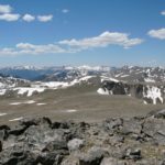
At the top of the trail
We started out one very cloudy day in August. We were used to clouds rolling in around noon, but on that day the clouds were rolling in right around sunrise. Since we were already at the Alpine Visitor Center to walk another trail (up the Alpine Ridge Trail to an unnamed peak where we’d taken a “historic” picture atop over 15 years earlier – and we wanted to take another for posterity’s sake J), and the weather didn’t look like it was getting any better, we decided to take a trail right there instead of wasting effort to get to another hiking area. The Ute Trail West begins right across the road from the visitor center parking area, so we packed up our gear, crossed the road, and began the walk down the trail simply marked, “Milner Pass, 4.2 miles. No Bicycles, No Pets”.
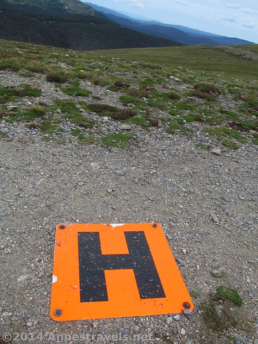
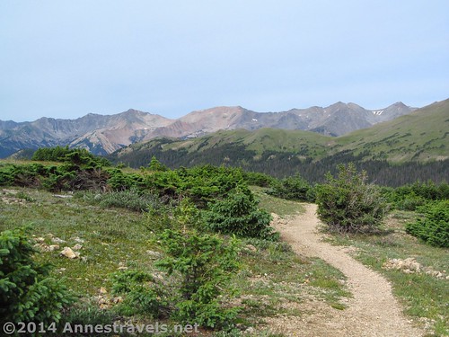
The helicopter pad in the middle of the trail
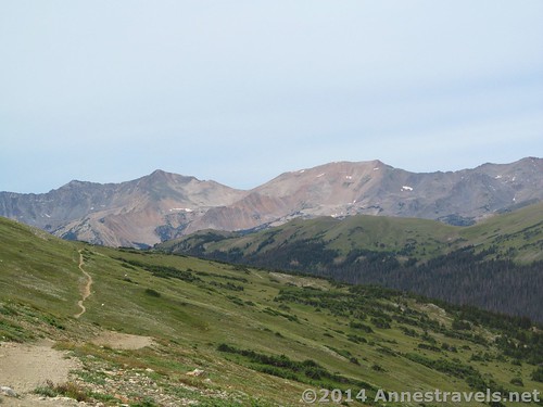
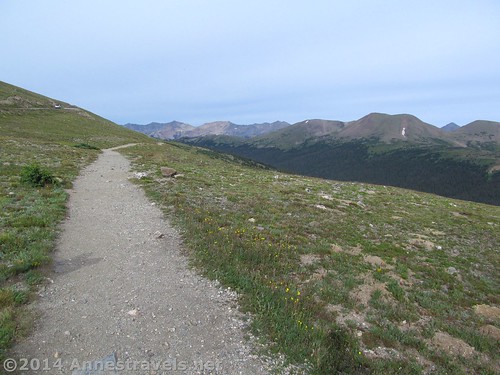
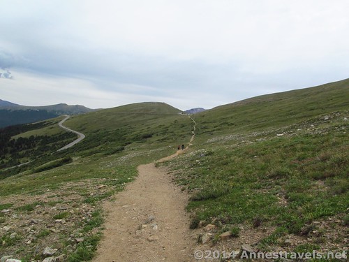
From the first, the trail descends, though not very quickly. Since it’s also fairly wide and gravely in this section, it’s basically a nice stroll through the tundra. (While you’re hiking, note the helicopter pad on the trail!) My only complaint about this section is that the Trail Ridge Road is very visible (but that didn’t spoil my day too much!) Specimen Mountain rises its great bulk nearby, but the peaks of the Never Summer Range are quite visible – this would be beautiful in early summer in the sunshine!
After descending for about a mile (1.6 km), the trail followed the contour of the land to turn left along the hillside we’d been hiking along for the entire trail thus far. Views opened up here even more of the Never Summer Range, even though there were beginning to be scrubby bushes along the trail. Here the trail also began to be narrower, though it was still obviously well-used. Views of the Continental Divide peaks (such as Mount Ida) and other nearby peaks (like the triangle-shaped Mount Julian) began to open up in this next section as the trail continued its gentle descent. After hiking 1.4 miles (2.25 km) we came to a set of small ponds. I don’t know if there are fish in the ponds, but they’re a pretty little diversion from the mountain peaks.
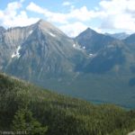
The Cache la Paudre River Valley
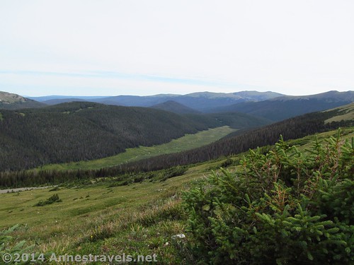
Only 0.1 mile (0.1 km) later, we entered Forest Canyon Pass. This is the height of the views toward the left down Forest Canyon; the views of the Mummy Range are also nice. Again, this would have been very, very nice in early summer in the sunshine, but on a cloudy day in August, it was simply a nice place.
The trail continues from here another 2.6 miles (4.2 km) to Milner Pass on the Trail Ridge Road – so if you have a shuttle vehicle you can leave a vehicle at Milner Pass, park at the Alpine Visitor Center, and then have an all-downhill trail. However, if you’re in this for the views (like we were) and don’t really want to hike 8.2 miles (13.2 km), Forest Canyon Pass makes a very good turning around place for a 3 mile (4.8 km) trek. We didn’t know that, so we continued another 0.5 miles (0.8 km) on an increasingly steep trail. At that point, the scrubby pines were becoming taller and beginning to obscure the view (which was now of the Never Summer Range), so we hiked 4 miles (6.4 km) overall on the Ute Trail West.
Entering the low bushes that mark the beginning of the tree line – we’re still well above Forest Canyon Pass, so the views will remain quite good for a bit yet.
After turning around, all we had left was the long uphill climb back up to the Alpine Visitor Center. Still, the grade wasn’t too bad, and it was only 2 miles (3.2 km), so it wasn’t a difficult hike.
When we returned, the parking area, which had been empty except for our van and maybe a couple other vehicles when we left, was overflowing with vehicles – and more were coming in! Wow! I’d forgotten just how busy the Trail Ridge Road can be in the summer – especially since seen less than 2 dozen people on the Ute Trail West!
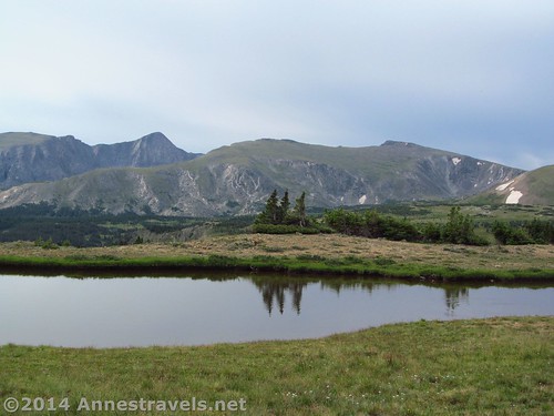
One of the small ponds above Forest Canyon Pass
Round Trip Trail Length: 4 miles (6.4 km) to the tree line and back; 3 miles (4.8 km) to Forest Canyon Pass and back; 8.2 miles (13.2 km) to Milner Pass and back
Starting Elevation: 11,795 ft. (3,595 m)
Ending Elevation: Forest Canyon Pass: 11,522 ft. (3,511 m); tree line: 11,390 ft. (3,471 m)
Net Elevation Change: To Forest Canyon Pass: 275 ft. (84 m); to the tree line: 407 ft. (124 m)
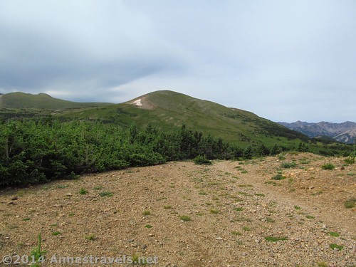
Forest Canyon Pass – the view is much better than this picture would indicate, though the views are actually better on either side of the pass than in it.
Facilities: Restrooms (real and primitive), gift shop, snack shop, visitor services, etc. at the Alpine Visitor Center
Fees: $20 per vehicle to enter Rocky Mountain National Park. America the Beautiful (Interagency), Senior (Golden Age), Access (Golden Access), Volunteer, Military, and Rocky Mountain Annual Passes also accepted
Trail 
![]()
![]()
Road
Signs ![]()
Scenery
Would I go 100 miles out of my way for this? ![]()
Overall Rating: ![]()
Key GPS Coordinates for the Ute Trail West:
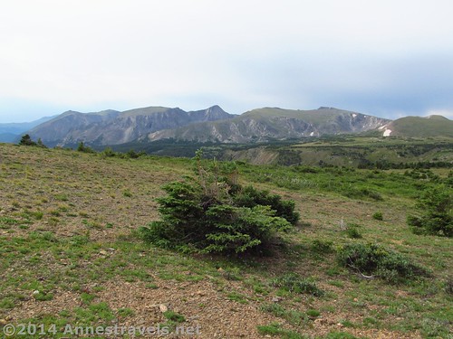
Looking across Forest Canyon toward Stones Peak, Terra Tomah Mountain, Mount Julian, and Mount Ida, among others.
Ute Trail West Parking Area (Alpine Visitor Center): 40.441357N / -105.754829W (40° 26’ 28.8852” / -105° 45’ 17.3844”)
Beginning of Ute Trail West: 40.44094N / -105.75575W (40° 26’ 27.3834” / -105° 45’ 20.7000”) (11,795 ft.; 3,595 m)
Helicopter Pad: 40.44077N / -105.75613W (40° 26’ 26.7720” / -105° 45’ 22.0674”) (11,779 ft.; 3,590 m)
First Pond: 40.43203N / -105.78111W (40° 25’ 55.3074” / -105° 46’ 51.9954”) (11,545 ft.; 3,518 m)
Forest Canyon Pass: 40.43025N / -105.78250W (40° 25’ 48.9000” / -105° 46’ 56.9994”) (11,522 ft.; 3,512 m)
Tree Line: 40.42951N / -105.78862W (40° 25’ 46.2360” / -105° 47’ 19.0314”) (11,390 ft.; 3,471 m)
The gpx file for the Ute Trail West can be downloaded – please note that this and the GPS Coordinates are for reference only and should not be used as a sole resource when hiking this trail.
Download GPX File size: 65.0 KB Downloaded 427 times
(Note: I do my best to ensure that all downloads, the webpage, etc. are virus-free and accurate; however, I cannot be held responsible for any damage that might result, including but not limited to loss of data, damages to hardware, harm to users, from use of files, information, etc. from this website. Thanks!)
Getting to the Ute Trail West:
Hiking back up toward the Alpine Visitor Center
From the Beaver Meadows Entrance Station (east side of Rocky Mountain National Park), drive 20.1 miles (32.3 km) up the Trail Ridge Road to the Alpine Visitor Center, on right. Find a parking space (can be difficult in the summer months – but one usually opens up (and is filled again) quickly); the Ute Trail West begins across the Trail Ridge Road from the Alpine Visitor Center parking area.
Alternatively, from the Grand Lake Entrance Station (west side of Rocky Mountain National Park), drive 20.2 miles (32.5 km) on the Trail Ridge Road to the Alpine Visitor Center, on left. Note that the parking area is fairly small, and therefore fills up quickly during the summer months, but vehicles come and go quickly, so if you wait, you may be able to get a parking space fairly quickly. The Ute Trail West begins across the Trail Ridge Road from the parking area.
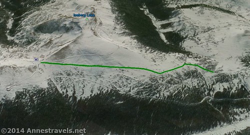
Visual map of the Ute Trail West from the Alpine Visitor Center (left) 2 miles down the trail to the treeline (right).
Zoom map out to browse nearby hikes & places of interest
This Week’s Featured Product!
More dayhikes in Rocky Mountain National Park can be found in this popular guide to the park. From waterfalls to 14ers, this book offers a variety of hiking options to both experienced and novice hikers.
More Related Posts:
 Fishermen, Short Hike, & Views: Lake Agnes
 Hidden Lake Lookout: A Most Fabulous View!
 The Beautiful Water & Wildflowers of Cracker Lake
 Walk in the Footsteps of Indians on the Ute Trail
 Awesome Views in Rocky Mountain from Flattop Mountain and Hallett Peak
 Good Views and a Fire Lookout, Too at Numa Lookout
Pingback: Anne's Travels » The Alpine Ridge Trail: Topping Huffers Hill!
Pingback: Holzwarth Historic Site - Worth a Summer Stop!