
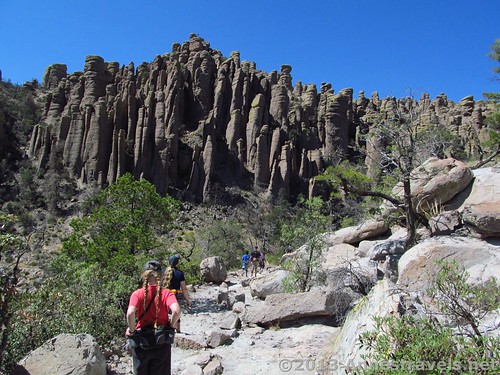
Hiking on the early part of the Echo Canyon Trail
By the time we’d reached the Echo Canyon Trail (after hiking the Ed Riggs Trail, Mushroom Rock Trail, and Big Balancing Rock Trail, taking a side-loop to hike around the Heart of Rocks Trail, and then traversing the Sarah Deming Trail and Upper Rhyolite Trail) we were ready to be back at our vehicle. The hike up from the bottom of Rhyolite Canyon to its rim isn’t exactly a stroll in the park! Also, we’d hiked this trail several years earlier and hadn’t found it to be very spectacular. So, we were in for a very nice surprise to discover just how nice the Echo Canyon Trail is, especially at only 1.6 miles long (2.5 km). However, I suspect some of the niceness came from the fact that the fire came through this section so you can actually see – really see – the formations that used to be hidden by trees. (I suspect the trail was made after the area had been logged – an opinion, but it would make sense why they chose the trails they did since the views are now pretty awesome!) So, you might want to hike this trail soon before the trees grow up again! That said, there really aren’t that many burned trees, so they don’t detract from the view.
Quick Stats
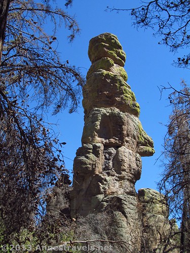
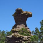
The “Monkey Face” in Echo Park
The trail, beginning at the Upper Rhyolite Trail / Hailstone Trail junction, hugs the edge of Rhyolite Canyon for a short ways, then turns away from the canyon up a side canyon. Some formations appear in this area, looking a bit like tall fins. The further you go up the side canyon, the more formations there seem to be in this area. The trail begins to climb again, crossing a seasonal stream before entering Echo Park. This is the worst place for the burned trees, but the lack of leaves also allows you to see the really cool formations that surround the Park. One of my favorites looked something like the head of a monkey. The echos are pretty good here, too…so it’s no wonder about the Park’s name. 🙂
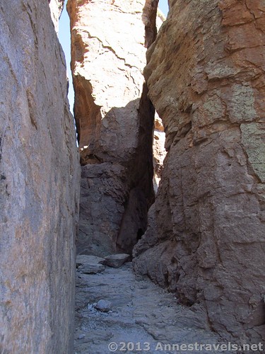
In Wall Street
Continuing up the trail from Echo Park, the trail climbs up into Wall Street (this is not marked with a sign). Wall Street is fun because you get to walk through the middle of some very high and impressive spires, with the walls rising steeply on both sides. A few holes in the walls make for some nice views and great photo framing opportunities. Actually, the trail in this section is a switchback, and there’s a hole in the walls above where those on the higher trail can look down at those on the lower trail…fun!!! After leaving Wall Street, look back at it…it’s quite an impressive opening, especially with people hiking out of it. You’d never guess that a trail went right through those rocks.
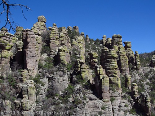
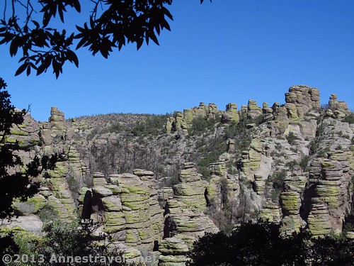
A peek-a-boo view of spires
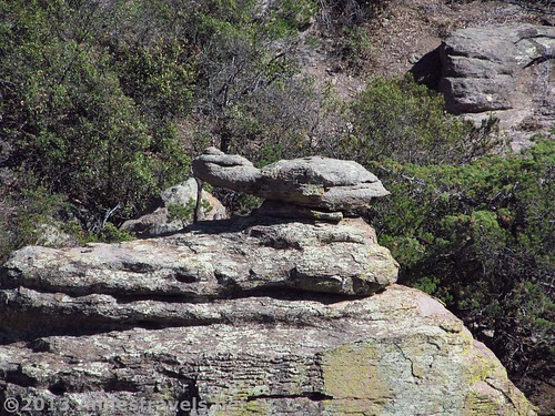
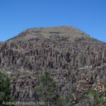
The section after Wall Street is where you begin to again see interestingly shaped rock formations. As the trail climbs higher (and closer to your vehicle), the tops of more spires come into view, some of them quite fun to look at. Many are balancing rocks of one sort or another, while others simply look like stacks of blocks. There are also peek-a-boo views into the canyon full of spires, and even across the valley toward the Heart of Rocks area. My favorite rock looked something like a turtle, lifting its head to look at something outside its shell.
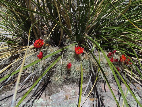
Cactus blooms along the trail
The Echo Canyon Trail will take you right back to the Echo Canyon Parking Area (turning left at the sign for the Echo Canyon Trail) where we’d left our vehicle. If you parked in the Massai Point Parking Area, turn right at the Echo Canyon Trail sign, follow the Massai Point Trail for 0.2 mile (0.3 km), then turn left up the Massai Point Trail for another 0.3 miles (0.4 km) to Massai Point.
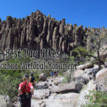
The entire Chiricahua Loop is spectacular, and the Echo Canyon Trail is certainly no let down after the rest of the hike…in fact…if you can’t do the entire loop, the Echo Canyon Trail is the next best thing.
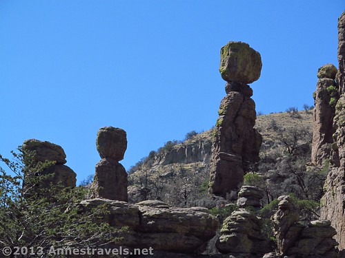
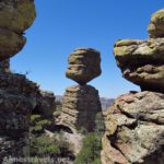
Balancing Rocks
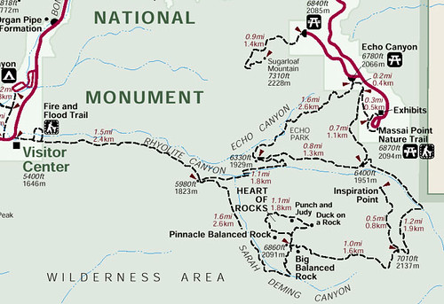
Round Trip Trail Length: The Echo Canyon Trail, RT, is 3.2 miles (5.1 km); following the Echo Canyon Trail, Hailstone Trail, and Ed Riggs Trail as a loop is 3.3 miles (5.3 km). RT loop (including the Heart of Rocks Trail) is 8.5 miles (13.6 km) (though my GPS came out saying 8.7 miles (14 km)) – a map of the trail system is at the end of this post.
Highest Elevation (on loop): 7,480 ft. (2,280 m) (Echo Canyon Parking Area)
Lowest Elevation (on loop): 5,900 ft. (1,798 m) (Sarah Deming Trail / Rhyolite Trail Junction)
Net Elevation Gain/Loss: 1,680 ft. (512 m)
Facilities: Primitive restrooms at the Echo Canyon Trailhead – otherwise, none.
Fees: $5 per person fee (age 16 and older) to enter Chiricahua National Monument, valid 7 days. America the Beautiful (Interagency), Senior (Golden Age), Access (Golden Access), Volunteer, Military, and Chiricahua Annual Passes also accepted – however, note that these only cover the pass holder and three other individuals (we ended up having to pay for one extra person; unlike some parks, these staff members seem serious about enforcing this (but they were very nice, all the same!)). Update: The entrance fees to Chiricahua have been eliminated, so you can now visit for free!
Trail 
Road
Signs
Scenery
Would I go 100 miles out of my way for this?
Overall Rating:
Key GPS Coordinates for the trail to the Big Balanced Rock
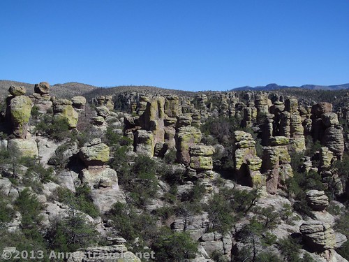
Another peek-a-boo view
Echo Canyon Trail Junction: 32.00369N / -109.32664W (32° 0′ 13.2834″ / -109° 19′ 35.9034″) (6,282 ft.; 1,914 m)
Wall Street: 32.00694N / -109.32302W (32° 0′ 24.984″ / -109° 19′ 22.8714″) (6,415 ft.; 1,955 m)
Turtle: 32.00935N / -109.31821W (32° 0′ 33.6594″ / -109° 19′ 5.5554″) (6,732 ft.; 2,052 m)
The gpx file for the Chiricahua Heart of Rocks Loop can be downloaded – please note that this and the GPS Coordinates are for reference only and should not be used as a sole resource when hiking this trail.
Download GPS File File size: 208.5 KB Downloaded 342 times
(Note: I do my best to ensure that all downloads, the webpage, etc. are virus-free and accurate; however, I cannot be held responsible for any damage that might result, including but not limited to loss of data, damages to hardware, harm to users, from use of files, information, etc. from this website. Thanks!)
Getting to the Echo Canyon Parking Area
Spire views
From I-10 in Arizona, take Exit 340 in Willcox. Head southeast (left if you’re coming from the east, right if you’re coming from the west) on Fort Grant Road/W Rex Allen Drive for 1.1 miles (1.7 km). Turn right onto AZ-186 E (signs will point toward Interstate 10 Business). After 0.7 miles (1.1 km), turn left to continue on AZ-186 E; drive 31.4 miles (50.5 km). Turn left onto AZ-181 for 3 miles (4.8 km), then continue on E Bonita Canyon Road for 7.3 miles (11.7 km). Turn right, following the signs for Sugarloaf and Echo Canyon; take an almost immediate left into the Echo Canyon Parking Area.
The turtle
If you’re coming from the visitor center, turn left out of the parking area and drive 5.3 miles (8.5 km) to the turnoff for Sugarloaf. Turn right here, then take an almost immediately left into the Echo Canyon Parking Area.
Trail map of the Heart of Rocks area, including the Sarah Deming Trail and Upper Rhyolite Trail
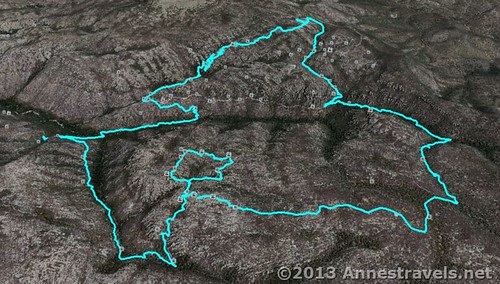
Visual map of the Heart of Rocks Loop – Echo Canyon Parking Area to the Ed Riggs Trail, up the Mushroom Rock Trail, across on the Big Balanced Rock Trail, around the Heart of Rocks Loop, down the Sarah Deming Trail, back up the Upper Rhyolite Trail, then back to the Echo Canyon Parking Area via the Echo Canyon Trail.
This Week’s Featured Product!
Want more trail information about Chiricahua and the surrounding area? This guide describes 100 hikes in the southern third of Arizona, including Chiricahua National Monument.


Hi,my wife and me are planning a trip in Colorado-New Mexico-Texas-Arizona-Utah,so we will visite also the Chiricaua N.M. Would you like send us more information on Echo Canyon Trail and other intresting trails? We’ll stay there on July.
I’m sorry on my no so good English. However thank you very much.
Mary and Enzo Bonacina.
Mary and Enzo,
That sounds like a very fun trip! Other good trails that form a loop with the Echo Canyon Trail are the Ed Riggs Trail / Mushroom Rock Trail (https://www.annestravels.net/chiricahua-loop-big-balanced-rock/), the Heat of Rocks Trail (this is my favoreite trail in Chiricahua) (https://www.annestravels.net/heart-of-rocks/), and the Sarah Deming / Upper Rhyolite Trail (https://www.annestravels.net/chiricahua-sarah-deming-trail-upper-rhyolite-trails/). If you like history, Faraway Ranch is a short, interesting trail (https://www.annestravels.net/faraway-ranch-chiricahua/).
Hope that helps…Chiricahua is a fascinating place to visit!
Anne
Just an update… There’s no longer an entrance fee at Chiricahua NM.
I’m not surprised you were glad to get back to your car… You saved the steepest part of your climb for last! The hike out is a little more gradual if you do it in the reverse direction; in other words, start the hike by going down the Echo Canyon Trail and hike out the Riggs. Still a long day however you do it.
Great photos. Thanks for sharing.
Hi Dick, Yes I did actually know that the fee had been waived, but (silly me) I didn’t think to come here and update the page! Thanks for the update!
Pingback: Taste and See that the Lord is Good - Anne's Travels