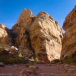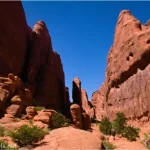
Possibly my favorite adventure in western Virginia last fall was The Great Channels, located north of Abingdon. The hike was steep, forested, and fairly uninteresting, but the top boasted great views before dropping you into a labyrinth of slot canyons – East Coast-style slots, but slot canyons all the same! It was so much fun to explore all the nooks and crannies, and it’s big enough that it took me about 40 minutes to see all of the canyons. I’d go back in a heartbeat!
Quick Stats
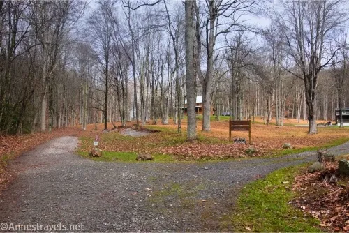
The biggest barrier to visiting The Great Channels is parking. Only 10 spots are available, and when they’re full, that’s it. No parking is allowed along the road (at least, nowhere nearby), nor is double-parking. I figured a Wednesday morning in November after a heavy rain wouldn’t be too terribly popular, and I was right. There were two cars when I arrived, and another two cars in the lot when I left.
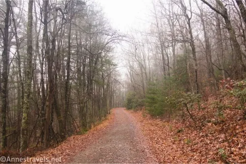
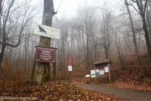
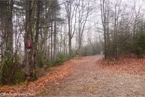
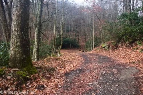
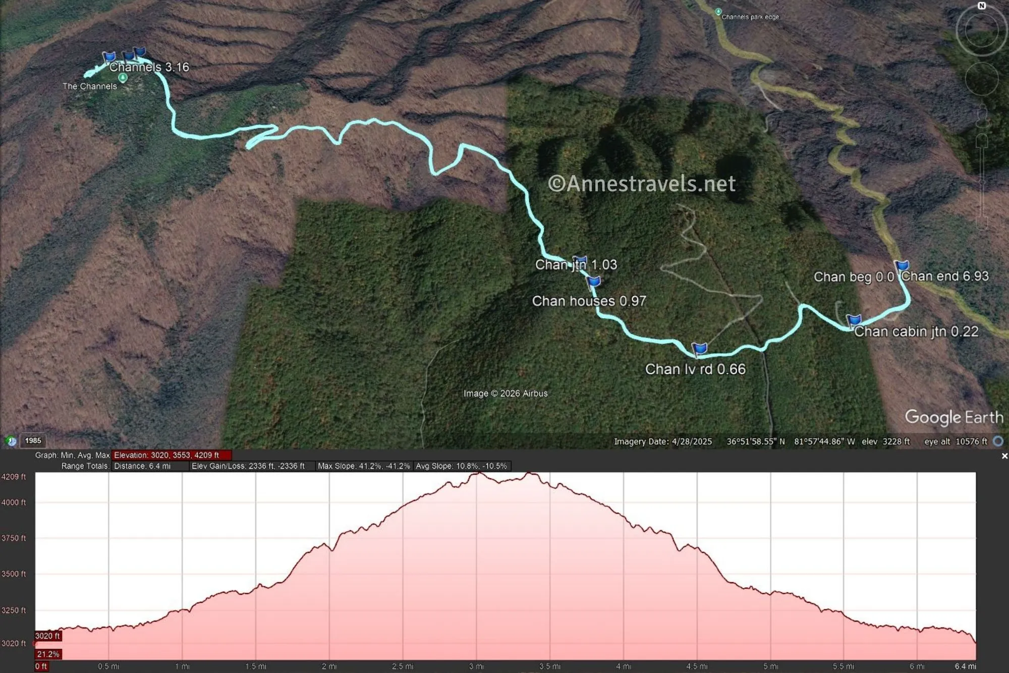
0.0 The Great Channels Trailhead (3,014ft.). Head up the gravel road past the trail kiosk, then walk around the gate and continue up the road. The road is usually a bit steep but not too bad, and the tread is firm. Pass a driveway on the right at 0.2 miles. (36.8645780°, -081.9469890°)
0.7 Road split (3,109ft.). Take the left fork to continue uphill. After 0.3 miles, you’ll enter a small cluster of cabins. Please respect the privacy of the owners. In this area, the trail will turn left to leave the road. (36.8611910°, -081.9556280°)
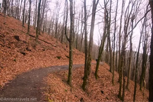
1.0 Turn left (3,215ft.). Turn left to leave the gravel road you’ve been following. Pass another sign kiosk and continue walking uphill following an old road or ATV track (closed for many years from the looks of things). Keep hiking uphill. There are occasional peek-a-boo views through the trees to the surrounding mountains. The day I hiked was very foggy, so we didn’t get much in the way of views, but I could just barely see that they were out there when I was coming back down. (36.8642070°, -081.9596450°)
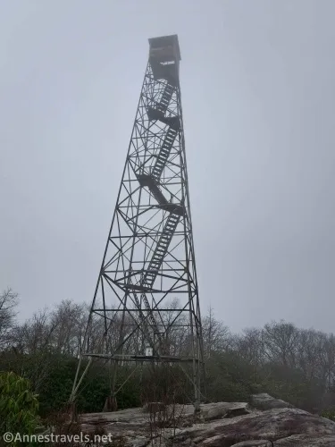
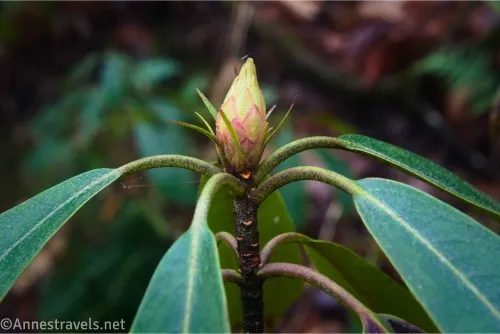
2.9 Turn left onto the Spur Trail(4,126ft.). I’m not sure exactly where the right trail goes, but I believe it’s down to another trailhead many miles away. The left fork climbs through rhododendron bushes. Ignore a side-trail on the left at the end of a switchback. At last, you’ll pop out of the forest near an old fire tower. (36.8719360°, -081.9783120°)
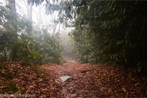
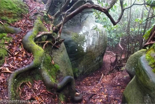
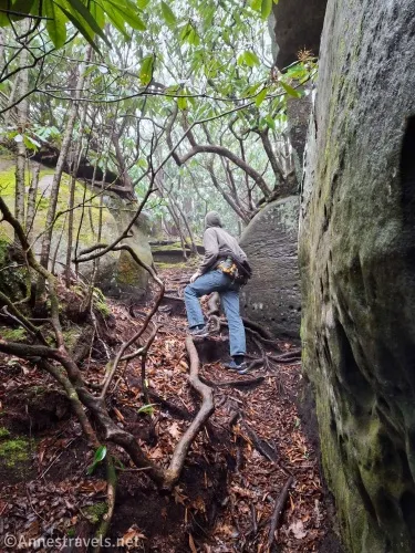
3.1 Fire Tower (4,193ft.). I expect there are some good views from the rocks near here; it was so foggy that I didn’t try very hard to see very much! The fire tower, itself, is closed to the public – they’ve tried to block it off, etc., and put up signs. To continue to The Great Channels, walk straight beneath the fire tower and follow the white blazes through the woods. The path will eventually split – the left fork goes up onto a rock where you can look down on the Channels from above, while the right fork becomes almost social-trail-looking as it drops steeply between the rhododendrons down into The Great Channels. (36.8713080°, -081.9784610°)
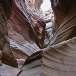
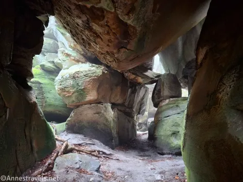
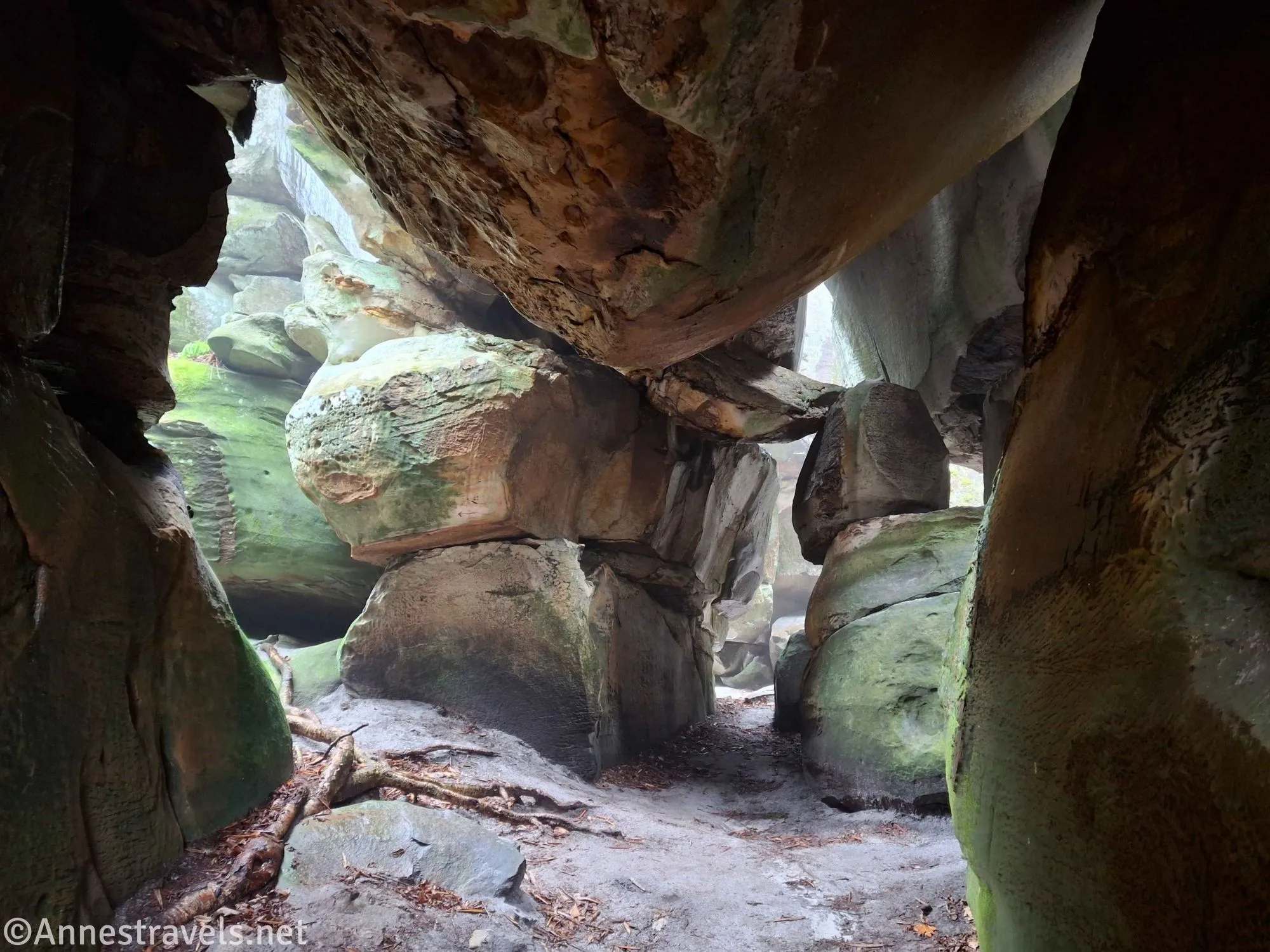
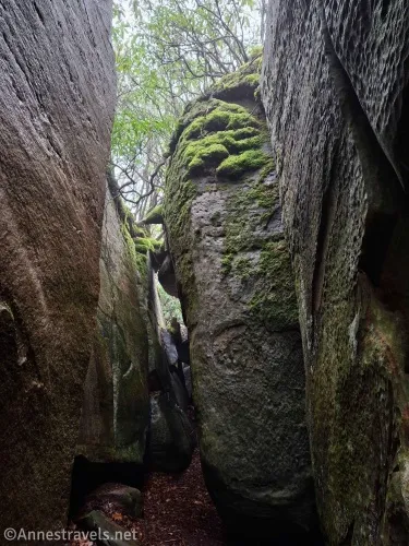
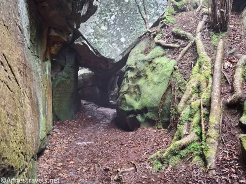
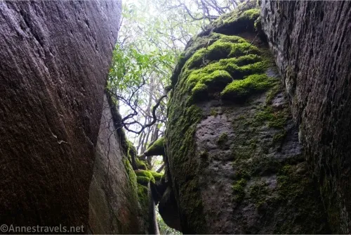
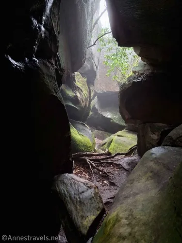
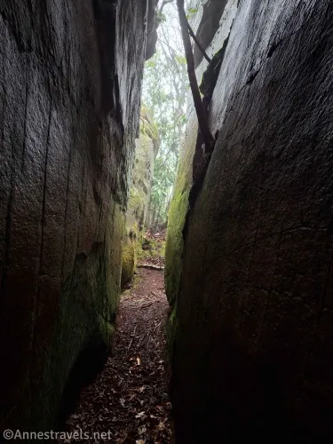
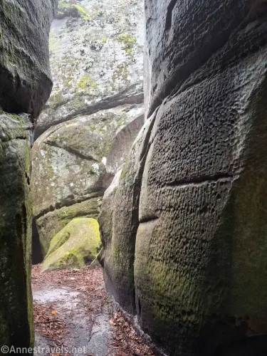
3.1 The Great Channels (4,171ft.). This is where the fun really begins. There are many slot canyons between the huge rocks, some rock formations and arches, and a few caves, and just so many places to explore! Multiple times, I’d find I’d gone in a circle while trying to explore new places. It’s just so much fun! There is some graffiti and a few places where people have had fires (just don’t), but in general, it was clean and I felt perfectly safe exploring on my own. (Well, there was that one dark area that smelled like animals; I didn’t hang out there too long… and then as I was exiting, my companion lay in wait in a side-canyon and whispered, “Me Precious!!” right as I went by… I won’t say I didn’t scream. Lol). When you’ve finished exploring, retrace your steps back to the fire tower and down the mountain to your vehicle. (36.8712830°, -081.9792650°)
Round Trip Trail Distance: 6.9 miles
Elevation Gain: 2,336ft. (3,020ft. to 4,209ft.)
Facilities: None
Fees: None
Trail Notes: I already talked about parking; be ready to go somewhere else if the parking lot is full. There is very little cell signal (at least on Verizon) here, though I got a little up near the fire tower. The trail up is always easy to follow. I thought the trail was steep, but friends who have done it (thanks for the trail suggestion, M!) declare it not too bad by Maine standards. One of the good things about the limited parking is that there are few people at a time trying to explore the slot canyons – most are too narrow to pass each other comfortably.
Trail 
![]()
![]()
Road ![]()
Signs ![]()
Scenery ![]()
Would I go 100 miles out of my way for this?
Overall Rating: ![]()
GPS Coordinates for the Great Channels
TH: 36.8645780°, -081.9469890° (36°51.87468′, -081°56.81934′ / 36°51’52.4808″, -081°56’49.1604″) (3,014ft.) (0.0)
Cabin junction: 36.8622080°, -081.9498000° (36°51.73248′, -081°56.98800’/ 36°51’43.9488″, -081°56’59.2800″) (3,085ft.) (0.22)
Leave road: 36.8611910°, -081.9556280° (36°51.67146′, -081°57.33768′ / 36°51’40.2876″, -081°57’20.2608″) (3,109ft.) (0.66)
Houses: 36.8634320°, -081.9592100° (36°51.80592′, -081°57.55260′ / 36°51’48.3552″, -081°57’33.1560″) (3,205ft.) (0.97)
Junction: 36.8642070°, -081.9596450° (36°51.85242′, -081°57.57870′ / 36°51’51.1452″, -081°57’34.7220″) (3,215ft.) (1.03)
Spur trail junction: 36.8719360°, -081.9783120° (36°52.31616′, -081°58.69872′ / 36°52’18.9696″, -081°58’41.9232″) (4,126ft.) (2.96)
Fire Tower: 36.8713080°, -081.9784610° (36°52.27848′, -081°58.70766′ / 36°52’16.7088″, -081°58’42.4596″) (4,193ft.) (3.10)
Channels: 36.8712830°, -081.9792650° (36°52.27698′, -081°58.75590′ / 36°52’16.6188″, -081°58’45.3540″) (4,171ft.) (3.16)
End: 36.8645770°, -081.9470320° (36°51.87462′, -081°56.82192′ / 36°51’52.4772″, -081°56’49.3152″) (3,015ft.) (6.93)
The gpx file for the Great Channels can be downloaded – please note that this and the GPS Coordinates are for reference only and should not be used as a sole resource when hiking this trail.
Download GPX File size: 149.3 KB Downloaded 181 times
(Note: I do my best to ensure that all downloads, the webpage, etc. are virus-free and accurate; however, I cannot be held responsible for any damage that might result, including but not limited to loss of data, damages to hardware, harm to users, from use of files, information, etc. from this website. Thanks!)
Getting to the Great Channels
From Abingdon, take I-81 East to Exit 24. At the bottom of the exit ramp, turn left onto VA-80W. After 0.3 miles, turn left onto Glenbrook Avenue to stay on VA-180. Turn left again onto VA-80 W 0.4 miles later. After 0.2 miles, turn right onto VA-80W (Lindell Road) for 4.8 miles. Turn left onto VA-80W for another 5.2 miles, then turn left to stay on VA-80W 3.7 miles as the road winds up to the top of the ridge. As the road crests the ridge and begins down the other side, the parking area will be on the left.
Explore Southern Virginia Hiking Trails
There’s a lot of great scenery (and trails!) to be found in southern Virginia, and this guide attempts to get you to a lot of them! Buy your copy here.