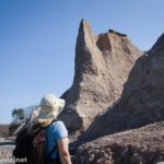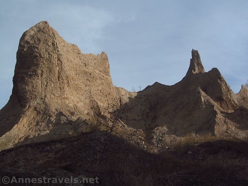
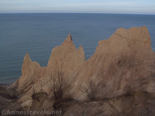
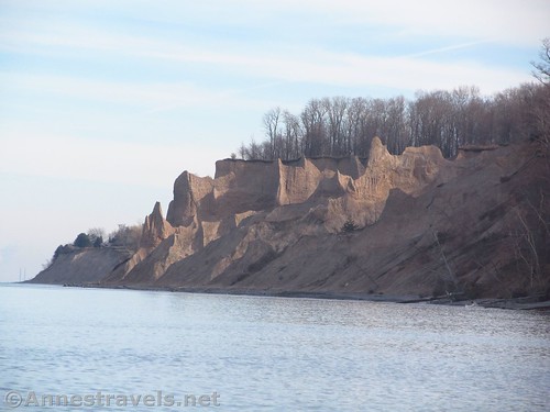
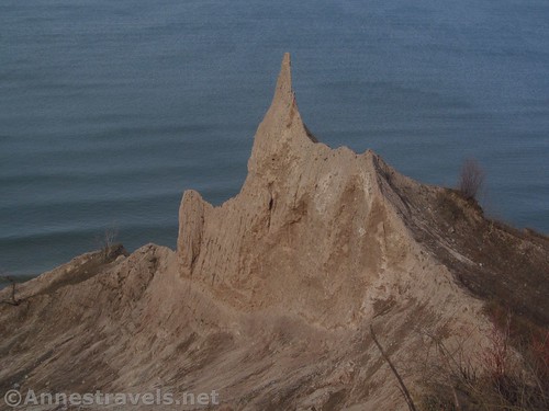
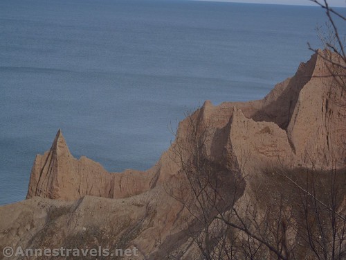
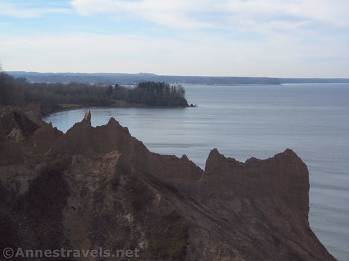
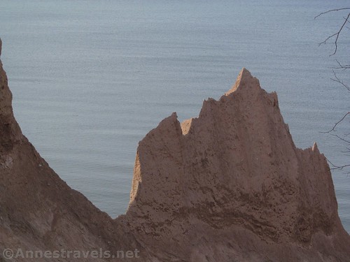
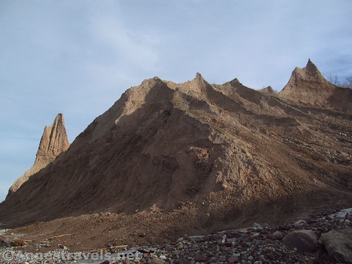
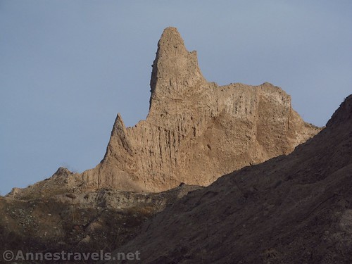
Chimney Bluffs has long been a hidden gem of western New York State. Located right on the shore of Lake Ontario, the park has seen an influx of visitors in recent years to see the incredible badland spires in the bluffs along the lake. I’ve never seen anything else like it along Lake Ontario, though it is a little reminiscent of a few of the formations at Pictured Rocks National Lakeshore (on Lake Superior).
Quick Stats
(Affiliate links are present on this page.)
I revisited Chimney Bluffs in mid-December. For whatever reason, despite visiting fairly frequently 20 years ago, I hadn’t been in close to 15 years, but I was very impressed with the spires and bluffs, as well as the views across Lake Ontario.
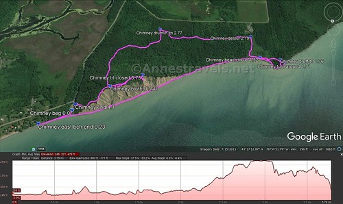
We started out from the less-official parking area (it’s still very official, but there aren’t any services except primitive restrooms, which were locked in mid-December). You can see where the road used to extend a bit further, but storms on the lake have been eroding what is left of the pavement. If you walk a bit to the right, a social trail takes you down to the beach without a scramble, which is required if you go down to the beach right at the end of the parking lot.
The sun was very low in the south this time of year – the sun will just plain be better in the summer, when the sun is further north and therefore shining across the lake – so we decided to hike west a bit along the beach to let the sun rise over the hills.
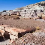
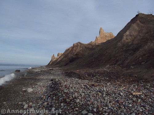
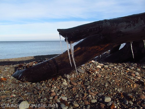
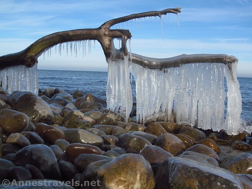
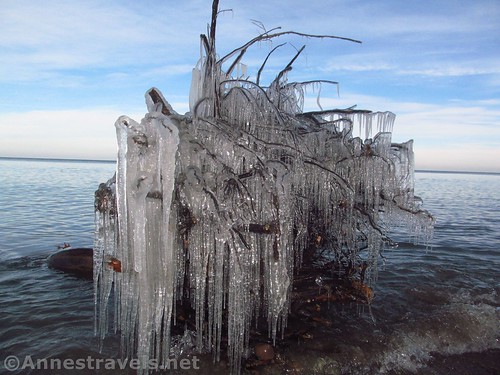
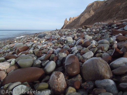
There were a lot of icicles on the trees washed up on the beach. It really hadn’t been that cold, but I guess the water was cold enough to freeze icicles overnight. The rocks on the beach were also frozen, which were sometimes beautiful and actually pretty stable to walk on as long as you don’t slip on the ice.
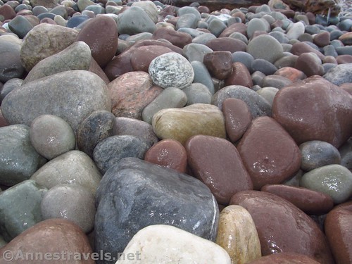
After 0.25 miles, we came across signs that told us the park ended and not to trespass any further. So we turned around. It was a very pleasant walk along the beach, and if you like lake stones, there are some nice ones.
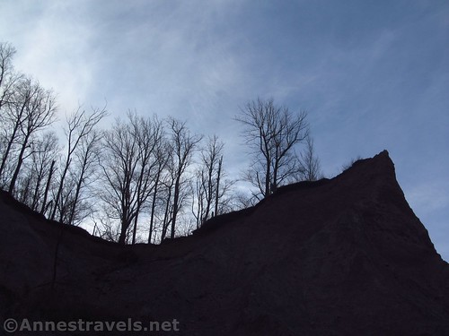
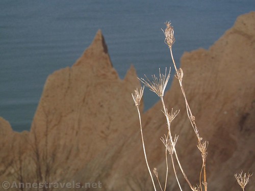
We wandered the beach eastward toward the formations. This “early” in the morning (it was after 10am!), the formations were still in shadow, so we took a few silhouette pictures and kept going. The best of the formations are within about a half mile of the parking area.
Since we were at the park to hike, we kept walking along the beach. It’s very nice, though there is a fair amount of deadfall / driftwood to scramble over in places. After a mile from the trailhead, a semi-official trail goes up to the picnic area and the more-official parking area. Since we’d never done it before, we kept walking around Garner Point.
The beach definitely becomes wilder after the point. However, shortly after rounding the point, a sign pointed toward the “clothing-optional beach”. We didn’t think we’d have much trouble this time of year – and it also happens to be the hunting-allowed area – but we still decided it was time to take one of the many social trails up into the forest.
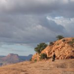
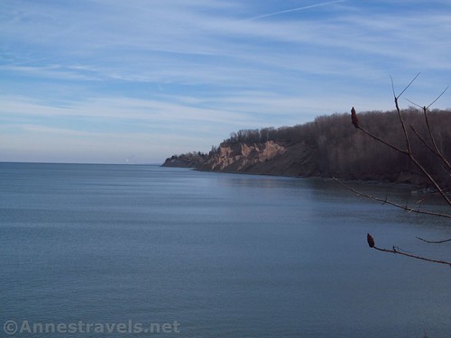
Turn left and uphill, and you’ll fairly quickly intersect a trail. Turn left a short distance up to the top of Garner Point. The views aren’t great, but they’re not bad, either. Looking out, we could see the rocks that were all that remained of the point when it had extended further out into Lake Ontario.
We walked back down the trail and took the first left (Bluff Trail) to descend down to the picnic area. We wanted to walk straight across the picnic area and take the Bluff Trail through the woods and then across the top of the bluffs, but the Bluff Trail is closed for the next year or so (should be open in late 2019 or 2020). So we walked up the road to take the West Trail and then turn left on the Drumlin Trail to take you through the forest to the Bluff Trail. It’s really a pretty pleasant trail system so I couldn’t complain too much.
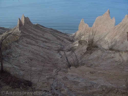
When we came to the Bluff Trail, we were very happy that it wasn’t closed. So we turned left so we could walk along the top of the bluff formations. There are usually two trails: the old one right along the brink of the edge (be careful of undercut edges!) and the second, new trail a bit further from the edge. There are plenty of social trails between the two.
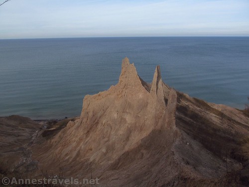
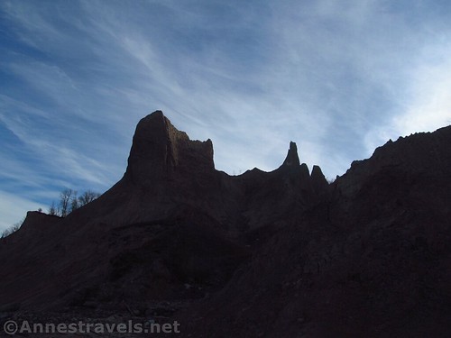
The great thing about the Bluff Trail is that you get quite a good view of the rock formations. Unlike 20 years ago, you can’t go and climb all over the formations (wise, I suppose, though I know a few kids who happily and safely scrambled all over the place and never got hurt).
We walked to nearly the end of the formations (about 0.3 miles from the Drumlin Trail), then the trail was closed for reconstruction. That didn’t stop the social trail from going straight by the orange tape, but we turned around and walked back along the Bluff Trail back to the parking area.
The last thing the trail does is to steeply (very steeply!) descend back to the parking area, ending up right behind the restrooms, about 0.4 miles from the closure.
Overall, we hiked 4.1 miles, and it was great fun, and very beautiful! In December we saw only a handful of other people, though I expect it’s fairly crowded on summer weekends. Whatever time of year you visit, the formations are always worth seeing, and the hiking is very pleasant!

Round Trip Length: Varies; I’d recommend at least 1.0 miles; we hiked 4.1 miles
Net Elevation Gain: 169ft. (246ft. on the lakeshore to 415ft. atop the cliffs)
Facilities: Restrooms in season; picnic area at the “official” parking area
Fees: $5/vehicle, collected April 1-October 31. I didn’t see a collection station at the “semi-official” parking area, but there probably is something there during the fee collection season.
Pets: Leashed on trails; no pets on the beach
Rules & Regs: Don’t climb on the bluffs; no Hunting, Fishing, etc. except where posted; no camping without permission; keep vehicles on the roads; park off the road or in parking lots; don’t trespass; if you start a fire, stay with it at all times and be sure it’s out when you leave; no littering; don’t remove, cut, or damage vegetation; swimming only in designated area (i.e., no swimming here); motorized boats only in designated areas; no mooring or storage of boats overnight; no grazing domestic animals; don’t do anything that puts others in danger; no damaging gates, fences, signs, buildings, etc.; obey the environmental conservation law. So really, it’s a lot of rules that you’d probably follow anyway.
Trail Notes: These really are unique for New York State. They’re also a favorite for photographers. Use extreme care near the cliff edges (no guardrails exist – which is good if you want to see the formations) and recognize that the lakestones on the beach make for some slightly insecure footing (wear good shoes or boots).
Trail 
![]()
![]()
Road ![]()
Signs ![]()
Scenery
Would I go 100 miles out of my way for this? ![]()
Overall Rating: ![]()
Key GPS Coordinates for Chimney Bluffs State Park
Trailhead: 43.2905333°, -076.9064500° (N43° 17.432′ W76° 54.387′ / 43°17’25.9200″, -076°54’23.2200″) (243 ft.) (0.0)
East end of beach: 43.2916833°, -076.9041167° (N43° 17.501′ W76° 54.247′ / 43°17’30.0600″, -076°54’14.8200″) (253ft.) (0.23)
Trail up to picnic area: 43.2843667°, -076.9229500° (N43° 17.062′ W76° 55.377′ / 43°17’03.7200″, -076°55’22.6200″) (246 ft.) (1.52)
Turn up into woods: 43.2847333°, -076.9253167° (N43° 17.084′ W76° 55.519′ / 43°17’05.0400″, -076°55’31.1400″) (250ft.) (1.71)
Bluff Trail on Garner Point: 43.2845500°, -076.9249000° (N43° 17.073′ W76° 55.494′ 43°17’04.3800″, -076°55’29.6400″) (293ft.) (1.76)
East-West Trail Junction: 43.2821167°, -076.9222667° (N43° 16.927′ W76° 55.336′ / 43°16’55.6200″, -076°55’20.1600″) (274ft.) (2.19)
East-West Trail / Drumlin Trail Junction: 43.2821500°, -076.9124500° (N43° 16.929′ W76° 54.747′ / 43°16’55.7400″, -076°54’44.8200″) (322ft.) (2.77)
Bluff Trail / Drumlin Trail Junction: 43.2886167°, -076.9091167° (N43° 17.317′ W76° 54.547′ / 43°17’19.0200″, -076°54’32.8200″) (415ft.) (3.41)
Bluff Trail east end closure: 43.2874000°, -076.9118000° (N43° 17.244′ W76° 54.708′ / 43°17’14.6400″, -076°54’42.4800″) (391ft.) (3.73)
Hike End (behind restrooms): 43.2900833°, -076.9065333° (N43° 17.405′ W76° 54.392′ / 43°17’24.3000″, -076°54’23.5200″) (268ft.) (4.1)
The gpx file for my trek around Chimney Bluffs State Park can be downloaded – please note that this and the GPS Coordinates are for reference only and should not be used as a sole resource when hiking this trail.
File size: 84.0 KB Downloaded 0 times
(Note: I do my best to ensure that all downloads, the webpage, etc. are virus-free and accurate; however, I cannot be held responsible for any damage that might result, including but not limited to loss of data, damages to hardware, harm to users, from use of files, information, etc. from this website. Thanks!)
Getting to Chimney Bluffs State Park
From Rt-104, turn north onto Lake Bluff Road (about 30 miles west of Oswego, 8 miles east of Sodus, and 35 miles east of Rochester). After 2.9 miles, turn right onto Lummisville Road for 0.8 miles, then turn left onto E Bay Road. Stay on E Bay Road for 3.1 miles to its end right next to the lake. (If you want to go to the main “official” parking area, turn left onto Garner Road after being on E Bay Road for 2.2 miles).
Zoom map out to browse nearby hikes & places of interest
This Week’s Featured Product!
Looking for more hikes in the central-western New York region? Check out this guide to the area, with 50 hikes of varying length and difficulty.