
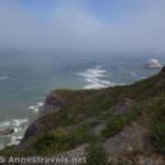
If there is a more beautiful place on the California coast than Point Arena-Stornetta National Monument, I can’t imagine what it would look like. The trail through Point Arena-Stornetta takes day hikers through clifftop meadows of waving grasses and wildflowers to views of numerous sea stacks, cliffs, streams, bays, sea arches, and more, not to mention near-constant views of the Point Arena Lighthouse. And I even got to see my very first harbor seals. In the winter, it’s apparently also a great place to whale watch. It’s pretty lonely, which is all the better to me. The day I visited was even sunny. What more could I ask for?
Quick Stats for Point Arena-Stornetta National Monument
Point Arena-Stornetta is part of the larger California Coastal National Monument, added in 2014 by President Obama. So I hear from another hiker who attended the ceremony, as the (then) Secretary of the Interior, Sally Jewell, was speaking at the official dedication of the monument, a whale breached right behind her. Quite the way to have a ceremony, especially considering that this section is the only land-based part of California Coastal National Monument!
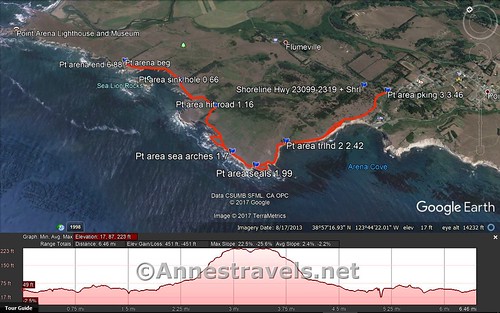
There are three (or four) parking areas for accessing the trail along the cliffs. Since we wanted the most beauty for our hiking we could get, we started from a small lot along the Point Arena Lighthouse Road (some signs call this “Bend in the Road Footpath Access”). There’s not a lot there besides a hefty drop off the pavement to the dirt lot, a port-a-potti, and a turnstile in the fence.
The area is still used for cows, and though I didn’t see any cows or evidence of them, you still might want to keep an eye on your feet.
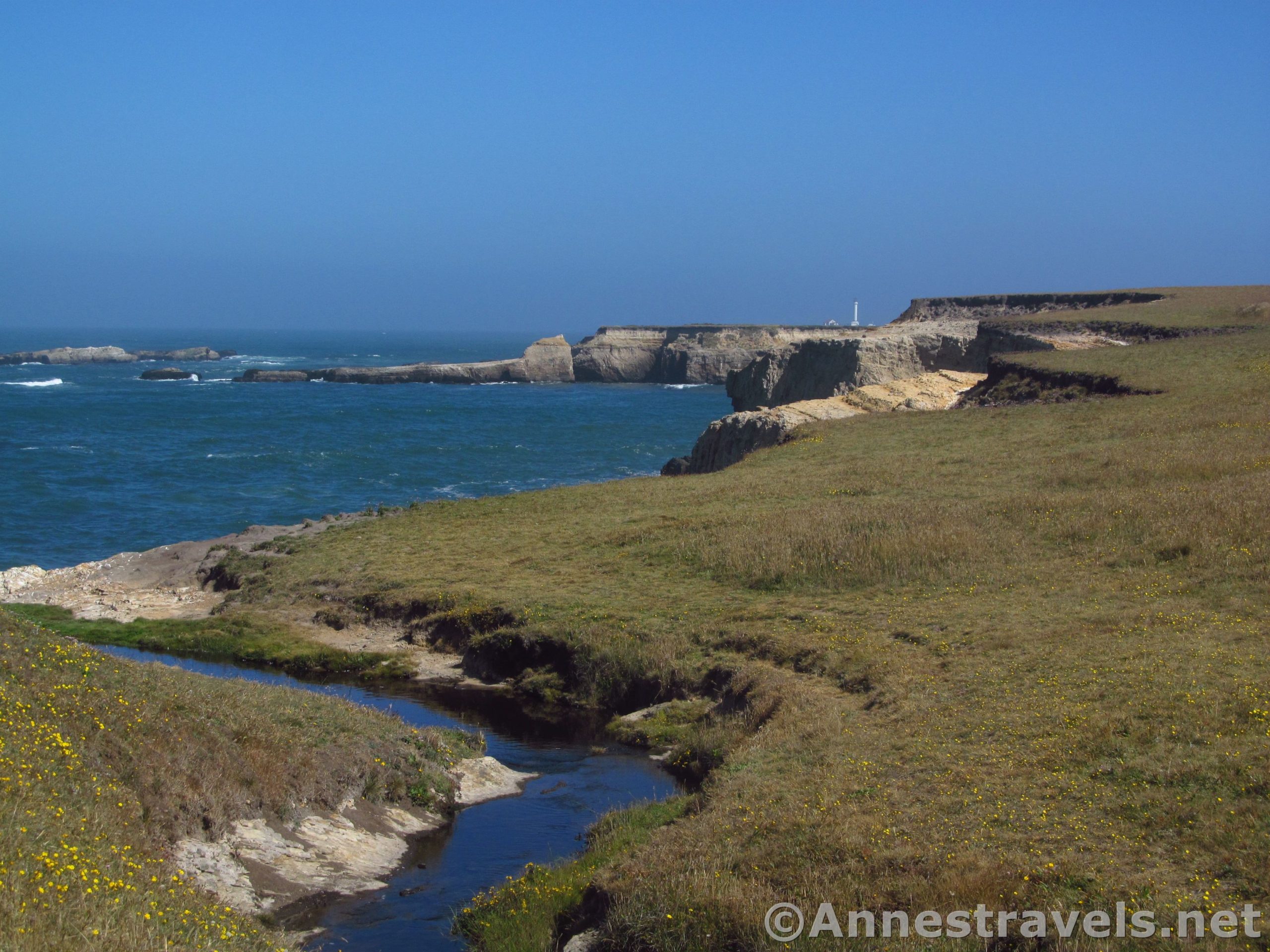
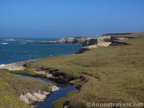
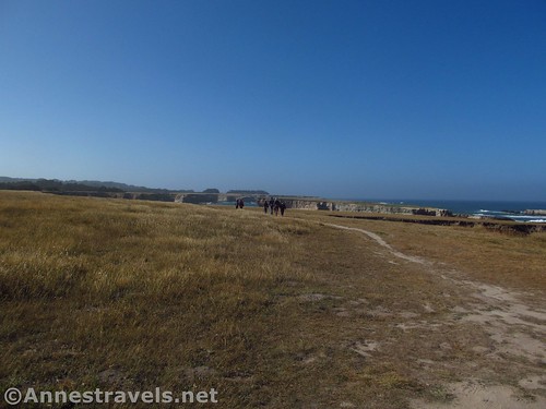
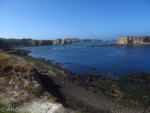
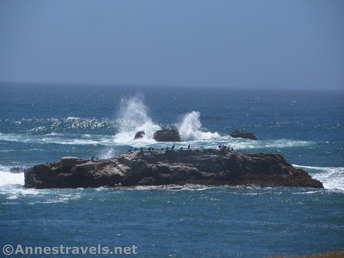
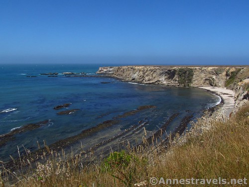
The trail descends slightly through the meadows of the headlands toward outstanding views of the Sea Lion Rocks (which mostly looks like a huge sea stack – and I mean huge – that is separated from the land by the sea).
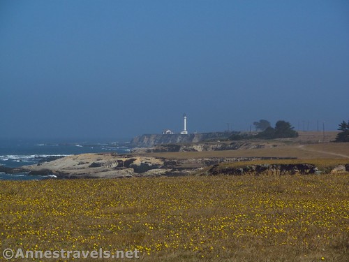
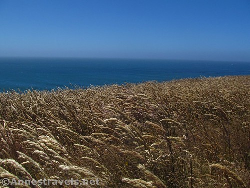
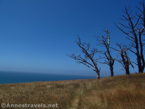
It then wanders along the coast, always on the cliff top, nearly always with views out to sea and back toward the Point Arena Lighthouse, though a few stands of trees occasionally block the view.
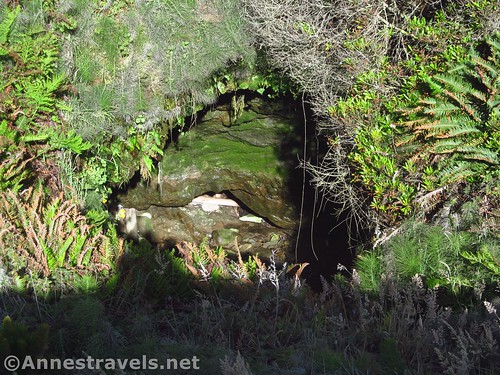
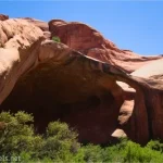
The first thing of real interest we found along the trail was a sink hole, 0.6 miles from the trailhead. It looks like it goes down into a cave that goes out to the ocean. However, there wasn’t any water visible, even at high tide. You can hear the sea gurgling, though.
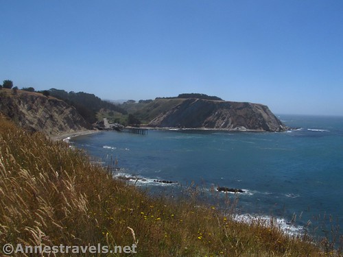
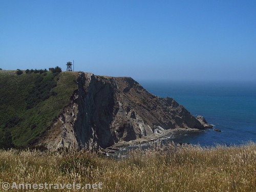
Wandering on, the trail descends to cross a little stream, then rises again to the top of the headland. On the right is an old Coast Guard station – it’s for sale, but is currently in the hands of Mendocino College as a Coastal Field Station. The trail veers inland to go around this, hitting the road to the station at about mile 1.1.
You could also park at the beginning of this road (right near where Lighthouse Road intersects with CA-1) and walk down the road to this place, but that’s about 0.9 miles, so you’ve only saved yourself 0.2 miles and you’ve missed a lot of good views.
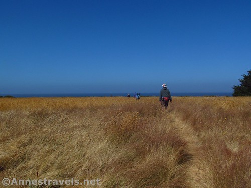
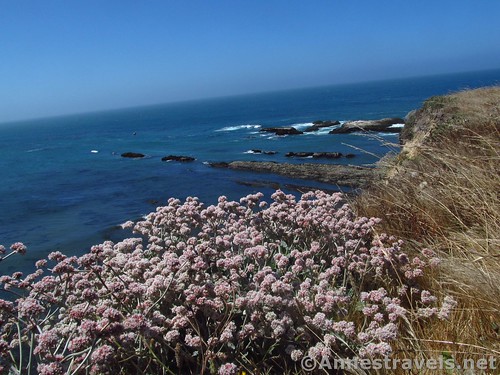
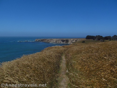
Turn right toward the station; a short distance later, the trail goes left back out onto the headlands. It fairly quickly gets back to the edge of the cliffs, and here the real views begin, because you’re now walking along the edge of the cliffs. (As if the views you’ve had so far haven’t already been enough!)
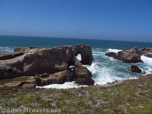
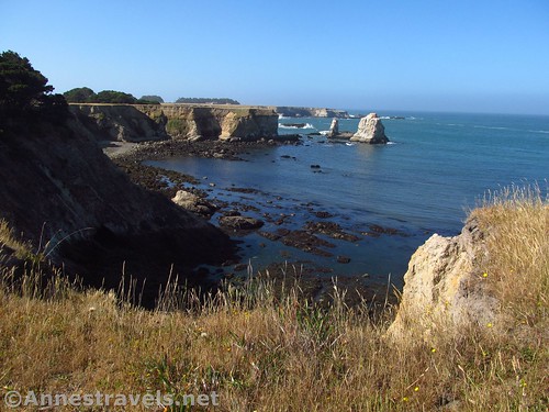
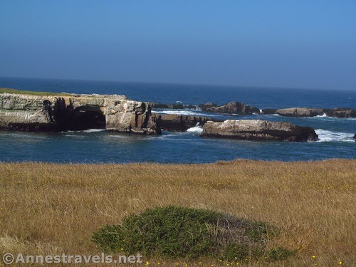
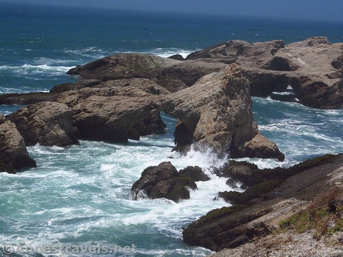
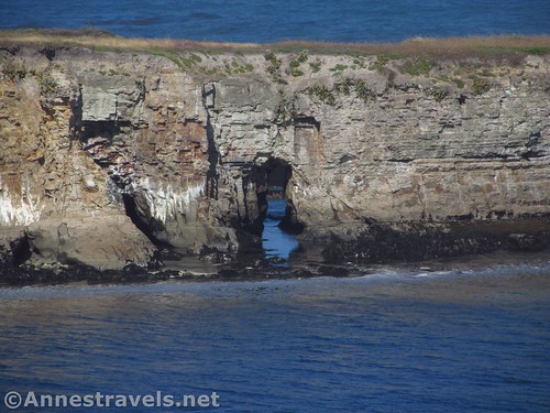
The headland views continue with waving grasses and occasional wildflowers; the views out to sea and back toward the lighthouse are great. But now also are a collection of sea stacks, many with sea arches.
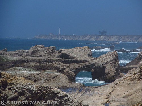
I counted at least seven sea arches; there are probably more. The sight of these at high tide, with the waves crashing around the arches, is quite something!
About 0.6 miles beyond the road is a kind of viewpoint of the arches from an outcropping on the headland. This is the end of the arches, but they are still incredible!
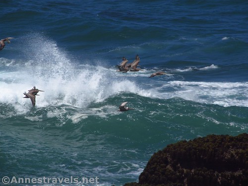
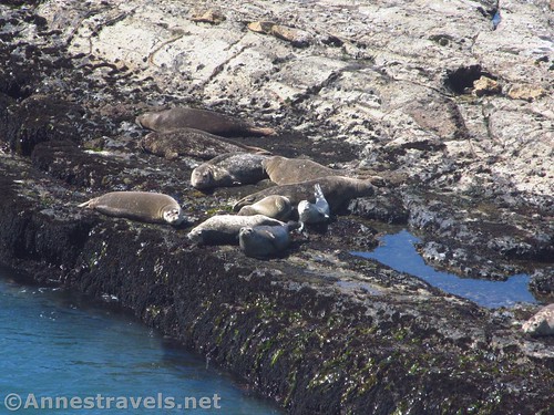
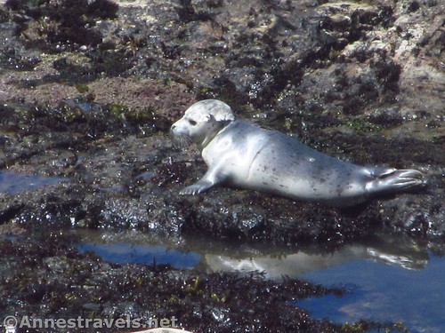
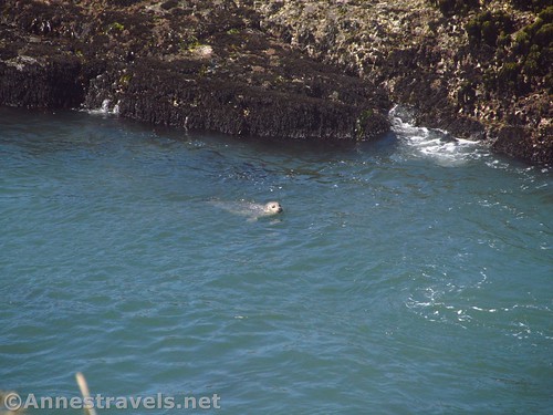
We kept walking another quarter mile, then settled down on the grassy clifftop, right near the edge. Down below was a rocky expanse cut off from the cliffs by the ocean. About 15 harbor seals were sunning themselves or playing in the water. How cool is that? I’ve never seen a harbor seal outside of a zoo!
Just after this, the trail (and headland) takes a sharp turn to the left, inland. You’ve seen the best of the views, but keep going for another 0.4 miles for more views of bays below sheer cliffs and more rocky “bars” in the ocean.
At mile 2.4, you’ll pass a parking area with a port-a-potti. It’s anyone’s guess whether the gate at the head of this road will be open so you could park there, but the road is located just north of the sign for the Point Arena city limits, with the Lion’s Club and Rotary Club signs.
At this point you really have seen the best views. However, if you want to finish out the trail and see a few more views down into the bay / pier (Point Arena Warf) / lookout tower and across the meadows, continue along the trail another mile to the final parking area, located next to the Point Arena City Hall and Justice Court. There wasn’t much going on when we were there, but there was a port-a-potti and a fairly large parking lot.
Go back the way you came for a total of 6.8 miles RT, or you can do this as a shuttle hike. Take your pick – the views are terrific any way you decide to do it!
You can also continue up the road another mile from the Bend in the Road Footpath Access to the Point Arena Lighthouse Overlook!
Round Trip Length: 6.8 miles
Net Elevation Change: About 189ft., most of which is gained at the southern end of the trail, which ends at 209ft.
Total Elevation Change: About 425ft.
Facilities: Port-a-potties at the trailheads
Fees: None, though if you go up to the lighthouse, there is a fee to enter the lighthouse grounds.
Trail Notes: There aren’t any guardrails, so use caution. You’ll have to cross a few streams; these should be easy rock-hops unless they’re really raging. Also look out for the evidence of cows. There are other paths intersecting this one and going further from the cliffs. This is probably good for those with vertigo…
Trail 
![]()
![]()
Road ![]()
Signs ![]()
![]()
Scenery
Would I go 100 miles out of my way for this?
Overall Rating: ![]()
Key GPS Coordinates for Point Arena-Stornetta National Monument
Trailhead: 38.9402722°N, -123.7298639°W (38°56’24.98″N, -123°43’47.51″W / 38°56.41633’N, -123°43.79183’W) (43ft.) (0.0; ended 6.88)
Sink Hole: 38.9333000°N, -123.7257083°W (38°55’59.88″N, -123°43’32.55″W / 38°55.99800’N, -123°43.54250’W) (53ft.) (0.66)
Trail Hits Road: 38.9276361°N, -123.7245472°W (38°55’39.49″N, -123°43’28.37″W / 38°55.65817’N, -123°43.47283’W) (54ft.) (1.16)
Sea Arches Viewpoint: 38.9218750°N, -123.7277028°W (38°55’18.75″N, -123°43’39.73″W / 38°55.31250’N, -123°43.66217’W) (37ft.) (1.7)
Seals Overlook: 38.9190333°N, -123.7266639°W (38°55’8.52″N, -123°43’35.99″W / 38°55.14200’N, -123°43.59983’W) (45ft.) (1.99)
Trailhead 2: 38.9190861°N, -123.7211667°W (38°55’8.71″N, -123°43’16.20″W / 38°55.14517’N, -123°43.27000’W) (79ft.) (2.42)
Coordinates of road to get to Trailhead 2: 38.9185944°N, -123.7060111°W (38°55’6.94″N, -123°42’21.64″W / 38°55.11567’N, -123°42.36067’W)
Trailhead 3: 38.9163472°N, -123.7041667°W (38°54’58.85″N, -123°42’15.00″W / 38°54.98083’N, -123°42.25000’W) (209ft.) (3.46)
The gpx file for Point Arena-Stornetta can be downloaded – please note that this and the GPS Coordinates are for reference only and should not be used as a sole resource when hiking this trail.
Download GPX File size: 98.6 KB Downloaded 497 times
(Note: I do my best to ensure that all downloads, the webpage, etc. are virus-free and accurate; however, I cannot be held responsible for any damage that might result, including but not limited to loss of data, damages to hardware, harm to users, from use of files, information, etc. from this website. Thanks!)
Getting to the Point Arena-Stornetta Parking Area
You’ll want to follow CA-1 north or south to get to Lighthouse Road, which is about 1.7 miles north of Point Arena, and about 22 miles south of where CA-128 connects to CA-1. Turn onto Lighthouse Road, following signs for the Point Arena Lighthouse. After 1.4 miles, just before the road turns sharply north toward the lighthouse, park in the small parking area along the fence.
If you’re going to the southernmost parking area, drive north through Point Arena; just before the city limits, park next to the City Hall and Justice Court. Or drive south to the Point Arena City Limits; shortly afterward, park next to the City Hall and Justice Court. The trail begins behind the building.
Zoom map out to browse nearby hikes & places of interest
This Week’s Featured Product!
Looking for more hikes along the northern California coast? Check out this book with 75 off-the-beaten-path hikes along the coastline and redwoods.
One response to “Hiking Point Arena-Stornetta National Monument”
[…] real destination that day was a very new national monument, Point Arena-Stornetta. All I can say is that I doubt there is a more beautiful section of the California coast. […]