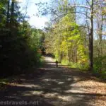
One of my favorite hikes I did around New York State last fall was the Whirlpool Trail Whirlpool State Park (though it might as well be in Niagara Falls State Park given how close it is to the falls – the trail goes right along the Niagara River) and Devils Hole State Park. The initial part of the trail is extremely steep – and then at the end, you have to hike out of the gorge, so that’s steep, too – but it’s worth the hundreds of stairs to follow an old rail line along the Niagara River past the Whirlpool and up to an old viewpoint of some truly impressive rapids. If you want to extend your hike a little (it’s easy and flat!), you can take the rim trail along the gorge to see where you just hiked – only from above!
Quick Stats
Note: Some of the links in this post are affiliate links. If you click one and purchase something, I may earn a small commission without an extra cost to you.
We parked at the Devil’s Hole State Park parking area. Actually, we got properly lost on our way there; we’re used to the Niagara Scenic Parkway’s old name of the Robert Moses State Parkway, so without the usual road name, we lost our way. I finally pulled over in a deserted parking lot to get out my hiking GPS and see if we could figure out where in the world we were and how to get to where I knew we wanted to be!
The parking area at Devils Hole State Park is medium-sized; big enough for maybe a couple of dozen vehicles on each side of the parkway. There was some construction going on at the time, so there may be a walkway across the parkway before long.
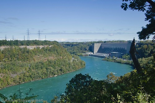
We went over to the trail on the rim of the gorge. You can see the hydroelectric plant in Lewiston quite well from here. Turn right (north) and walk along the paved path. After a tenth of a mile, turn left down the many flights of stairs – if there is a sign (I forgot to take a picture – grrr!) it will point down toward the Devil’s Hole.
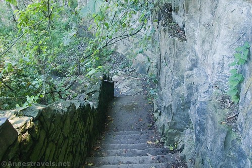
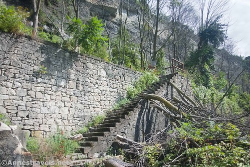
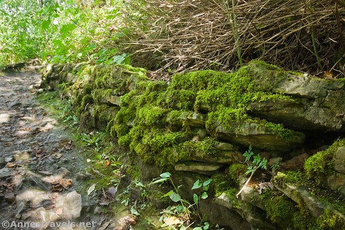
This part of the trail is extremely steep; you’re walking from the top of the gorge to the bottom of the gorge (200+ feet) in a quarter mile. My knees did not appreciate this part! The good news is that it’s pretty quickly done and over with, and then the trail is mostly flat (though there are some rough sections later – we’ll deal with that in a minute).

At the bottom of the stairs, turn left. I’m not 100% sure where the right trail goes (probably down toward the dam until there are no trespassing signs), but the left trail takes you through the woods with the Niagara River on your right. You’re getting the less-interesting part of the hike over with first, though there are occasional views out onto the river.

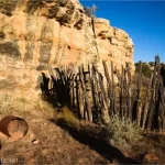
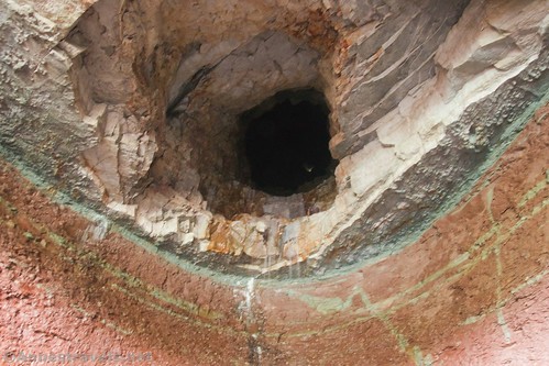
At 0.75 miles, the Devil’s Hole is on your left. It’s actually pretty cool; you can scramble up a steep trail to get up to it and go inside if you want to. I’ve heard that it’s been trashed pretty badly by college students, but it wasn’t too bad in late September of 2021. The Hole is named for the fact that a small waterfall tumbles down from seemingly nowhere and lands in the back of the cave. Pretty strange, right?

Actually, I could see a pinprick of light by looking up the hole. I’m not sure where it ends, but it comes from somewhere! Turning around and looking back out of the cave is nice, too.
We scrambled back down to the path and continued upstream along the Niagara River mostly through the trees. There were a few fall wildflowers and it was so wet and cloudy that a few of the leaves were covered in dewdrops. That was pretty.

At 1.6 miles, the trail down from Whirlpool State Park comes in on the left (this will be your return trail) with a stone picnic table nearby. Continue straight along the bottom of the gorge. The traffic picks up quite a bit after this junction, but on a Friday in September, it didn’t feel overly crowded. Most of the people were families or couples, though I did see a few single hikers.

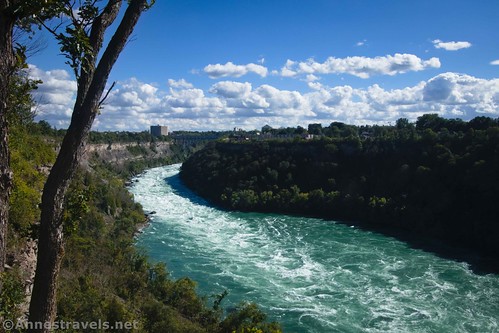
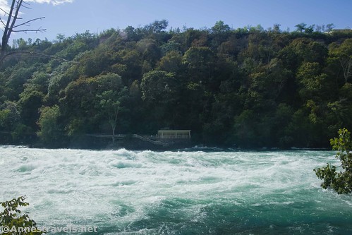
At times, the trail is rough or has stone steps. Watch your footing! The river also becomes rougher as you walk upstream. At last, you’ll come into view of the Whirlpool – which from here just looks like a wide part of the river.
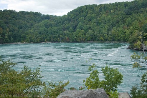
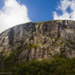
You can also see the Aerial Tram as it goes over the Whirlpool on its cable, both terminals for the tram, and what seems to be a zipline course on the Canadian rim of the Niagara Gorge. Sort of touristy, though you’re more or less in the wilderness on the US side!

Keep walking past the Whirlpool. This is where most people stop, but to see the best of the trail, you really need to keep going. Do not go down to river level, no matter the number of trails that do go down there – the river is deceptively dangerous. The trail becomes rougher and rougher, but it’s never too difficult to follow (though a few spurs do go off down toward the river). At times you’ll be scrambling over rocks; other times, the trail is on a concrete slab.
This route was once the bed of the Niagara Gorge Railroad which ran along the Niagara River from Niagara Falls, New York to Lewiston, New York from 1895 to 1935. Visitors could ride the trolley cars for $1 (about $30 today) in a loop in conjunction with the Niagara Gorge Belt Loop. Even William McKinley, his wife, and his entourage took the route in September of 1901. The route was often the victim of rock slides, which cut into the profits of the rail company (200,000 passengers on average per year helped, though!) In September of 1935, a slide was so destructive that the railroad was closed. For more information, you can visit Wikipedia (lots of pictures!) and Niagarafallsinfo.com.

About mile 3.7, there are some large rocks that make a great place to enjoy the rapids. Some of the waves are 40+ feet tall from what I could tell standing on the rocks above the river. We sat down here to eat lunch. I think two people passed us while we ate.

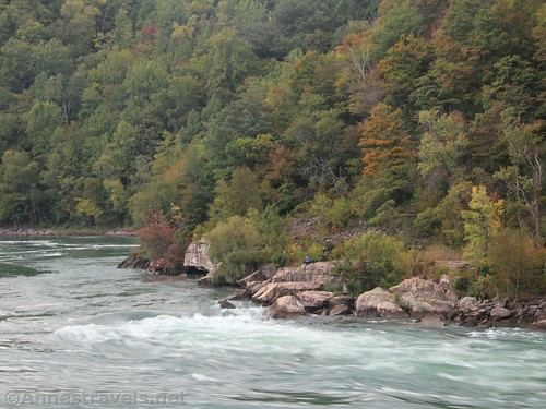
Keep walking between two large rocks and then along the rail bed. Views continue to improve of the Niagara River (there aren’t so many trees here) and the Whirlpool Rapids Bridge.
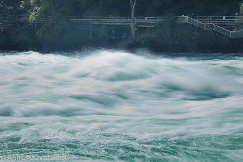
At 1.3 miles from the stairs down from Whirlpool State Park, the trail reaches what’s obviously an old viewpoint. I’m guessing that this was one of the stops along the Niagara Belt Loop. There’s an upper concrete platform on the level with the trail (be careful; I wouldn’t trust the railings) and concrete stairs (no railings – yikes!) that take you down to a lower viewpoint. It’s so worth hiking to get to this point!
You can look across the river and see the White Water Walk on the Canadian side. I’ve heard from friends that this is a great hike, but really, I can’t imagine it being better than this ramble!
At his point, the sun, which had been sulking most of our hike behind gray clouds (we were hoping against rain!) decided to come out. Gorgeous! While the views were definitely better with the sunshine, the photos of the river were almost better in the clouds. Interesting how that works.

You can’t go much further than the viewpoints. Signs just out of sight say that it’s the end of the trail; don’t go any further; danger; all that. I’d say some people do go further, but I’d rather respect the park people. So we turned around.

On our way back, we met two or three other groups (a family of 3 and a couple at least). We mostly had the trail to ourselves until the Whirlpool.

At the stairway back up to Whirlpool State Park, we turned right and began ascending the stairs, which were repaired in 2015. It’s quite a haul back up, but at least they’re in good shape!
At the top, instead of turning left to return to the Devil’s Hole Parking Area, we turned right to continue along the top of the Niagara Gorge. We met several people along the way, some on bikes since the path is paved. The views from up here are great.

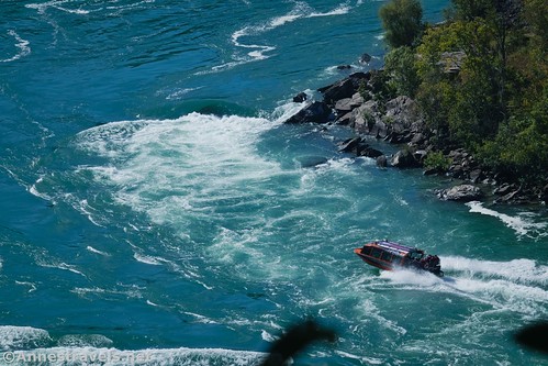
Besides the Whirlpool, there are also views of the Whirlpool Rapids Bridge. Keep your eyes open for the Jet Boat Tours that take people up into The Whirlpool. We had seen a few while we were down in the gorge, but never in a place to get a good photo. As it happened, as we walked along, we happened to be in the right place at the right time to get a photo of both the Jet Boat and the Whirlpool Aero Car – that was fun!

We went about 1.3 miles, then we turned around. We were both tired from all those stairs and we knew we had to drive back home, too. It’s about 0.9 miles (all flat and pavement) from the top of the stairs in Whirlpool State Park back to the Devil’s Hole State Park parking area – and there aren’t much in the way of views along the way, though you can occasionally see the gorge or the Lewiston power plant.

Overall, we did 7.9 miles. Most of it wasn’t too difficult, though those staircases were challenging for sure. But the views were well worth the trek, and on some of it, you might even have the trail to yourself!
Overall Trail Length: 7.9 mile loop with spurs
Elevation Gain: 2,485ft. (583ft. to 292ft.)
Facilities: There was a port-a-potty at Devil’s Hole State Park and probably another at Whirlpool State Park (definitely a bigger deal, with a playground, picnic area, etc.). Once you’re in the gorge, there are no facilities except for the stone picnic table near the bottom of the stairs in Whirlpool State Park.
Fees: None

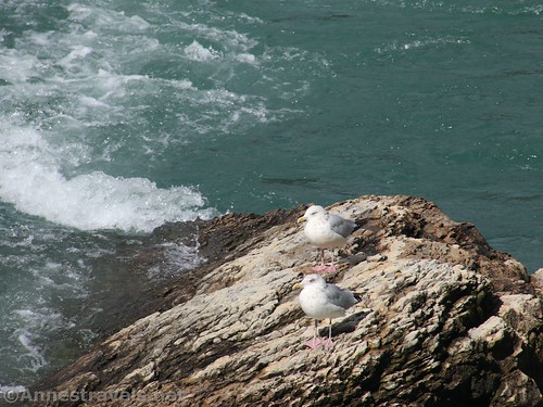
Trail Notes: There were quite a few people fishing – I gather that’s what most of the social trails down to the Niagara River are about. Be physically prepared for the steep staircases and wear sturdy shoes. Watch your footing as the trail is often rough. I found walking on the old railroad to be so much fun – but maybe that’s just because I like old railroads!
Note: As of this posting, the stairs in Whirlpool State Park are being repaired. They may be closed until June 2022.

Trail 
![]()
![]()
Road ![]()
Signs ![]()
![]()
Scenery
Would I go 100 miles out of my way for this?
Overall Rating: ![]()

GPS Coordinates for Whirlpool State Park
Devils Hole Trailhead: 43.133050,-79.048012 (43°07.98300′, -079°02.88072′ / 43°07’58.9800″, -079°02’52.8432″) (542ft.) (0.0)
Devils Hole Stairs: 43.133856,-79.046598 (43°08.03136′, -079°02.79588′ / 43°08’01.8816″, -079°02’47.7528″) (532ft.) (0.11)
Bottom of Devils Hole Stairs: 43.135135,-79.046366 (43°08.10810′, -079°02.78196′ / 43°08’06.4860″, -079°02’46.9176″) (306ft.) (0.39)

Cave: 43.132072,-79.050789 (43°07.92432′, -079°03.04734′ / 43°07’55.4592″, -079°03’02.8404″) (318ft.) (0.72)
Bottom of Whirlpool State Park Stairs: 43.125034,-79.059927 (43°07.50204′, -079°03.59562′ / 3°07’30.1224″, -079°03’35.7372″) (343ft.) (1.61)
Lunch rock: 43.115857,-79.061068 (43°06.95142′, -079°03.66408′ / 43°06’57.0852″, -079°03’39.8448″) (442ft.) (3.67)
End of trail: 43.114320,-79.059748 (43°06.85920′, -079°03.58488′ / 43°06’51.5520″, -079°03’35.0928″) (380ft.) (2.89)

Return to Whirlpool State Park Stairs: 43.125046,-79.059934 (43°07.50276′, -079°03.59604′ / 43°07’30.1656″, -079°03’35.7624″) (341ft.) (4.21)
Top of stairs in Whirlpool State Park: 43.124178,-79.059373 (43°07.45068′, -079°03.56238′ / 43°07’27.0408″, -079°03’33.7428″) (543ft.) (4.45)
Near the Whirlpool Viewpoint: 43.120485,-79.066067 (43°07.22910′, -079°03.96402′ / 43°07’13.7460″, -079°03’57.8412″) (528ft.) (4.91)
Turn around on rim trail: 43.112114,-79.057565 (43°06.72684′, -079°03.45390′ / 43°06’43.6104″, -079°03’27.2340″) (525ft.) (5.72)
Return to Devils Hole Parking Area: 43.133040,-79.048048 (43°07.98240′, -079°02.88288′ / 43°07’58.9440″, -079°02’52.9728″) (541ft.) (7.86)
The gpx file for my loop through Devil’s Hole State Park and Whirlpool State Park can be downloaded – please note that this and the GPS Coordinates are for reference only and should not be used as a sole resource when hiking this trail.
Download GPX File size: 135.0 KB Downloaded 359 times
(Note: I do my best to ensure that all downloads, the webpage, etc. are virus-free and accurate; however, I cannot be held responsible for any damage that might result, including but not limited to loss of data, damages to hardware, harm to users, from use of files, information, etc. from this website. Thanks!)

Getting to Devil’s Hole State Park/Whirlpool State Park
From I-90, take Exit 53 to I-190N. After 27.4 miles, take Exit 25B toward NY-104 and the Niagara Scenic Byway (formally the Robert Moses Parkway). Merge onto Upper Mountain Road for 0.4 miles, then keep left, following signs for the Niagara Scenic Parkway (formally the Robert Moses Parkway – sorry, but that’s what I know it as, and any long-term travelers to Niagara Falls will be mightily confused if they think they’re looking for one and only find the other!) Take the Niagara Scenic Parkway for 1.4 miles and then take the exit toward Devil’s Hole and park in the parking area. If you want to continue down to Whirlpool State Park, just keep driving another mile down Niagara Scenic Parkway and then turn right at the sign for Whirlpool State Park.

This Week’s Featured Product!
There are a ton of trails in this guide – from well-known walks to hidden gems. The guide is slightly old, but it’s still great.