I hiked Artist Point about 7 years ago. The view was spectacular, like nothing else in the world, and so worth doing. However, I couldn’t say the same for the trail. The path up from the Tunnel View parking area was narrow, eroded, and extremely, extremely steep, only to lose elevation after junctioning with the Old Carriage Road. So when I visited Yosemite last summer, I thought I’d try a different route simply ascending the Old Carriage Road, therefore having a bottom-up experience instead of a top-down experience. I figured it couldn’t be any harder than what we’d done last time.
Quick Stats for Artist Point via the Old Carriage Road
(Affiliate links are present on this page.)
About the trail, I was right. It’s a much easier and more deserted way to go.
However, parking in Yosemite is no easy feat. I finally managed to do it at Bridal Veil Falls, and if you’re off-season, or very early in the day, that might work for you. However, if you’re in the middle of the day, or if it’s even smacking of summer, you’d be better off parking along the road, near where they Old Carriage Road departs. It would save you miles of walking, too.
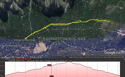
If you park in the Bridal Veil Falls, walk up the road 0.3 miles to where the inauspicious and unmarked Old Carriage Road heads off into the woods on your left. You won’t miss it, so don’t worry about every deer trail that seems to maybe, perhaps, go somewhere.
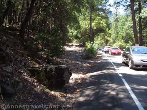
If you want to park along the road, the Old Carriage Road begins at 37.7151722°N, -119.6562278°W (other formats at the bottom of the page). Coming from Wawona, it’s 1.3 miles after Tunnel View and just before the sign saying “Reduced Speed Ahead”. Coming from the valley, it’s just before a sign saying “No Passing Next 26 Miles”, 0.3 miles beyond the parking area for Bridal Veil Falls. There is a small, unmarked pullout directly across the road from the Old Carriage Road.
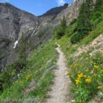
Once you start up the Old Carriage Road, the world seems to drift away, even if you can still hear traffic on the Wawona Road below you. The old road climbs steadily uphill, occasionally crossing small trickles or larger streams, with peek-a-boo views down the valley. The trail is rough and rocky in places, but not bad for hiking.
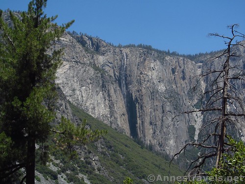
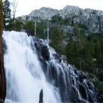
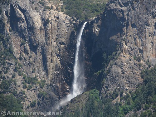
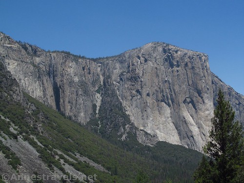
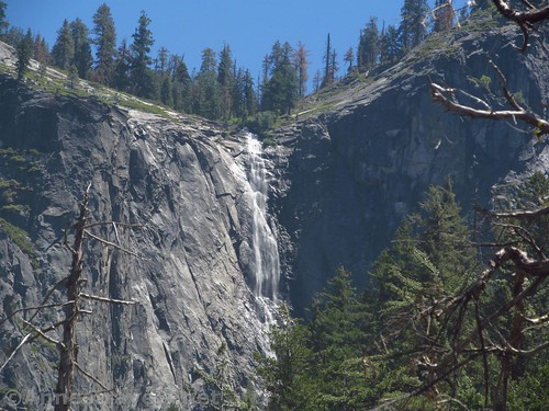
After 0.8 miles, a view into the valley offers fairly good views of a waterfall descending the cliffs just west of El Capitan. My GPS called it an “Intermittent Cataract”. With no better name, my group christened it “MUSIC Falls” (Misty Undulating Silver Intermittent Cataract). Topo maps on the internet give it the less exciting, if more accurate, title of Ribbon Falls.
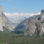
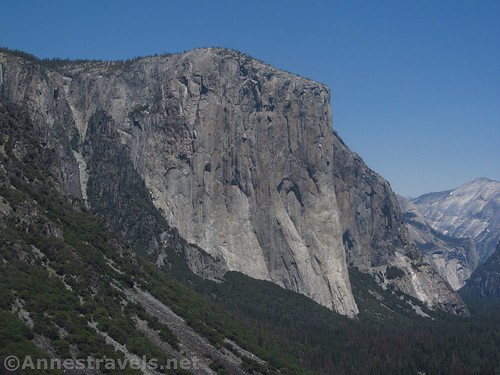
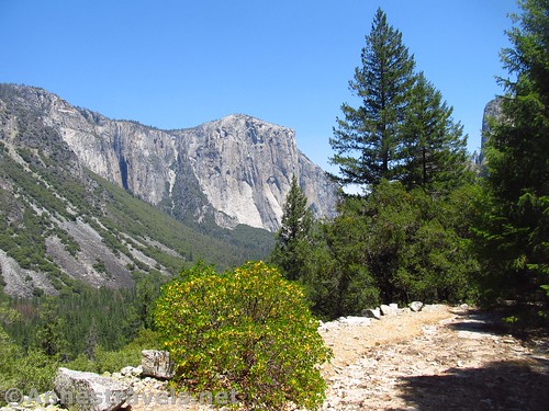
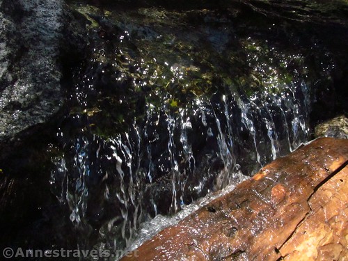
Continuing along, views peek-a-boo of El Capitan and occasionally Yosemite Valley. Keep hiking upward (you won’t lose the trail; it’s always the old road) to an open space at mile 1.6. Just before this is 1) an open space with slightly limited views, and 2) a waterfall / small stream (Artist Creek) that runs through a culvert. To the right are the views, along with a number of large rocks, and to the left are slickrock-like rocks that make up the hillside.
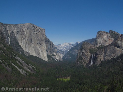
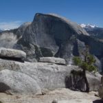
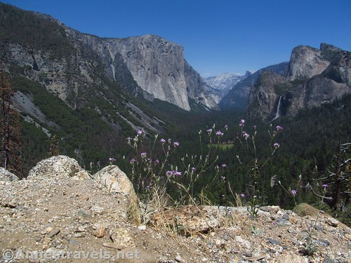
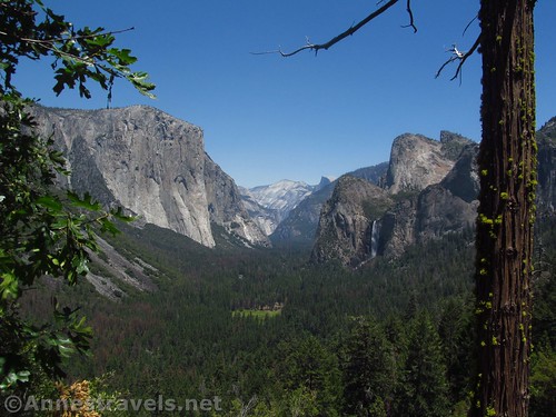
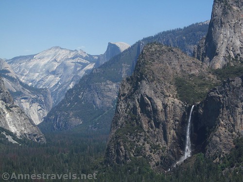
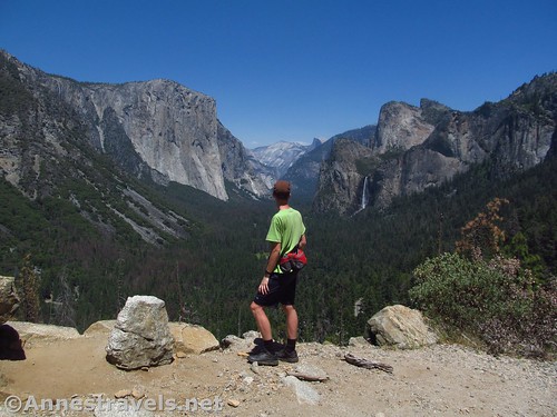
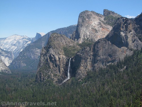
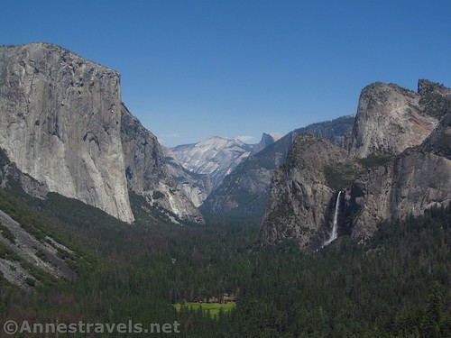
And the views! It’s like a higher, better version of Tunnel View, with El Capitan, Yosemite Valley, Half Dome, Clouds Rest, Cathedral Rocks, and Bridal Veil Falls starring. I could stare at it for hours!
Retrace your steps to your vehicle, or you could continue for a bit up the Old Carriage Road. Turn downward (right) at the trail junction 0.5 miles later to hike the 0.5 miles to Tunnel View (more on that route here). Or continue another mile to reintersect the same trail (Pohono Trail, according to Google) a mile later near Inspiration Point. The Pohono Trail ascends relentlessly, but it also has stunning views of the valley from Crocker Point, Dewey Point, Taft Point, and Sentinel Dome before ending at Glacier Point. At which point, you could always descend the famed, knee-jolting Four Mile Trail back down into the valley. But since the Pohono Trail is 13 miles one way, and the Four Mile Trail is, well, more than 4 miles one way, that would be one long day hike!
Round Trip Length: About 3.0 miles up the Old Carriage Road and back, plus any mileage to get to the beginning of the trail (add 0.6 miles total if you park at Bridal Veil Falls)
Net Elevation Change: 518ft. (4,166ft. at the beginning of the Old Carriage Road to 4,684ft. at Artist Point)
Facilities: None. There are restrooms (with exceedingly long lines) and a few picnic tables at Bridal Veil Falls.
Fees: $30/vehicle, valid 7 days. It has been proposed that prime-season visitors be charged $70/vehicle. Either are waived with America the Beautiful Interagency Passes: Annual, Senior, Access, Volunteer, Military, 4th Grader, etc., as well as Yosemite National Park Annual Pass.
Trail Notes: The trail isn’t frequented, though on 4th of July Weekend I saw maybe half a dozen other groups. Most had no clue Artist Point existed and were just hiking the trail for fun. Be prepared, and wear good shoes, since the road is pretty rocky.
Trail 
![]()
![]()
Road ![]()
Signs ![]()
![]()
![]()
![]()
Scenery
Would I go 100 miles out of my way for this?
Overall Rating: 
![]()
Key GPS Coordinates
Bridal Veil Falls parking area: 37.7165917°N, -119.6519667°W (37°42’59.73″N, -119°39’7.08″W / 37°42.99550’N, -119°39.11800’W) (3,988ft.)
Beginning of Old Carriage Road: 37.7151722°N, -119.6562278°W (37°42’54.62″N, -119°39’22.42″W / 37°42.91033’N, -119°39.37367’W) (4,166ft.) (0.0; ended 3.26)
Waterfall view: 37.7120111°N, -119.6652028°W (37°42’43.24″N, -119°39’54.73″W / 37°42.72067’N, -119°39.91217’W) (4,363ft.) (0.8) (Misty Undulating Silver Intermittent Cataract (MUSIC Falls) / Ribbon Falls)
Artist Point: 37.7126694°N, -119.6753333°W (37°42’45.61″N, -119°40’31.20″W / 37°42.76017’N, -119°40.52000’W) (4,684ft.) (Arrived 1.66; left 1.94)
The gpx file for Artist Point via the Old Carriage Road can be downloaded – please note that this and the GPS Coordinates are for reference only and should not be used as a sole resource when hiking this trail.
File size: 57.8 KB Downloaded 0 times
(Note: I do my best to ensure that all downloads, the webpage, etc. are virus-free and accurate; however, I cannot be held responsible for any damage that might result, including but not limited to loss of data, damages to hardware, harm to users, from use of files, information, etc. from this website. Thanks!)
Getting to the Trailhead for the Old Carriage Road
From the El Portal Road, take the Southside Drive almost 1 mile; turn right onto the Wawona Road, following signs for Wawona and Fresno. Park in the parking area for Bridal Veil Falls, directly after the turn, then walk 0.3 miles up the road, or continue 0.3 miles up the road to the beginning of the trail.
From Yosemite Valley, take the Northside Drive to its junction with the El Portal Road; turn right onto the Southside Drive (singed for Wawona and Fresno) and follow the directions above.
From Wawona, take the Wawona Road 21 miles to the trailhead.
Zoom map out to browse nearby hikes & places of interest
This Week’s Featured Product!
The trails in this book are for day hikers, but they offer a truly wide variety for just about every skill level, in just about every region of the park.