
Last week was a “staycation” for me. Every day felt like, “we can’t possibly see something today as nice as yesterday” and yet it always was! Who knew there were so many places spectacular with fall colors this close to home? One of my favorite days was biking a loop around Canadice Lake in the western Finger Lakes of New York. With the autumn color just coming out, paddlers on the lake, and a great trail (that felt downhill most of the way – I don’t know how that works) it’s a beautiful place to be in the fall or any time of year.
Quick Stats
(Affiliate links are present on this page.)

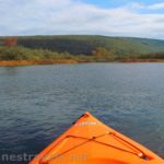
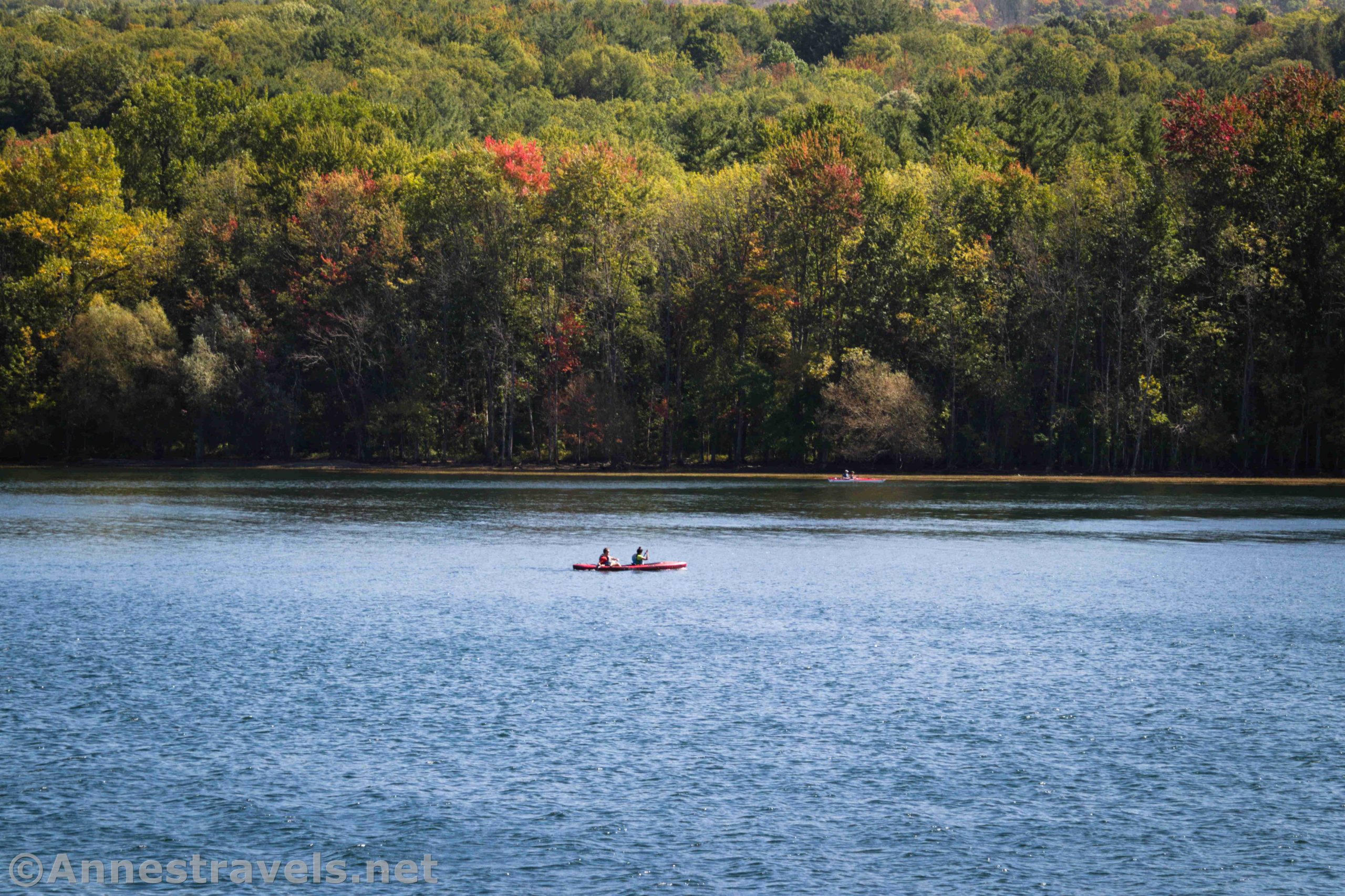
One of the special things about Canadice Lake is that it’s not built up. As part of the water supply for Rochester, New York, regulations went into effect very early on about what you could and could not do in it and along its shores – and building cottages was a real no-no. Boating, swimming, camping, and horse use was also prohibited until recently, when non-motorized boats were grudgingly allowed. At this point, it’s very likely you’ll run across paddlers on the lake on a nice day.

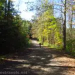
We started from a parking area at the north end of the lake. There’s space for about a dozen cars here, a port-a-potty, and a signboard. Walk (or ride) up the parking area and go through the gate to begin down the old Canadice Lake Haul Road.

At first, the road rolls a bit and passes by a few buildings (probably something to do with the water supply). It enters the forest and winds its way along the lakeshore. The tread is definitely a dirt road, but it’s hard-packed (at least during the current drought) and made for easy bike riding or walking. Before too long, the trail is mostly downhill.

You’ll pass by Rob’s Trail on the right about mile 1.6. I missed it entirely on our ride, but technically you could climb this up to Rt-15A via this trail.

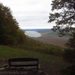
The views are mostly peek-a-boo through the trees until you get toward the southern end of the lake. Then a couple of good views open up across the lake and toward the southern end. The trees at the southern end were all in full fall color when I visited in late September, so these views were beautiful! (The trees at the northern end were barely showing even a streak of color.) We also saw some paddlers out on the lake.

At the southern end of Canadice Lake, the trail takes a sharp turn to the left and passes by some wetland trails. Keep going up the steep hill to Canadice Lake Road at mile 4.0.

At this point, you have a couple of options. If you’re hiking, you probably just want to turn around and retrace your steps back to the parking area. However, if you’re on bikes, you have the option of turning left and taking the road to loop around Canadice Lake back to the parking area. That’s what we decided to do, and we didn’t regret our decision. In fact, we felt like we were going downhill most of the way on the trail and downhill most of the way on the road… I don’t know how that works since we returned exactly to our starting point! But hey, I’ll take it!

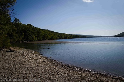
One of the great things about going by the road is that there are a few trails down to the lake, and the beaches tend to be pretty peaceful. The first trail down to the lake is 0.8 miles from the Canadice Lake Road Trailhead. It’s a very nice beach with views toward the northern end of the lake.

The second trail down is actually a popular boat launch. There’s a good-sized beach with views across the lake. In fact of matter, there are more than two trails down to the lake, but these seem to be the most popular/best maintained.

Most of the good views are before or between the two trails. By the time you get up toward the northern end of the lake, trees block the lake from view. But there are some cute cottages on the opposite side of the road. Be sure to take the left turn on Percell Hill Road to drop down over the Canadice Lake Outlet – the parking area is on the left just after the outlet.

Overall, it’s just a pleasant bike ride. The hills do pose a slight challenge, but it’s not too bad. It’s also a great hike – especially in the fall when the trees turn color.

Overall Trail Length: 8.0 miles out & back or 8.25 mile loop (includes walking down to the beach and the boat launch)
Elevation gain: 959ft. (1,095ft. to 1,180ft.)
Facilities: Possibly a port-a-potty at the trailhead. Boat launches are not too far away.
Fees: None
Trail Notes: This trail is best in the autumn, but you can see the lake more after the leaves are off the trees. It would also be very nice in the spring (it might be muddy, but probably not too bad).
Trail 
![]()
Road ![]()
Signs ![]()
![]()
Scenery ![]()
Would I go 100 miles out of my way for this? ![]()
Overall Rating: ![]()
GPS Coordinates for the Canadice Lake Haul Road Trail
North Trailhead: 42.7436333°, -077.5736000° (N42° 44.618′ W77° 34.416′ / 42°44’37.0800″, -077°34’24.9600″) (1,143ft.) (0.0)
South Trailhead: 42.6916833°, -077.5690500° (N42° 41.501′ W77° 34.143′ / 42°41’30.0600″, -077°34’08.5800″) (1,152ft.) (4.00)
Beach: 42.7028167°, -077.5659167° (N42° 42.169′ W77° 33.955′ / 42°42’10.1400″, -077°33’57.3000″) (1,138ft.) (4.86)
Boat launch: 42.7240500°, -077.5648833° (N42° 43.443′ W77° 33.893′ / 42°43’26.5800″, -077°33’53.5800″) (1,141ft.) (6.50)
End: 42.7438500°, -077.5736167° (N42° 44.631′ W77° 34.417′ / 42°44’37.8600″, -077°34’25.0200″) (1,151ft.) (8.24)

The gpx file for the Canadice Lake Loop can be downloaded – please note that this and the GPS Coordinates are for reference only and should not be used as a sole resource when hiking this trail.
Download GPX File size: 43.9 KB Downloaded 533 times
(Note: I do my best to ensure that all downloads, the webpage, etc. are virus-free and accurate; however, I cannot be held responsible for any damage that might result, including but not limited to loss of data, damages to hardware, harm to users, from use of files, information, etc. from this website. Thanks!)

Getting to the Canadice Lake Haul Road Trailhead
From I-390, take Exit 8 (it may be signed for Lakeville/Conesus Lake or for Geneseo). Turn to drive east on US-20A. Stay on US-20A by taking a slight right after 1.7 miles. Two miles later, turn right onto Big Tree Street for 3.4 miles; turn right onto NY-15A. After 4.4 miles, turn left onto Purcell Hill Road. At the bottom of the hill (aka 1.2 miles later), turn right into the parking area.
From Canandaigua, take US-20A West. Stay on US-20A W when it turns left about 5 miles outside of town. About 3.7 miles later, turn right to continue on US-20A W for another 10.5 miles. Shortly before the town of Hemlock, turn left onto Canadice Lake Road for 3.4 miles, then turn right onto Purcell Hill Road. Do not go up the hill; turn left after 0.2 miles into the parking area.
Note: If you want to get to the trailhead on Canadice Lake Road (south end of the lake), go to the T on Purcell Hill Road just east of the parking area. Turn southward on Canadice Lake Road about 3.7 miles to the trailhead, on the right.

This Week’s Featured Product!
If it hadn’t been for this book, I probably wouldn’t have hiked this trail. There are tons of biking ideas, from roads to smooth paths to mountain bike trails, of varied lengths. I highly recommend it!