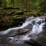

You might recall that a couple of weeks ago, I posted about hiking the Falls Trail through Ganoga Glen in Ricketts Glen State Park. Well, here’s the final installment of that post – the Falls Trail through Glen Leigh! The two glens are usually hiked together as a loop and showcase at least 21 cascades – truly a paradise for those of us who love waterfalls!
Quick Stats
Note: Some of the links in this post are affiliate links. If you click one and purchase something, I may earn a small commission without an extra cost to you.
There are two main parking areas for Ricketts Glen. The most popular is the Lake Rose Trailhead near the park office, since it’s the shortest option and very convenient for the loop of Ganoga Glen and Glen Leigh, with Midway Crevasse as a fun little diversion along the way. The more traditional parking area is the Evergreen Parking/Glens Lot Trailhead Parking to the south. The good thing about this longer route is that you get to see an additional three waterfalls that aren’t on the loop. You can also park at Beach Lot #2 if both of the other lots are full. Click on “Falls Trail System Guide (PDF)” for a good map of the area at this link.
There’s some debate about which way you should hike the loop. I opted to descend Ganoga Glen and ascend Glen Leigh, catching Midway Crevasse on my way back to the parking area. It doesn’t really matter which way you do it; some prefer to get to the falls quickly (me) and then take the forest part (through Midway Crevasse) when they’re tired. Others like to do the boring part of the hike first and then have waterfalls beckoning them when they’re tired (opposite to the way I hiked it). It’s really up to you, but I’ll be describing the route up Glen Leigh from Waters Meet – where the two forks of Kitchen Creek (Ganoga Glen and Glen Leigh) meet to form one stream – and then back to the Lake Rose Parking Area via Midway Crevasse.
Here’s a quick chart of the waterfalls in Glen Leigh (beginning with Waters Meet). I’ll detail my hike below this.
| Cumulative mileage | Distance (approx.) | Waterfall name | Height |
| 3.59 | 0.0 | Wyandot Falls | 15ft. |
| 3.64 | 0.1 | B. Reynolds Falls | 40ft. |
| 3.91 | 0.4 | R.B. Ricketts Falls | 36ft. |
| 4.19 | 0.25 | Ozone Falls | 60ft. |
| 4.48 | 0.3 | Huron Falls | 41ft. |
| 4.58 | 0.1 | Shawnee Falls | 30ft. |
| 4.82 | 0.25 | F.S. Ricketts Falls | 39ft. |
| 5.11 | 0.3 | Onondaga Falls | 15ft. |
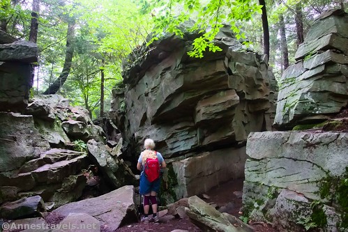
| 6.05 | 0.9 | Midway Crevasse | N/A |
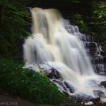
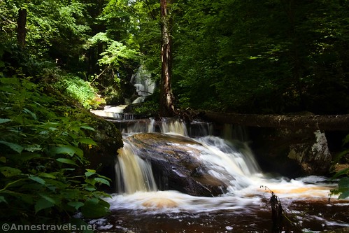
Cross the bridge (at Waters Meet) to begin up Glen Leigh. Actually, before crossing the bridge, continue downstream a very short distance so you can look up Glen Leigh to the first waterfall – Wyandot Falls, only 15ft. tall.
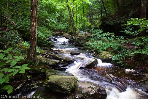
Continue a tenth of a mile or so beyond Wyandot Falls up to B. Reynolds Falls (40ft. tall). It’s cool because the trail makes its way up to pass right next to the lip of the falls. After three days of rain, the water wasn’t across the trail – but I expect it could be during a large rainstorm! Watch your footing, as the rock can be pretty wet.

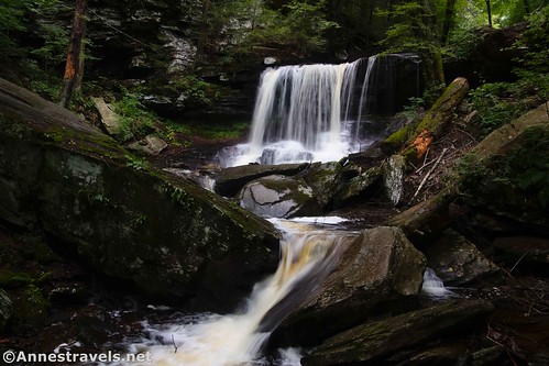
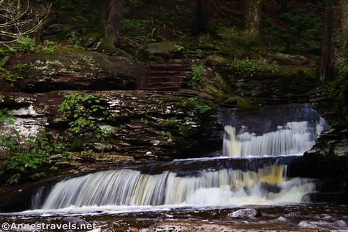
R.B. Ricketts Falls is about 0.4 miles further upstream (there are several smaller falls along the way). At 36ft. tall, it’s unique for the fact that it looks like two falls – one in the main stream and the other coming in from the right.
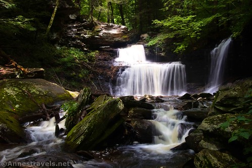
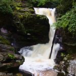
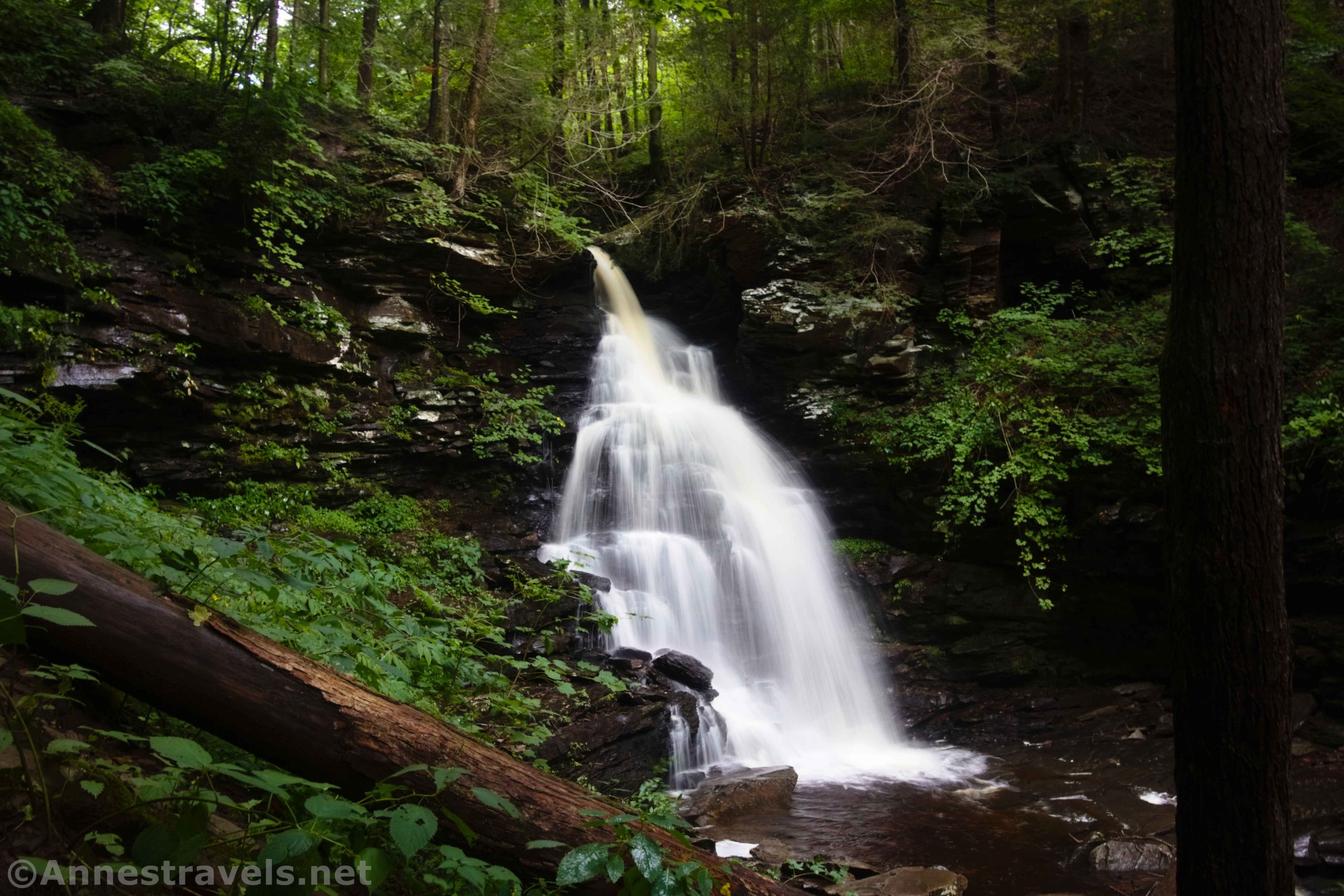
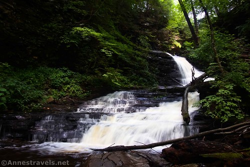
A quarter mile up the trail is the tallest waterfall in Glen Leigh – and also one of my favorites. Ozone Falls is 60ft. tall and set in a lovely green glen!
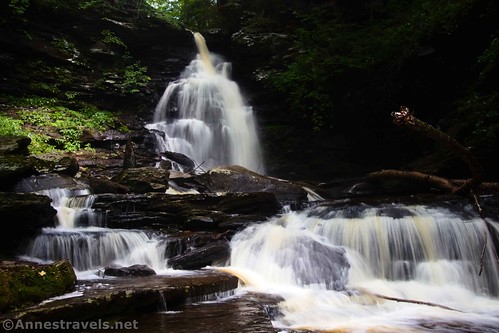
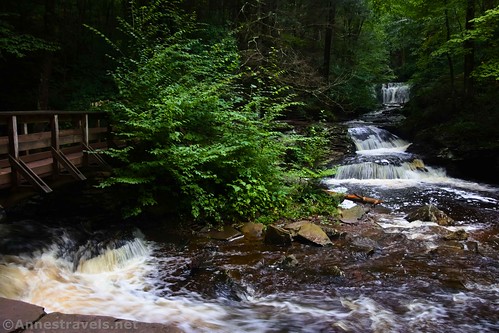
The trail ascends steeply to regain water level above Ozone Falls. About 0.3 miles beyond the base of Ozone Falls, you’ll come to Huron Falls (41ft.). It’s pretty in part because of the rustic stone steps along the right side.

Climb the steps up to Shawnee Falls, 0.1 miles later.

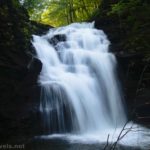
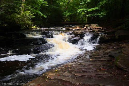
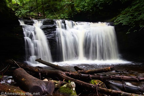
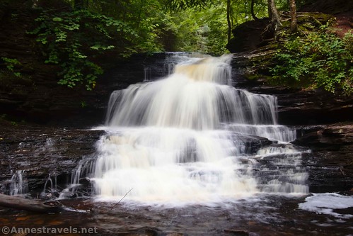
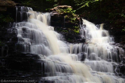
Perhaps the prettiest waterfall in Glen Leigh is a quarter mile upstream from Shawnee Falls. F.L. Ricketts Falls (38ft.) is incredibly shapely with dozens of tiny drops. We sat down just to enjoy the view for a few minutes; it’s that pretty!

Again, the trail climbs steeply. But this time, you have a decision to make. A shortcut trail rises out of Glen Leigh and up to the Highland Trail 0.2 miles beyond the bottom of F.L. Ricketts Falls. This is a steeper, shorter alternative for returning to the parking area. It also skips one (granted, not quite as exciting) waterfall. The choice is yours, but I opted to hike up to the last falls.

Onondaga Falls (15ft.) is located a tenth of a mile upstream of the shortcut junction. It’s not as exciting as many, but I’m still glad I went up and saw it.
Keep walking another 0.2 miles to the junction with the Highland Trail. Turn left (following the sign for the Park Offices) and almost immediately leave the sound of the babbling stream behind you. I was a little sad to leave it – I’d seriously enjoyed all of the waterfalls and the beauty of the creek!
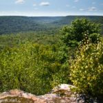
The Highland Trail is a quiet stroll through the forest. We saw almost no one, since most people who hike it either had done it earlier and were now going down Glen Leigh or else hadn’t yet made it back up to take the upper trail back to the parking area.
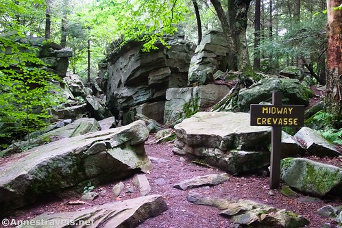
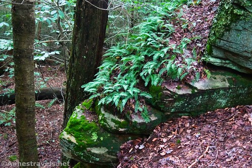
Pass by the top of the shortcut trail 0.2 miles later and continue straight (follow the sign for Lake Rose). After about half a mile on the Highland Trail, you’ll come to Midway Crevasse. It’s just a jumble of huge rocks with a passage through the middle, but it is pretty fun!
The forest after this has a few more very large rocks and cliffs. I enjoyed the ferns (I love ferns!) and some of the rocks and tree roots, as well.

Return to where you turned for Ganoga Glen (remember that, on your way out earlier in the day?) a half a mile later; turn right to return to the parking area after about 0.2 miles.

And that’s the rest of the Falls Trail in Ricketts Glen! I can’t say I have a favorite of the two glens… both have spectacular falls. I can highly recommend the loop anytime the streams are full of water and the waterfalls, flowing in all their beauty!

Round Trip Trail Length: I did 6.6 miles around the entire loop and to the three other waterfalls south of Waters Meet
Elevation Gain: 2,559ft. (2,228ft. to 1,390ft.) (note that the elevation gain may be a little bit overestimated due to low GPS service in the area.)
Facilities: Restrooms at the trailhead
Fees: None

Trail Notes: Try to go after a rain for the best the waterfalls have to offer. The park can be insanely busy on weekends, especially when the falls are flowing well. One or both glens may be closed in the winter due to hazardous conditions, rockfalls, and the like. While the Lake Rose Trailhead is called “small,” it has room for at least 50-100 cars – it’s just too small for the number of people who want to park there! It did not fill up on the Thursday that I hiked, but weekends could be an issue. Swimming is not allowed.
Trail 
![]()
![]()
Road ![]()
Signs
Scenery
Would I go 100 miles out of my way for this?
Overall Rating: 

GPS Coordinates for Falls Trail (Ganoga Glen & Glen Leigh)
Trailhead: 41.329782000, -76.290593000 (41°19.78692′, -076°17.43558′ / 41°19’47.2152″, -076°17’26.1348″) (2,217ft.) (0.0)
Begin loop: 41.328548000, -76.288344000 (41°19.71288′, -076°17.30064′ / 41°19’42.7728″, -076°17’18.0384″) (2,214ft.) (0.16)
Beaver Junction: 41.326444000, -76.288400000 (41°19.58664′, -076°17.30400′ / 41°19’35.1984″, -076°17’18.2400″) (2,166ft.) (0.34)
Mohawk Falls: 41.326556000, -76.287266000 (41°19.59336′, -076°17.23596′ / 41°19’35.6016″, -076°17’14.1576″) (2,117ft.) (0.48)
Unnamed Falls: 41.326247000, -76.286621000 (41°19.57482′, -076°17.19726′ / 41°19’34.4892″, -076°17’11.8356″) (2,091ft.) (0.54)
Oneida Falls: 41.325765000, -76.285515000 (41°19.54590′, -076°17.13090′ / 41°19’32.7540″, -076°17’07.8540″) (2,067ft.) (0.64)
Cayuga Falls: 41.324952000, -76.284223000 (41°19.49712′, -076°17.05338′ / 41°19’29.8272″, -076°17’03.2028″) (2,030ft.) (0.75)
Top of Genoga Falls: 41.323868000, -76.283650000 (41°19.43208′, -076°17.01900′ / 41°19’25.9248″, -076°17’01.1400″) (2,011ft.) (0.87)
Old Beaver Trail Junction: 41.323186000, -76.283958000 (41°19.39116′, -076°17.03748′ / 41°19’23.4696″, -076°17’02.2488″) (2,017ft.) (0.94)
Bottom of Genoga Falls: 41.323599000, -76.283418000 (41°19.41594′, -076°17.00508′ / 41°19’24.9564″, -076°17’00.3048″) (1,930ft.) (1.09)
Delaware Falls: 41.322274000, -76.282939000 (41°19.33644′, -076°16.97634′ / 41°19’20.1864″, -076°16’58.5804″) (1,910ft.) (1.37)

Mohican Falls: 41.321791000, -76.282724000 (41°19.30746′, -076°16.96344′ / 41°19’18.4476″, -076°16’57.8064″) (1,868ft.) (1.50)
Conestoga Falls: 41.3213880°, -076.2811450° (41°19.28328′, -076°16.86870′ / 41°19’16.9968″, -076°16’52.1220″) (1,760ft.) (1.61)
Tuscarora Falls: 41.321796000, -76.279165000 (41°19.30776′, -076°16.74990′ / 41°19’18.4656″, -076°16’44.9940″) (1,773ft.) (1.74)
Erie Falls: 41.321772000, -76.277010000 (41°19.30632′, -076°16.62060′ / 41°19’18.3792″, -076°16’37.2360″) (1,652ft.) (2.03)
Waters Meet: 41.321278000, -76.275380000 (41°19.27668′, -076°16.52280′ / 41°19’16.6008″, -076°16’31.3680″) (1,579ft.) (2.31)
Harrison Falls: 41.318735000, -76.274143000 (41°19.12410′, -076°16.44858′ / 41°19’07.4460″, -076°16’26.9148″) (1,516ft.) (2.65)
Sheldon Falls: 41.317783000, -76.273660000 (41°19.06698′, -076°16.41960′ / 41°19’04.0188″, -076°16’25.1760″) (1,466ft.) (2.79)
Upper/Lower Trail Junction: 41.316326000, -76.273142000 (41°18.97956′, -076°16.38852′ / 41°18’58.7736″, -076°16’23.3112″) (1,472ft.) (2.94)
Murray Falls: 41.316326000, -76.273142000 (41°18.97956′, -076°16.38852′ / 41°18’58.7736″, -076°16’23.3112″) (1,451ft.) (2.98)
Wyandot Falls: 41.321838000, -76.275268000 (41°19.31028′, -076°16.51608′ / 41°19’18.6168″, -076°16’30.9648″) (1,648ft.) (3.59)
B. Reynolds Falls: 41.330237000, -76.273468000 (41°19.81422′, -076°16.40808′ / 41°19’48.8532″, -076°16’24.4848″) (1.665ft.) (3.64)
R.B. Ricketts Falls: 41.324014000, -76.274494000 (41°19.44084′, -076°16.46964′ / 41°19’26.4504″, -076°16’28.1784″) (1,804ft.) (3.91)
Ozone Falls: 41.325364000, -76.274675000 (41°19.52184′, -076°16.48050′ / 41°19’31.3104″, -076°16’28.8300″) (1,875ft.) (4.19)
Huron Falls: 41.327733000, -76.274154000 (41°19.66398′, -076°16.44924′ / 41°19’39.8388″, -076°16’26.9544″) (1,947ft.) (4.48)
Shawnee Falls: 41.328179000, -76.273997000 (41°19.69074′, -076°16.43982′ / 41°19’41.4444″, -076°16’26.3892″) (2,002ft.) (4.58)
F.S. Ricketts: 41.330237000, -76.273468000 (41°19.81422′, -076°16.40808′ / 41°19’48.8532″, -076°16’24.4848″) (2,047ft.) (4.82)
Shortcut Junction: 41.330507000, -76.273720000 (41°19.83042′, -076°16.42320′ / 41°19’49.8252″, -076°16’25.3920″) (2,127ft.) (5.00)
Onondaga Falls: 41.331156000, -76.273440000 (41°19.86936′, -076°16.40640′ / 41°19’52.1616″, -076°16’24.3840″) (2,112ft.) (5.11)
Shortcut Junction: 41.331084000, -76.274778000 (41°19.86504′, -076°16.48668′ / 41°19’51.9024″, -076°16’29.2008″) (2,163ft.) (5.55)
Midway Crevasse: 41.329122000, -76.281825000 (41°19.74732′, -076°16.90950′ / 41°19’44.8392″, -076°16’54.5700″) (2,266ft.) (6.05)
Return to loop junction: 41.328572000, -76.288358000 (41°19.71432′, -076°17.30148′ / 41°19’42.8592″, -076°17’18.0888″) (2,251ft.) (6.48)
End: 41.329764000, -76.290631000 (41°19.78584′, -076°17.43786′ / 41°19’47.1504″, -076°17’26.2716″) (2,263ft.) (6.63)
The gpx file for the Falls Trail in Ricketts Glen can be downloaded – please note that this and the GPS Coordinates are for reference only and should not be used as a sole resource when hiking this trail.
Download GPX File size: 117.3 KB Downloaded 458 times
(Note: I do my best to ensure that all downloads, the webpage, etc. are virus-free and accurate; however, I cannot be held responsible for any damage that might result, including but not limited to loss of data, damages to hardware, harm to users, from use of files, information, etc. from this website. Thanks!)
Getting to the Lake Rose Trailhead (Ricketts Glen)
From I-180 (say, Williamsport), take Exit 15 toward US-220. Turn east on US-220N for 4.9 miles; turn right onto N Main Street for 0.3 miles. Turn left onto PA-118E (E Water Street). Drive 24.3 miles. Turn left onto PA-487N (a sign does point toward Ricketts Glen State Park, but it may be hard to see) for 3.7 miles. Take the road on the right into Ricketts Glen State Park; after 0.4 miles, you’ll need to turn right to continue another 0.6 miles down to the Lake Rose Trailhead at the end of the road.
From I-81 (say, Wilkes-Barre), take Exit 170 toward PA-309N (be sure it’s north, not south!). After 7.1 miles, turn left onto Hillside Road (signs point toward Penn State WB) for 3.2 miles. Then take a slight right onto Old Rte 115 for 0.9 miles, turn left to stay on Old Rte 115 for another mile, and then keep left again to stay on Old Rte 115 for another 1.5 miles. Turn left onto PA-118W. After 14.5 miles, turn right onto PA-487N (a sign does point toward Ricketts Glen State Park, but it may be hard to see) for 3.7 miles. Take the road on the right into Ricketts Glen State Park; after 0.4 miles, you’ll need to turn right to continue another 0.6 miles down to the Lake Rose Trailhead at the end of the road.

This Week’s Featured Product!
Waterfall lovers, perk up! This book takes you to more than 50 of the best waterfalls that can be found in Pennsylvania. From gentle strolls to longer treks, there are quite a lot of cascades to behold. Buy your copy here!