

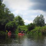
Last week, we decided unexpectedly to take a kayak trip. We thought about doing another paddle on Black Creek (or maybe downstream from the Churchville Dam), but I’d had my eye on Honeoye Creek for some time. It seemed like another great stream to explore, and (unlike most times when we’re out kayaking) it was supposed to be warm enough that we didn’t mind getting wet. That’s a good thing, since Honeoye Creek, even when it’s somewhat full of water, will make you portage at least twice – and you might find yourself dragging your kayak up or down rapids if the water is low!
Quick Stats
The book where I found the kayak trip down Honeoye Creek said that it wasn’t accessible until midsummer. That’s not altogether true. I did it in mid-June after a couple of heavy rainstorms. Paddling upstream was real work, but otherwise, the stream was a fantastic place to spend a day on the water – even with higher water levels.
Let me say before I begin and that I don’t necessarily recommend paddling up Honeoye (pronounced honey-oye) Creek. It’s perfectly doable, especially if you have strong arms and shoulders. But the current is strong – you’re much better off doing this as a shuttle paddle, with a vehicle at either Rush or I-390 and another where we started near the railroad bridge on Golah Road. So all that to say, I’m going to describe the route the way you shouldn’t do it – from the bottom up. You can read about my trip on Honeoye Creek from Rush to Golah Road here.

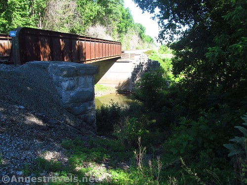
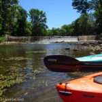
We put in under the railroad bridge at Golah Road. There’s a small gravel parking area between the power station and the railroad tracks (be careful not to park on the ballast, which is very large gravel and might damage your tires). From here, you can walk down a very steep but doable trail down under the bridge. The slope down into the water is even steeper, and it’s muddy. But I didn’t see any poison ivy in the area. I managed to get in without getting my feet wet.

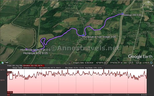
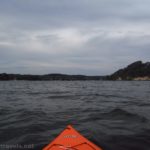
We paddled down to the Genesee River first. It’s only 0.15 miles down to the mouth of Honeoye Creek, where it empties into the Genesee. I turned up the Genesee for a short distance, then we went back up to the rail bridge. Note that there is one log jam between the bridge and the Genesee – in high-ish water, we were able to duck under the branches on the right side. In lower water, I hear you’ll have to portage it.

Heading upstream from the train bridge, you’ll almost immediately come to the first obstacle: a man-made rock dam. I remember three of these on the way up, but I only saw one on the way back down. So either I wasn’t watching carefully enough, or the dams grew in my mind. My paddling companion climbed out and pulled us both up and over these obstacles (the water was too fast to easily paddle up them).

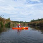
Honeoye Creek above these dams is nice and quiet. It twists and turns through the woods, sometimes shallower, sometimes deeper. The next excitement comes at 1.3 miles, at the first log jam. High water, low water, there seems to be no way around this one. You’ll have to pull over to the left side of the creek and portage via the trail (watch out for poison ivy – there is quite a bit here) around an uprooted tree or two and finally back down to the creek bank above the log jam. From here, you can see the second log jam, but the easiest thing to do is to paddle across the creek and walk on the sandbar around the right side of the log jam (in very high water, you may just be able to paddle around the right side).

Above the two log jams, Honeoye Creek is a varied mix of quiet, peaceful water and stretches of rapids (along with a couple of other small log jams that might need to be portaged in low water). None of the rapids are especially dangerous, but in low water, they could be impossible to paddle. Even in higher water, the shallow water and quickly moving current made paddling difficult. We ended up walking up most of the rapids, despite the fact that they were deep enough to shoot – which was exactly what we did on the way back down!

About this point, my kayaking companion’s water shoes self-destructed. I highly recommend close-toed shoes for this trek, and his were great until they fell apart! I’d purchased some really nice water shoes for hiking the Zion Narrows back in 2017, and thankfully they were still good enough to get us through this one. Sadly, those shoes are no longer made – I’d buy another pair!

We ate lunch on a rock beside the river just below the point where E River Road crosses Honeoye Creek just outside of West Rush. Once under the road, the creek calms down for a few minutes, then it goes up two more rapids. After this is a long stretch of quiet water. We chased (not intentionally!) a Great Blue Heron up the creek for some distance, almost all of the way to I-390.

I-390 is about4.7 miles up Honeoye Creek from where we’d started at the railroad bridge. There is a parking area here for the Lehigh Valley Trail (you drive down Fishnell Road to access the parking area), and people use it for putting in small crafts. We went slightly further up Honeoye Creek (just to within sight of the next rapids) and shared some caramel corn snack mix I’d packed (with half the brown sugar (of course!) and peanuts instead of pecans for protein). Not exactly great trail food, but tasty all the same. Then we headed back downstream.

Going downstream was tons of fun. Besides being easier to paddle, the rapids had the challenge of trying to figure out how to shoot them without scraping the kayak on the rocks. It’s all about reading the water and maneuvering your craft. Thankfully, my kayaks are pretty rugged, so when we did scrape or ram something (oops!) they handled it all right.

Overall, we spent about six hours on the water, not including the time we spent eating and resting. Of that, only two hours were coming back downstream. I’ve heard that you can start up in Rush, but that will be another exploration for another day… hopefully with a shuttle vehicle this time!

Round Trip Paddle Length: 4.9 mile shuttle or 10.0 miles out & back
Elevation Gain: About 27ft. (520ft. to 547ft.)
Facilities: None
Fees: None

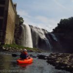
Paddle Notes: As I said above, this is a better downstream route than an out-and-back. Wear close-toed water shoes if you can – those rocks on the bottom are murder on the feet. Be ready to portage, especially at times of low water – chances are you’ll get your feet wet on this little expedition. Respect the rights of property owners along the creek, especially the railroad that owns the land either near or on where you’ll be parking the downstream shuttle vehicle. This stream is best explored with a hard-sided boat – the inflatable kind (or fabric-over-frame) has too much likelihood of being torn on a rock. If you have to explore with an inflatable boat, go downstream and enjoy a paddle on the Genesee River – the old Lehigh Valley Trail has a rail bridge a short way north of the mouth of Honeoye Creek.

Stream 
![]()
![]()
Road ![]()
Signs ![]()
![]()
![]()
![]()
Scenery ![]()
![]()
![]()
Would I go 100 miles out of my way for this? ![]()
![]()
Overall Rating: 
![]()
![]()

GPS Coordinates for Paddling Honeoye Creek
Launch Point: 42.9709528°, -077.7163417° (42°58’15.43″N, 77°42’58.83″W / 42°58’15.4300″, -077°42’58.8300″) (536ft.) (0.0)
Mouth of Honeoye Creek: 42.9712583°, -077.7187250° (42°58’16.53″N, 77°43’7.41″W / 42°58’16.5300″, -077°43’07.4100″) (522ft.) (0.15)
E River Road Bridge: 42.9778472°, -077.6988694° (42°58’40.25″N, 77°41’55.93″W / 42°58’40.2500″, -077°41’55.9300″) (534ft.) (3.06)
I-390/Fishnell Road Launch: 42.9900306°, -077.6801889° (42°59’24.11″N, 77°40’48.68″W / 42°59’24.1100″, -077°40’48.6800″) (541ft.) (5.00)
End: 42.9708278°, -077.7162278° (42°58’14.98″N, 77°42’58.42″W / 42°58’14.9800″, -077°42’58.4200″) (537ft.) (9.05)
The gpx file for Honeoye Creek from the Genesee to I-390 can be downloaded – please note that this and the GPS Coordinates are for reference only and should not be used as a sole resource when hiking this trail.
Download GPX File size: 133.5 KB Downloaded 325 times
(Note: I do my best to ensure that all downloads, the webpage, etc. are virus-free and accurate; however, I cannot be held responsible for any damage that might result, including but not limited to loss of data, damages to hardware, harm to users, from use of files, information, etc. from this website. Thanks!)
Getting to Honeoye Creek
From I-390, take Exit 11 toward NY-251 W and Scottsville. At the top of the exit ramp (if you’re coming from the north), continue straight to the next intersection; turn right on NY-251W. (If you’re coming from the south, just exit to NY-251 and turn left.) After 1.8 miles, turn left onto E River Road for 2.4 miles. Cross over Honeoye Creek on the bridge and enter West Rush. Just after the town, turn right on Golah Road. Drive 0.7 miles and park on the right just before the railroad tracks.
This Week’s Featured Product!
This is the best book I know of for paddling trails around western New York (including Rochester). The maps are the best part, but the descriptions are also helpful. Buy your copy here!

Pingback: Trail Snack – Caramel Corn Snack Mix (GF+DF) - Anne's Travels