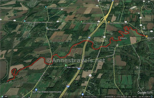
One summer day, a group of us decided to take a kayak trip on Honeoye Creek. I wrote in a previous post about starting at Golah Road and paddling up to I-390 and back. This time, we decided to leave a shuttle vehicle at Golah Road and begin even further upstream – at the dam in Rush. It was a fun summer day activity, but it’s not the easiest (nor hardest!) paddle I’ve ever done. There were several log jams, shallow places, and plenty of twists and turns. But as long as you’re not above getting out of your kayak and pulling it over the sholes (and log jams), it’s quite doable and even fun on a hot day!
Quick Stats

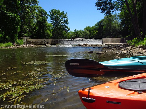
Because we got lost on our way to Rush (oops!), plus dropping off our shuttle vehicle, we didn’t get started until 11am. We parked in the lot set aside for the Veterans Memorial Park/Rush Station Parking for the Lehigh Valley Trail, dragged our kayaks down the grass, and wobbled down the rocky, leafy slope to launch the kayaks just below the dam. It’s not as easy as having a dock, but it’s not bad.

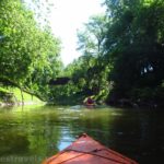
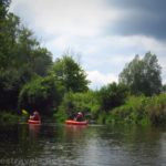
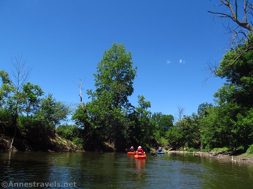
Honeoye Creek immediately passes under 15A (East Henrietta Road) and fairly quickly leaves civilization behind. It’s a pleasant ride downstream between treed banks or beside a grassy bank leading up into a farmer’s field.

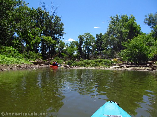
About 1.3 miles from Rush, the creek comes to its first real obstacle: A long and nasty section of a log jam. It has to be the longest jam I’ve ever run across. We dragged our kayaks, tipping from one log to the next, trying to find a way through. I believe one foot got wet; we found a bottle with a cork in it along with plenty of other trash (including a mannequin head… I didn’t get a picture of that) and finally made it through a thicket of tree branches to clear water on the other side. Yay!

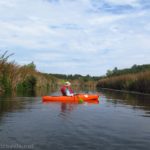
Keep going downstream. There are a few other log jams (including two about mile 1.5, another about mile 1.9; at least one of these I’d classify as “difficult”) and occasional shallow sections that may require you to get out of your craft if the water is low. But in general, it’s not too difficult.
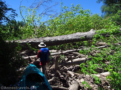
On one of the jams, one of my group members tried to pull up a kayak with a kayaker still in it onto the log. She just about flipped him into the creek! On another jam, the log beneath me rolled. Splash! One leg up to the knee. I got my footing, turned back to help a group member and, Splash! Same foot up to my thigh that time! Let’s just say that the log jams gave us plenty of opportunities for laughs.
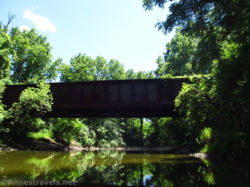
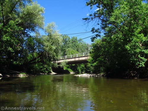
Pass under a railroad bridge (actually the Lehigh Valley Trail) about mile 2.1, then under West Henrietta Road about mile 3.5. About 0.6 miles later, you’ll come to the twin bridges that are I-390. I was very excited to get here since it meant I’d already kayaked the route ahead!

As I described here, the route after this has its own sets of shallows that will require you to get out and pull your kayak. But it’s a pleasant paddle/stream walk (more of the former than the latter, thankfully!) Pass under East River Road about mile 5.8.

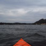
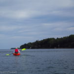
The river twists and turns and generally takes its good ol’ time getting down to the train bridge that marks Golah Road. Along the way, it passes over two more two log jams – about mile 7.25 and another a tenth of a mile later). Once under the train bridge, you could continue another 0.2 miles down to the Genesee River (no shallow sections, but there is one snag that could become a log jam).

Instead, we pulled up left (south) under the bridge (it’s a working railway – the Livonia, Avon, and Lakeville Railroad). A well-trod path heads up the east (left if your back is to the river) up around the bridge abutment to a small gravel parking area beside a transformer station. This was where we’d parked our shuttle vehicle, so two of us headed off to get the van while the others dragged the kayaks up the steep path to the parking area and sat down to enjoy a snack in (semi-) comfort while they waited for us!

Shuttle Route Length: 7.7 miles from Rush to Golah Road
Elevation gain: 9ft. (536ft. to 527ft.) Let’s just say that Honeoye Creek in this section doesn’t flow very fast!
Facilities: None along the way, though there might be a portable toilet under I-390. Rush has restaurants and (sometimes) portable toilets near the Lehigh Valley Trail. Veterans Memorial Park has a fishing platform.
Fees: None

Trail Notes: Water levels fluctuate. The number of times you’ll have to scramble a log jam or get out of your craft will be determined by how high the water is (how recently it’s rained). At Golah Road, don’t trespass on the railroad (private property), into the transformer station (private property), or onto the nearby fields (also private property). That said, there’s no reason you can’t use the parking area. Conditions change on creeks like this, so be prepared for new or bigger log jams, or jams that no longer exist because a flood took them out.

Route 
![]()
![]()
Road ![]()
Signs ![]()
![]()
![]()
![]()
Scenery ![]()
![]()
![]()
Would I go 100 miles out of my way for this? ![]()
![]()
![]()
Overall Rating: 
![]()
![]()

GPS Coordinates for Honeoye Creek: Rush to the Genesee River
Kayak launch in Rush: 42.9928500°, -077.6450610° (42°59.57100′, -077°38.70366′ / 42°59’34.2600″, -077°38’42.2196″) (536ft.) (0.0)
Long log jam: 42.9971070°, -077.6555620° (42°59.82642′, -077°39.33372′ / 42°59’49.5852″, -077°39’20.0232″) (533ft.) (1.34)
Log jam: 42.9959960°, -077.6542260° (42°59.75976′, -077°39.25356′ / 42°59’45.5856″, -077°39’15.2136″) (531ft.) (1.49)
Log jam: 42.9948230°, -077.6546230° (42°59.68938′, -077°39.27738′ / 42°59’41.3628″, -077°39’16.6428″) (531ft.) (1.58)
Log jam: 42.9959100°, -077.6600390° (42°59.75460′, -077°39.60234′ / 42°59’45.2760″, -077°39’36.1404″) (533ft.) (1.94)
Lehigh Valley Trail: 42.9930340°, -077.6583010° (42°59.58204′, -077°39.49806′ / 42°59’34.9224″, -077°39’29.8836″) (532ft.) (2.15)

West Henrietta Road: 42.9868180°, -077.6723150° (42°59.20908′, -077°40.33890′ / 42°59’12.5448″, -077°40’20.3340″) (530ft.) (3.49)
I-390: 42.9900010°, -077.6796430° (42°59.40006′, -077°40.77858′ / 42°59’24.0036″, -077°40’46.7148″) (528ft.) (4.18)
East River Road: 42.9779390°, -077.6989580° (42°58.67634′, -077°41.93748′ / 42°58’40.5804″, -077°41’56.2488″) (522ft.) (5.84)
Log jam: 42.9752610°, -077.7157750° (42°58.51566′, -077°42.94650′ / 42°58’30.9396″, -077°42’56.7900″) (523ft.) (5.25)
Log jam: 42.9740400°, -077.7152120° (42°58.44240′, -077°42.91272′ / 42°58’26.5440″, -077°42’54.7632″) (523ft.) (7.35)
Livonia, Avon, and Lakeville Train Bridge: 42.9709350°, -077.7162260° (42°58.25610′, -077°42.97356′ / 42°58’15.3660″, -077°42’58.4136″) (527ft.) (7.67)
Genesee River: 42.9713500°, -077.7187540° (42°58.28100′, -077°43.12524′ / 42°58’16.8600″, -077°43’07.5144″) (521ft.) (7.83)
The gpx file for Honeoye Creek (Rush to the Genesee) can be downloaded – please note that this and the GPS coordinates are for reference only and should not be used as a sole resource when hiking this trail.
Download GPX File size: 34.7 KB Downloaded 346 times
(Note: I do my best to ensure that all downloads, the webpage, etc. are virus-free and accurate; however, I cannot be held responsible for any damage that might result, including but not limited to loss of data, damages to hardware, harm to users, from use of files, information, etc. from this website. Thanks!)

Getting to Rush
Take I-390 to Exit 11 toward NY-251. If coming from the north (Rochester), turn left to the next crossroad; turn left on NY-251E (Rush Scottsville Road). If coming from the south (Dansville), turn right on NY-251 (Rush Scottsville Road). After 1.3 miles, turn right onto NY-15A S (East Henrietta Road). After 0.3 miles, turn left into the park area just after crossing Honeoye Creek.

Getting to Golah Road
From I-390, take Exit 11 toward NY-251 W and Scottsville. At the top of the exit ramp (if you’re coming from the north), continue straight to the next intersection; turn right on NY-251W. (If you’re coming from the south, just exit to NY-251 and turn left.) After 1.8 miles, turn left onto E River Road for 2.4 miles. Cross over Honeoye Creek on the bridge and enter West Rush. Just after the town, turn right on Golah Road. Drive 0.7 miles and park on the right just before the railroad tracks.
Getting between Golah Road and Rush
Take Golah Road back out to East River Road and turn left (north). Take the second right onto Rush West Rush Road for 3.1 miles. Turn left onto NY-15 A N (it’s a very strange intersection!) and turn right 0.1 miles later into the parking area just before crossing Honeoye Creek.
This Week’s Featured Product!
This is one of the best resources I know of about kayaking in western New York State! From ponds to rivers to adventures, the book covers quite a number of different paddling escapades in the Rochester and Buffalo areas. Buy your copy here!