

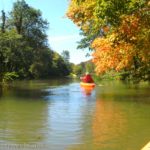
Did you know that you can paddle up the Genesee River to the very impressive Lower Falls? I certainly didn’t know it until recently, when I got a book about local paddle routes out of the library. You know what else? It has amazingly natural scenery along the route, despite going through a very urban part of Rochester. Sure, there are three bridges over the river, the outlet of the storm sewers, a water treatment plant, and a few visible high rises/smokestacks. But in general, you’re paddling between marshy shores below forested gorge walls for the four or more miles to Lower Falls. It’s even more beautiful in the autumn when the trees are colorful. And the view of Lower Falls from the end of the paddle is amazing!
Quick Stats
(Affiliate links are present on this page.)

I started at Turning Point Park. There are two problems with starting here: 1) you’ll have to carry your kayak or canoe down a very steep hill from Boxart Street to river level (that’s about a quarter mile each way), and 2) if the water in Lake Ontario (and therefore this part of the Genesee) is low, there’s no easy way to launch the boats. For the first problem, at least there’s a paved pathway down the hill, and a cart could come in handy. For the second problem, we found a creative solution:

Not that I recommend our method of launching the kayaks! If the water is higher, you can launch from the bottom of the stairs. But the water had receded too far for us to plop the kayaks in the water, and that mud looked like it had who-knows-what in it, so we didn’t really want to go wading in it.

I hear there’s a very nice canoe/kayak launch down closer to Ontario Beach Park (it may or may not cost $7-$10 to launch) and I hear Shumway Marine allows free kayak launch (as of 2004). But you’ll have to check those out for yourself. The reason I didn’t want to start that far north is because it adds 1.7 miles each way to your kayak trip. We couldn’t start until afternoon, so we weren’t exactly looking to make our trip longer.

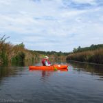
Once we finally got the kayaks in the water (thanks to my very strong brother – I couldn’t have done it!) we started paddling upstream (right/south). We very quickly passed by a huge laker unloading its cargo at the cement factory on Boxart Street. It was exactly the same laker that “just happened” to be unloading the first time I biked the Genesee Riverway. It was super cool to be that close to such a huge boat.

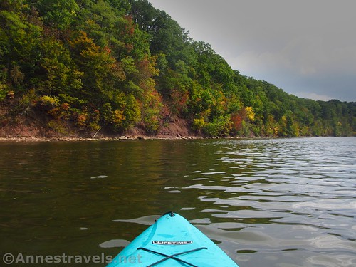
After that, the river quiets down, with rotting docks on the right turning into marshes on both sides of the river. In the spring, there could be quite the current. In the fall during a drought, it was pretty much backed up due to low lake levels, so while there was certainly current, the breeze coming upriver overcame the current and then some. There were a few motorboats (especially on our way back; the salmon fishers were out!), but they gave us a wide berth and were very respectful (even as we got out of their way).
The first real excitement is heard more than seen, about 2 miles from Turning Point Park: over on the right, there is a small waterfall. It’s not very natural, but it is pretty.

Keep kayaking upriver. After another 0.6 miles, you’ll pass the water treatment plant on the right, the outlet of the storm sewers (signs say to keep out), and go under the footbridge between Maplewood Park (right) and Seneca Park (left). Actually, that’s part of why this area is so natural: you’re surrounded by parks! In fact, I saw more birds in the 0.4 miles between the two bridges than anywhere else on the river.

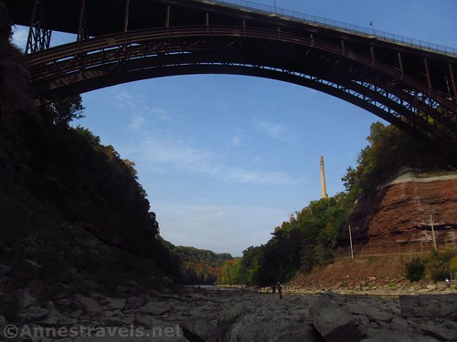
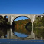
Fairly quickly after this, you’ll pass under the Veterans Memorial Bridge (better known to me as the Rt. 104 Bridge into Kodak Park). It reminds me of something out of Medieval Europe, and in the fall, the views are definitely best looking back from the southern side.

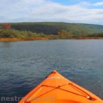
Almost immediately after the Veterans Memorial Bridge, you’ll come to an island. This is as far as most motorboats venture. In higher water, you could probably go on either side of the island, but we went on the right (west) side and were thankful we did so. The water gets progressively shallower with more rocks in the water (keep a good eye out!) as you continue beyond the island. The current picked up a little bit, too. I’d expect this section of river would be a challenge in the spring.

At last, almost another mile beyond the Veterans Bridge, you’ll pass under one more bridge (Driving Park Avenue); the falls are just beyond this. On our visit, there were people fishing for salmon up and down the river at this point. We tried to stay to the west side of the river (sort of hard at times because of the rocks under the water) to keep out of their way.

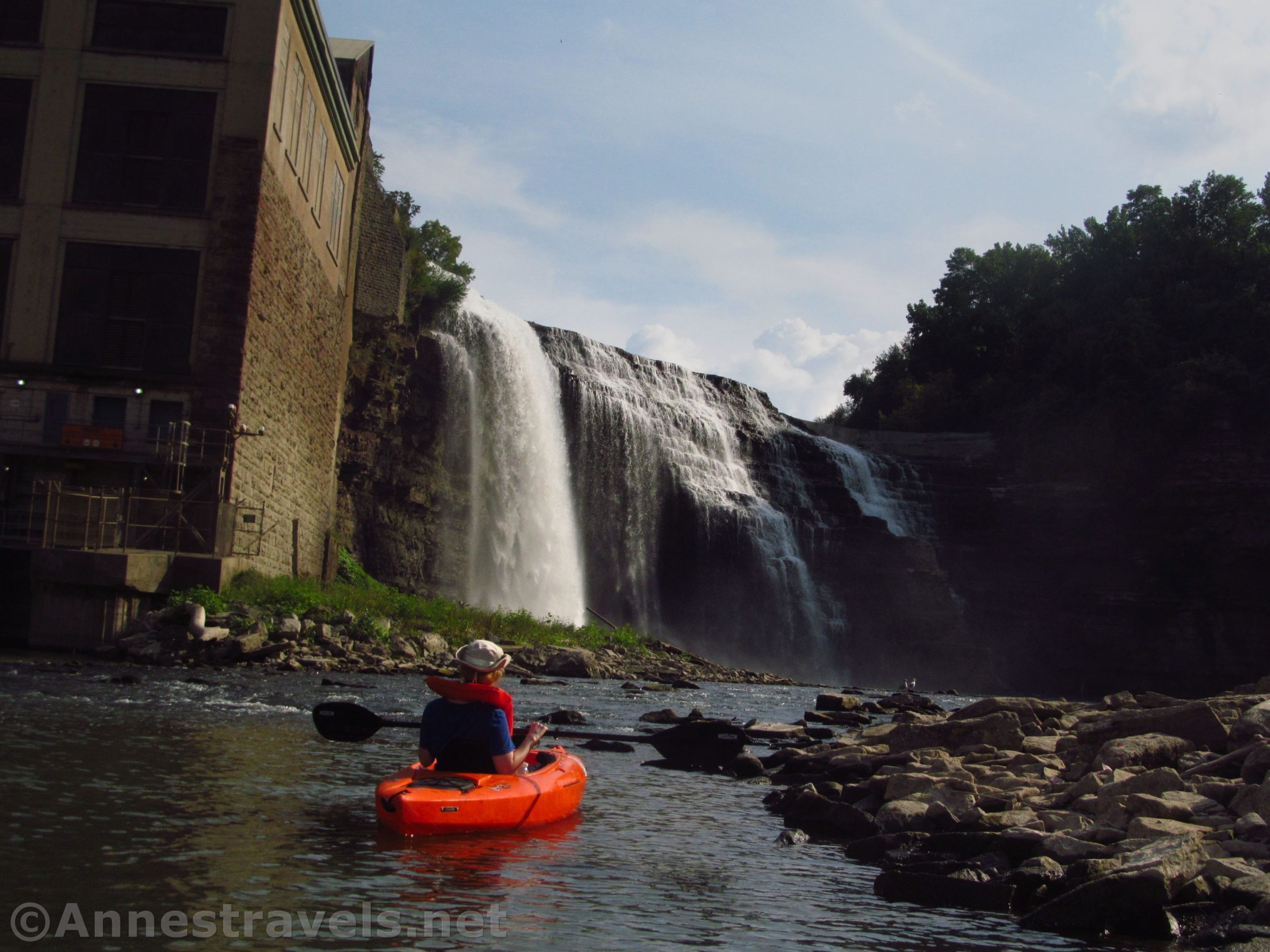
To the left of the falls is RG&E Station 5 Hydroelectric Plant. It looks like it’s seen better days but is still producing power. Signs say that if a warning sounds, you should leave the gorge immediately – they’re about to let through a flood of excess water. I figured we weren’t in too much danger at this time of year, but we kept our ears open anyway.

You can only go so far up toward the falls (at least during this dry spell). We pulled out kayaks up on the rocks and scrambled up closer to the falls on foot. The views were great, even if the gorge blocked the sunlight from much of the falls.

And that’s it! Kayak back down to where you launched. Overall, while it was a long paddle, I enjoyed it – and the Lower Falls at the end made it so worth it!

Round Trip Paddle Length: 8 miles from the Turning Point Park launch
Elevation Gain: Minimal, though my gps map said it’s about 110ft.
Facilities: None
Fees: None
Paddle Notes: The current water flow will dramatically change how easy or hard this paddle is. In late September in the middle of a drought, the flow was minimal and the paddle slightly more difficult than a lake. The current flow will also dictate how much water is on Lower Falls – though it flows nicely no matter how dry the weather.

Ease of Paddle 
![]()
Road ![]()
Signs ![]()
![]()
![]()
![]()
Scenery ![]()
Would I go 100 miles out of my way for this? ![]()
Overall Rating: 
![]()

GPS Coordinates for Turning Point Park/Genesee River Paddle to Lower Falls
Parking area at the end of Boxart Street: 43.227836, -77.617750 (43°13.67016′, -077°37.06500′ / 43°13’40.2096″, -077°37’03.9000″)
Fishing platform in Turning Point Park: 43.230659, -77.616671 (43°13.83954′, -077°37.00026′ / 43°13’50.3724″, -077°37’00.0156″) (244ft.) (0.0)
Base of Waterfall : 43.204907, -77.627130 (43°12.29442′, -077°37.62780′ / 43°12’17.6652″, -077°37’37.6680″) (262ft.) (2.08)
Pedestrian Bridge between Maplewood Park and Seneca Park: 43.197840, -77.620541 (43°11.87040′, -077°37.23246′ / 43°11’52.2240″, -077°37’13.9476″) (255ft.) (2.66)

Veterans Memorial Bridge: 43.1925860°, -077.6205780° (43°11.55516′, -077°37.23468′ / 43°11’33.3096″, -077°37’14.0808″) (256ft.) (3.04)
Driving Park Avenue Bridge: 43.1810470°, -077.6282280° (43°10.86282′, -077°37.69368′ / 43°10’51.7692″, -077°37’41.6208″) (279ft.) (3.97ft.)
Lower Falls: 43.179927, -77.628298 (43°10.79562′, -077°37.69788′ / 43°10’47.7372″, -077°37’41.8728″) (355ft.) (4.07)
The gpx file for the Genesee River from Turning Point Park to Lower Falls can be downloaded – please note that this and the GPS Coordinates are for reference only and should not be used as a sole resource when paddling this route.
Download GPX File size: 20.4 KB Downloaded 408 times
(Note: I do my best to ensure that all downloads, the webpage, etc. are virus-free and accurate; however, I cannot be held responsible for any damage that might result, including but not limited to loss of data, damages to hardware, harm to users, from use of files, information, etc. from this website. Thanks!)

Getting to Turning Point Park Kayak/Canoe Launch
From Rt-104 (either east of the Genesee River or Kodak area/Greece), drive to Lake Avenue and turn north (left from Kodak, right from the Veterans Memorial Bridge). After 2.2 miles, turn right onto Boxart Street (there is a light). You’ll need to turn right again almost immediately. Take Boxart Street to its end at a medium-sized parking area. Park here (assuming the gates are closed – like they usually are – and you can’t just drive down to river level) and carry your craft down the paved trail/road to river level. The parking area can be a bit busy in the evening and also on nice weekends.

From the Ontario State Parkway, drive to Lake Avenue and turn south. Boxart Street (it has a light) will be on the left after 1.7 miles. Turn left; take a quick right, and then drive to the road’s end at a medium-sized parking area. Park here (assuming the gates are closed – like they usually are – and you can’t just drive down to river level) and carry your craft down the paved trail/road to river level. The parking area can be a bit busy in the evening and also on nice weekends.

This Week’s Featured Product!
It’s not exactly easy to get your hands on this book, but boy, does it have ideas for kayakers and canoeists! The guide covers 45 different routes in western New York, from Rochester and Buffalo to the Pennsylvania border.
More Related Posts:
 Kayaking Black Creek: Churchville to 6.2 Miles
 Paddling Irondequoit Creek – Ellison Park to Irondequoit Bay
 Autumn in the Genesee River Gorge
 Pictures from Honeoye Lake, October 2018
 Genesee Riverway – Ontario Beach Park, Turning Point Park, & Maplewood Park
 The Best Kayaking/Canoe Adventures & Water Trails near Rochester, New York