
One of my dad’s favorite treks we did last fall was kayaking on Black Creek, near the Genesee River south of Rochester. It was a perfect day – sunny, with the leaves turning color, and few mosquitos due to having already experienced a frost. While I enjoyed the Erie Canal a couple of days earlier, he loved the adventure of the twisting creek, a couple of train bridges, and the great aura of paddling through a forest. Of course, there were a few downed trees over the creek, and it was rather loud at times due to trains and airplanes, but that’s all in a day’s paddle, right?
Quick Stats
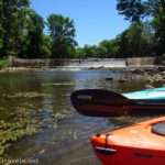
We put in at the Black Creek Boat Launch. For all you Rochestarians who know the area, the launch is right next to East River Road, south of the airport and west of the RIT campus, though it’s accessed off of Ballantyne Road (Rt-252). It’s just upstream of where Black Creek enters the Genesee, so at the end of our paddle we kayaked out to the Genesee River just for fun (more on that later).

The boat dock is very conducive to kayak launching (by far the easiest I’ve ever used and technically wheelchair-friendly); you can also launch canoes and small motorboats. We launched and headed upcreek (left/west). Almost immediately, the creek splits; head right-ish but stay in the main channel.

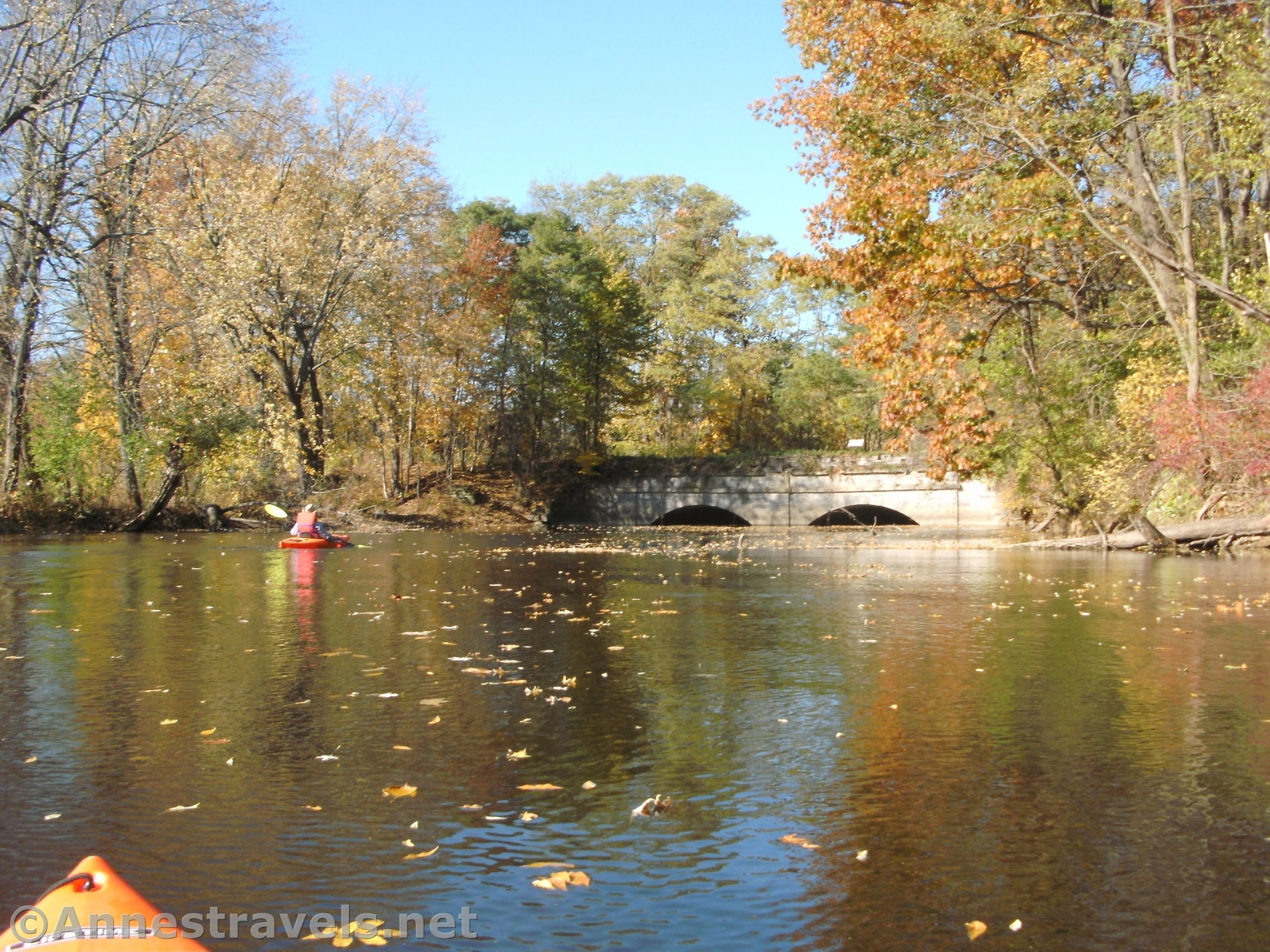
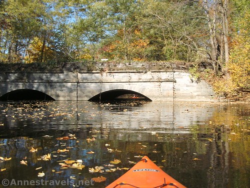
After about 0.3 miles, the first interesting feature comes into view. It’s an old rail bridge spanning the river. Today, it’s part of the Genesee Valley Greenway (north of where we ended). I hear there’s an old turntable just north of the bridge, but since I don’t know anything about it or whether it’s on private property, I’m not going to suggest you go there.
If the creek is high, you’ll have some trouble going under the bridge. The water was high-but-not-too-high when I was kayaking, so we had to duck considerably but we could still get through. A craft that sat higher in the water than a kayak might not be able to get through even in slightly lower conditions. This the furthest you’ll see motorboats on this stretch of creek (not that they usually come up here anyway).
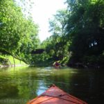
The water is sluggish on the other side of the bridge. Current creek levels, the last flood, and other environmental factors will impact the exact route and how many trees you have to duck under. Some are just low-hanging branches; others are tall and straight poplars that have fallen across the creek. As you pass behind some people’s houses, the current quickens. You’re going upstream, so it will be easier coming back.
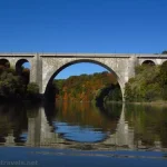
At 1.8 miles, you’ll round a bend and see an ancient-looking concrete railroad bridge (honestly, in some ways it looks older than the disused one you already went under). This is a CSX Rochester & Southern Railroad bridge for an active line. If you’re lucky, you’ll see a train. After the CSX Rochester & Southern bridge, the river, which has been narrowing for some time, more or less settles itself into a general rhythm of twists and turns with fewer swamps and side channels.

At some point (I’d guess 2.5-2.9 miles from where we put in) we arrived at a tree across the river. There had been several downed trees up to this point, but this one was going to require portaging. Between the fact that the riverbank seemed to be covered in poison ivy and the distance we’d already gone, we decided to eat lunch on a slightly less foliaged part of the riverbank and then go back. We’re glad we did since the river beyond this had many, many required portages.

Before pulling out (also the easiest I’ve ever done, thanks to the helpful kayak launch), we continued down Black Creek to the Genesee River. It’s only about 0.1 or 0.2 miles out to the river. We turned right just to see what it was like pulling against the current. Answer: There’s a dam in the river down in Rochester and so this section of the Genesee River was almost like a lake. It wasn’t hard at all to go upstream or downstream. We went up under the first bridge and then came back.

Overall, I’d guess we went about 9 or 9.25 miles. (I’m surprised I didn’t have my GPS tracking since it’s waterproof… but I have no record of it and it’s sense lost some of its memory, so either way I don’t have the track.) It’s a great little paddle if you like new scenery around every bend of the river. Though you’ll have to have a sense of adventure – there are plenty of trees to duck under!

Round Trip Paddle Length: I hear you can go all the way up to Churchville if there is enough water (you’ll probably need to portage around a few trees). I personally went about 9 miles before encountering my first portage. I also read that Black Creek above Churchville Dam is quite a bit deeper and easier to paddle than the lower section.
Elevation Gain: Very little
Facilities: There was a port-a-potti at the Black Creek Boat Launch when I visited
Fees: None
Paddle Notes: The success of this paddle is very much dependent on water levels. We’d had a fair amount of rain recently but we could make it under the Genesee Valley Greenway Bridge. The lower the water, the easier to get under obstacles and the harder to get over shallow sections of the river. I had little or no trouble with shallow sections.
River 
![]()
![]()
Road ![]()
Signs ![]()
![]()
![]()
Scenery ![]()
![]()
![]()
Would I go 100 miles out of my way for this? ![]()
![]()
Overall Rating: ![]()
![]()

GPS Coordinates for My Paddle up Black Creek
Boat Launch: 43.094640, -77.681523 (43°05.67840′, -077°40.89138′ / 43°05’40.7040″, -077°40’53.4828″)
Genesee Valley Greenway Bridge: 43.097487, -77.687200 (43°05.84922′, -077°41.23200′ / 43°05’50.9532″, -077°41’13.9200″)
CSX Bridge: 43.093768, -77.705526 (43°05.62608′, -077°42.33156′ / 43°05’37.5648″, -077°42’19.8936″)
Approximately where we stopped: 43.094406, -77.718240 (43°05.66436′, -077°43.09440′ / 43°05’39.8616″, -077°43’05.6640″)
The gpx file for an approximate route of my paddle up Black Creek can be downloaded – please note that this and the GPS Coordinates are for reference only and should not be used as a sole resource when paddling the creek. (I made this track later via a map program on the internet – it is not an exact representation of my paddle.)
Download GPX File size: 10.1 KB Downloaded 529 times
(Note: I do my best to ensure that all downloads, the webpage, etc. are virus-free and accurate; however, I cannot be held responsible for any damage that might result, including but not limited to loss of data, damages to hardware, harm to users, from use of files, information, etc. from this website. Thanks!)

Getting to the Black Creek Boat Launch
From I-390, take Exit 17 onto Scottsville Road (this is one exit east from the Airport). Take a right onto Scottsville Road to drive south 3.3 miles. Turn right onto Ballantyne Road (Rt-252; it would be Jefferson Road if you turned left) for 0.1 miles. Turn right onto Black Creek Road. At the end of the street, turn right. Go to the end of the street and turn left. You should be in the parking area for the Black Creek Boat Launch.
From I-490, take Exit 4 toward North Chili and West Chili (for all you non-natives, it’s pronounced “Chie-lie”). At the end of the exit ramp, turn south to the first intersection. Turn left on NY-33A E for 1.7 miles, then turn right onto NY-252E for 4.4 miles. Shortly before the stoplight, turn left onto Black Creek Road. At the end of the street, turn right. Go to the end of the street and turn left. You should be in the parking area for the Black Creek Boat Launch.
From I-90, take Exit 46 for I-390N toward Rochester. After only 0.9 miles, keep right, following signs for NY-253W and NY-15W. Just 0.5 miles later, turn left onto 253W for 0.6 miles; the road becomes Lehigh Station Road. Continue 1.9 miles; turn right onto E River Road for 2.5 miles. Turn left onto Jefferson Road to cross the Genesee River; after 0.3 miles, turn right onto Black Creek Road. At the end of the street, turn right. Go to the end of the street and turn left. You should be in the parking area for the Black Creek Boat Launch.

This Week’s Featured Product!
If you want ideas for even more paddling adventures in western New York State, check out this book written by locals. The guide covers 45 potential routes, from quiet ponds to rivers safe for paddling.