
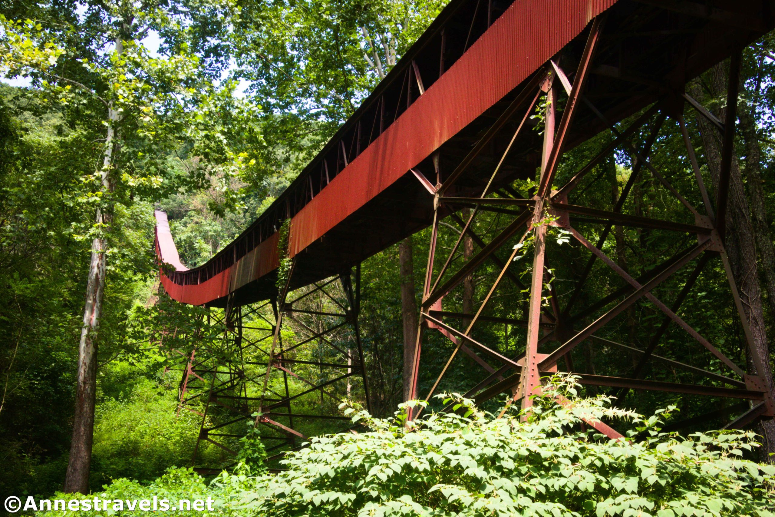

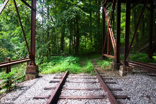
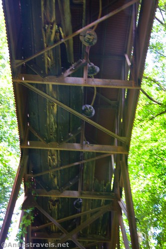
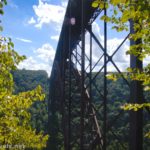
Did you know that you can visit old coal mining camps in New River Gorge National Park? The most famous of these camps is accessed via the Kaymoor Miners Trail on the Fayetteville side of the gorge (not far from the Long Point Trailhead). However, I opted to take the drive and walk to Nuttallburg instead (on the visitor center side of the gorge). It’s a crazy drive (high clearance recommended; the gravel road is very steep and narrow), but it’s also fascinating with so much to see and explore. I especially enjoyed photographing the tipple – a long conveyer that brought coal from the mine (high on the hillside) down to the railroad tracks.
Quick Stats
Note: Some of the links in this post are affiliate links. If you click one and purchase something, I may earn a small commission without an extra cost to you.

Talking with the rangers, they discouraged me from visiting Nuttallburg. First, because it’s a long drive. Second, because the road is so steep and winding. And third, because it’s not like you’re going to spend hours there. Every single one of these points is valid and reasonable, and I’m grateful for the rangers for warning me ahead of time. But I also really enjoyed my visit and would highly recommend it if you can get over the road and the time required to get there.
We drove down the road as a storm blew over the New River Gorge. The wind whipped the trees that grow almost up to the edge of the road, and the river along the road roared with the rainfall of the day before. However, thankfully, it didn’t do much more than spitter-spatter raindrops on the windshield.
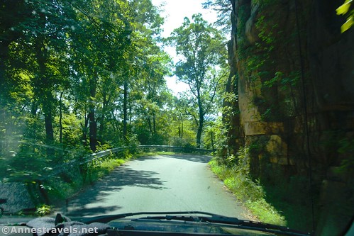
We got to about 3/4 of a mile before the end of the road and found that the road turned to muddy gravel going uphill. I happened to be driving, so, looking nervously and hoping no one was coming in the other direction, I charged up the incline. It was the first time on the road that I needed high clearance, and I wouldn’t have minded a bit of 4×4 right then.

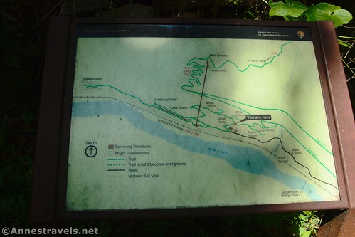
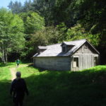
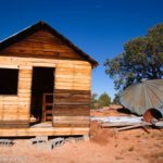
Right about here (at the top of the hill, if I remember correctly) is a signboard about Nuttallburg, its founder, etc. The Black Church and the Black School are also nearby – according to the signs, besides the segregation, people of other races were actually treated quite fairly when it came to mining and living in the community.

The road crosses over Short Creek (with some pretty waterfalls) and then descends to the main parking area. Park here. The road continues a short distance to a parking area for those with a handicap tag.

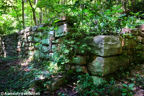
A couple of trails leave from the main parking area. For now, walk up the road past the handicapped parking spaces and then left around an old ruin to the end of the tipple.

I dropped down along the old railroad tracks first to walk under the end of the tipple. It’s pretty amazing to see how it likely worked in days of yore.

Nuttallburg was created by John Nuttall in 1870. Mr. Nuttall built infrastructure to extract the coal, hired miners, and generally turned it into a profitable operation. His descendants continued to run the mine into the 1920s, when the mine was purchased by Henry Ford. Ford updated and strengthened the infrastructure, including building the tipple, before he sold it in 1928. The mine changed hands several times and finally ceased production in 1958.

From there, I walked around the tipple building and then turned left to walk past some rusting machinery and into the woods. From here, I turned left again to walk along the lower side of the Coke Ovens.

These brick structures were used to take the raw coal ore, mined higher on the hill, and turn it into coke by firing it in an oxygen-deprived environment. This produced coke or “smokeless coal,” a highly sought-after product for use in blast furnaces. They say that each chamber could hold approximately 5 tons of coal.

Despite the fact that Henry Ford purchased Nuttallburg to further his steel plants, he did not use the on-site coke ovens for producing “smokeless coal.” Instead, he shipped the ore to a processing facility in another state.
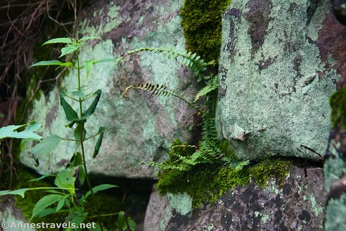
Most of the coke ovens are being taken over by weeds and wildflowers. However, many are also still in good condition. A few you can even see inside well enough to enjoy the interesting construction.

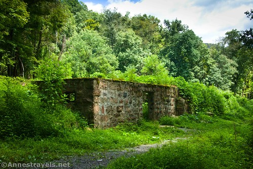
At the end of the row of coke ovens is the foundation (ruins?) of the general store. The miners were paid in tokens that could be redeemed at the store and nowhere else. Still, there must have been some money involved, since by working for about 10 years and saving their pennies, most miners could buy their own house up on the hill instead of renting a company-owned house closer to the river.

Just beyond the company store, the trail splits. The trail to the ruins of the town of Seldom Seen (yes, that’s its name) goes straight/left. We decided that we’d seen enough ruined foundations; we’d turn right and go back along the upper trail around the Coke Ovens. By this time, the sun had come out – which was a nice change of pace, especially once we got back to the tipple and were able to see it in the sunshine!

I decided to follow the social trail up under the tipple. It’s very steep as it switchbacks upward. I hear you can go all of the way up to headhouse and the entrance to the old Nuttallburg coal mine. I would have loved to do this, but my group member was waiting down below, and I didn’t want to leave him too long. Besides, we had other places we wanted to visit before the day was out (namely, taking the old road across the gorge and then hiking out to Long Point – my favorite hike in New River Gorge).

So I hiked maybe halfway up and then took the trail to the right over to the White Church, White School, and a few other foundations. The trail (if you follow the signs) will take you back down to the parking area.
And that’s that! It’s not a place where you’d want to spend hours and hours, and as I said before, it’s far enough away from the visitor center and Fayetteville that you’d better really want to see it. But it is a great place to learn about the history of coal mining in West Virginia and see some cool old mining ruins!

Round Trip Trail Length: I walked a total of 1.4 miles
Elevation gain: Including walking up the hill under the tipple, I gained 370ft. (959ft. to 1,095ft.)
Facilities: They say there are primitive restrooms at the trailhead – I don’t recall seeing them, but they’re probably just tucked back in the trees slightly.
Fees: None

Trail Notes: It should go without saying that you should stay off of/out of all of the historical features. You can hike all of the way up to the rim of the gorge if you want to, but it’s highly discouraged due to the steep trail and loose cinders that make up the tread. (I didn’t have any problem with it, so it must start higher than I went.) An active rail line does pass just below Nuttallburg, so you may hear or even see the tops of rail cars flashing by at one point or another during your visit.
Trail 
![]()
![]()
Road ![]()
![]()
Signs ![]()
Scenery ![]()
![]()
![]()
Would I go 100 miles out of my way for this? ![]()
![]()
Overall Rating: ![]()
![]()
GPS Coordinates for Nuttallburg
Black Church ruins: 38.049060, -81.036643 (38°02.94360′, -081°02.19858′ / 38°02’56.6160″, -081°02’11.9148″) (1,001ft.)
Trailhead: 38.050131, -81.040081 (38°03.00786′, -081°02.40486′ / 38°03’00.4716″, -081°02’24.2916″) (970ft.) (0.0)
Ruins: 38.050536, -81.041951 (38°03.03216′, -081°02.51706′ / 38°03’01.9296″, -081°02’31.0236″) (973ft.) (0.11)
Seldom Seen Junction: 38.051586, -81.045365 (38°03.09516′, -081°02.72190′ / 38°03’05.7096″, -081°02’43.3140″) (991ft.) (0.56)

White Church: 38.051380, -81.041045 (38°03.08280′, -081°02.46270′ / 38°03’04.9680″, -081°02’27.7620″) (1,094ft.) (1.11)
White School: 38.050920, -81.039775 (38°03.05520′, -081°02.38650′ / 38°03’03.3120″, -081°02’23.1900″) (1,053ft.) (1.26)
Trail junction: 38.050529, -81.039799 (38°03.03174′, -081°02.38794′ / 38°03’01.9044″, -081°02’23.2764″) (1,016ft.) (1.33)
End: 38.050131, -81.040151 (38°03.00786′, -081°02.40906′ / 38°03’00.4716″, -081°02’24.5436″) (970ft.) (1.43)

The gpx file for Nuttallburg can be downloaded – please note that this and the GPS Coordinates are for reference only and should not be used as a sole resource when hiking this trail.
Download GPX File size: 30.3 KB Downloaded 479 times
(Note: I do my best to ensure that all downloads, the webpage, etc. are virus-free and accurate; however, I cannot be held responsible for any damage that might result, including but not limited to loss of data, damages to hardware, harm to users, from use of files, information, etc. from this website. Thanks!)

Getting to Nuttallburg
From the New River Gorge Visitor Center, drive back out to the main road (US-19; the road that crosses the New River Gorge Bridge) and turn right (away from the bridge). Take the next right onto Lansing-Edmond Road. The road is winding and somewhat narrow as it passes by the Endless Wall Trailhead and the Nuttall Trailhead. Keep driving on the very rural, but still paved, road that winds through forests and farmland. It’s only 6 miles to the next turn (in the settlement of Winona), but it feels like much more. Turn right onto Keeneys Creek Road in the town. From here, it’s 4.1 miles on the increasingly rough, eventually gravel road through the forest to the Nuttallburg Parking Area.
Note that the road is very steep, very winding, and is often only one lane wide. If you meet another vehicle, one of you will probably have to back up until you can get to a wide spot in the road. This is especially true once you leave Keeney Creek to travel north to the parking area.

This Week’s Featured Product!
Explore 20 different hikes in and near New River Gorge National Park with this book. It covers easy day hikes, so you’ll be able to see quite a bit of what the park has to offer in a single day. Buy it here!

More Related Posts:
 Driving the Fayette Station Road & Views of the New River Gorge Bridge
 Finding Butch Cassidy’s Cabin at Robber’s Roost
 Day-hiking Coyote Gulch: Waterfalls, Arches, and Solitude
 Visiting Redwood’s WWII-era Klamath River Radar Station
 Genesee Valley Greenway-Lehigh Valley Trail Loop in Rochester!
 French Cabin in the Maze District