
Would you believe that there are national parks within a few hours of my childhood home that I’ve never visited? They just never seem to fit into any trip: Too far away for a day trip, too close as a destination, too inconvenient to be tacked onto a trip en route elsewhere. So I was super excited to finally jump on the opportunity to visit not one but two (!) new-to-me national parks last week!

To be honest, I had planned an entirely different trip, down to the Virginia Blue Ridge. But the weather didn’t look great, so we headed for Ohio instead of Maryland. After all, I’d put together a document of information on Cuyahoga Valley National Park last fall, but that trip fell through at the last minute.

As we drove along, my hiking companion said, “We’re not that far from Cleveland. Why don’t we do the Presque Isle bike ride tonight?” I enthusiastically agreed – we’d both had our eye on the trail for some time, and the evening light seemed to be the perfect way to see it. As it turned out, the weather was delightful for an evening bike ride about 13-ish miles around Presque Isle State Park. We even got to watch the sunset over Lake Erie!

The next morning, we arrived at Cuyahoga Valley National Park very early. Unfortunately for us, the Brandywine Falls parking area was closed for a resurfacing project, so we had to hike in from the Stanford House Trailhead. Fortunately for us, we arrived early enough that there were still parking spots at the Stanford House Trailhead – cutting a mile or two each way off of the park-recommended route from the Towpath Access Parking not too far from the visitor center. The early morning walk through the woods was nice, but probably not something I’d do again. Brandywine Falls was nice but definitely not made for early-morning viewing… the light would have been better in the afternoon.

Still, it’s a lot better than not seeing it. We did enjoy the Gorge Trail which is also accessible from the falls area.

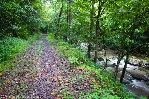
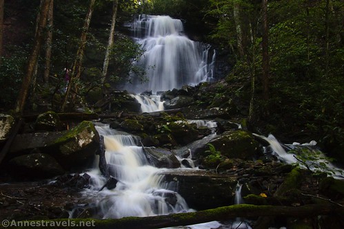
We had lunch at the visitor center (new in 2020!) and ironed out confusion over Blue Hen Falls. I had no information with me about it, because it had been closed when I’d planned the trip last fall. The closure had been (in part) to beef up the Buckeye Trail so that they could close the old parking area for Blue Hen Falls. It more than doubles the length of the trail to see the falls, but I could see how six parking spaces would be far too few for a waterfall as pretty and popular as this one.

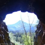
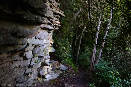
Waterfalls successfully negotiated, we drove down to the Ledges Trailhead. This turned out to be our favorite trail (besides possibly the Towpath) in Cuyahoga Valley. Once you get down below the cliffs, it’s a long, fun hike along bluffs, cliffs, rock formations, overhangs, slot canyons, moss, ferns, a (closed) cave, stone steps, and more!

The next day (yes, those three hikes were all in one day!), we parked in Peninsula to access the bike trail along the old Ohio and Erie Canal Towpath. It’s a great place to start, since you can walk right into an old lock as well as see it from above and walk across the Cuyahoga River. Fun!

The Towpath is a great bike trail, with a good mix of scenery, history, old canal locks, railroads, and more. One of the most positive things I can say for Cuyahoga National Park is that they have some of the most interesting historical signs I’ve seen in any national park. We’d see a sign and want to read it – just because we knew we’d find something fascinating. Whoever put the signs together knew how to take the interesting bits and present them in a way that you’d enjoy reading about the history of the park, canal, etc.

I’d been having trouble with my camera lens (actually, the lens adapter) for most of the trip, and it completely fell apart on the Towpath. On closer inspection, three screws had pulled out completely and the fourth was missing. A trip to Walmart as we headed south allowed us to pick up an eyeglass repair kit with a tiny screwdriver. After sixty seconds and some quick turning of the screws, my camera was back in working order. Let’s just say the screwdriver is now part of my camera kit!

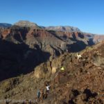
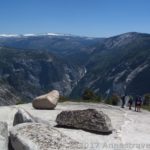
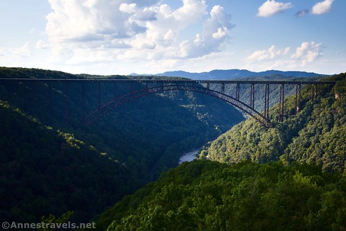
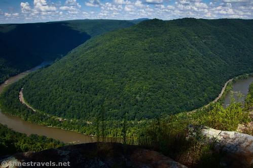
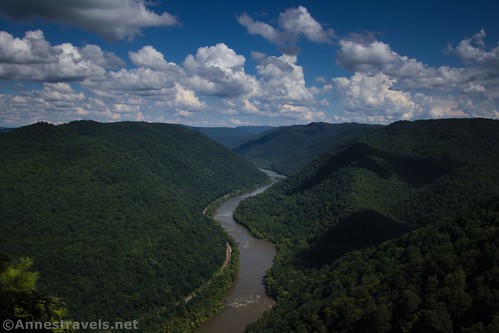
Our next destination turned out to be New River Gorge National Park. At this point, it’s the nation’s newest national park. (The national park was created, to my best understanding, to promote tourism in West Virginia from New River Gorge National River. Lesser-known trivia: Most of the national river was designated “preserve” instead of “park” so that locals can continue hunting there.) The fog was just clearing from the gorge when we arrived, so I didn’t see a thing as we crossed the New River Gorge Bridge (purportedly the third highest arch bridge in the United States and the longest steel span in the western hemisphere). We first hiked out on the Canyon Rim Boardwalk. This was one of the best views (per me – the other being Long Point) we saw all day.

I’d heard good things about the Endless Wall Trail, so we headed over to the Fern Trailhead next. The parking area is small; the other parking area along the loop (Nuttall Trailhead) is slightly larger. Most of the trail is through what some would call a “pleasant forest,” but there were some decent views as well. The views were nice but not something I’d go a long way out of my way for.

The skies were clouding over, so we decided to drive down to Nuttallburg, an old mining area at the bottom of the gorge. The road was seriously sketchy in places (recent rains hadn’t helped it), but I had a great time exploring the old tramway system, seeing the coke ovens, and discovering old foundations.

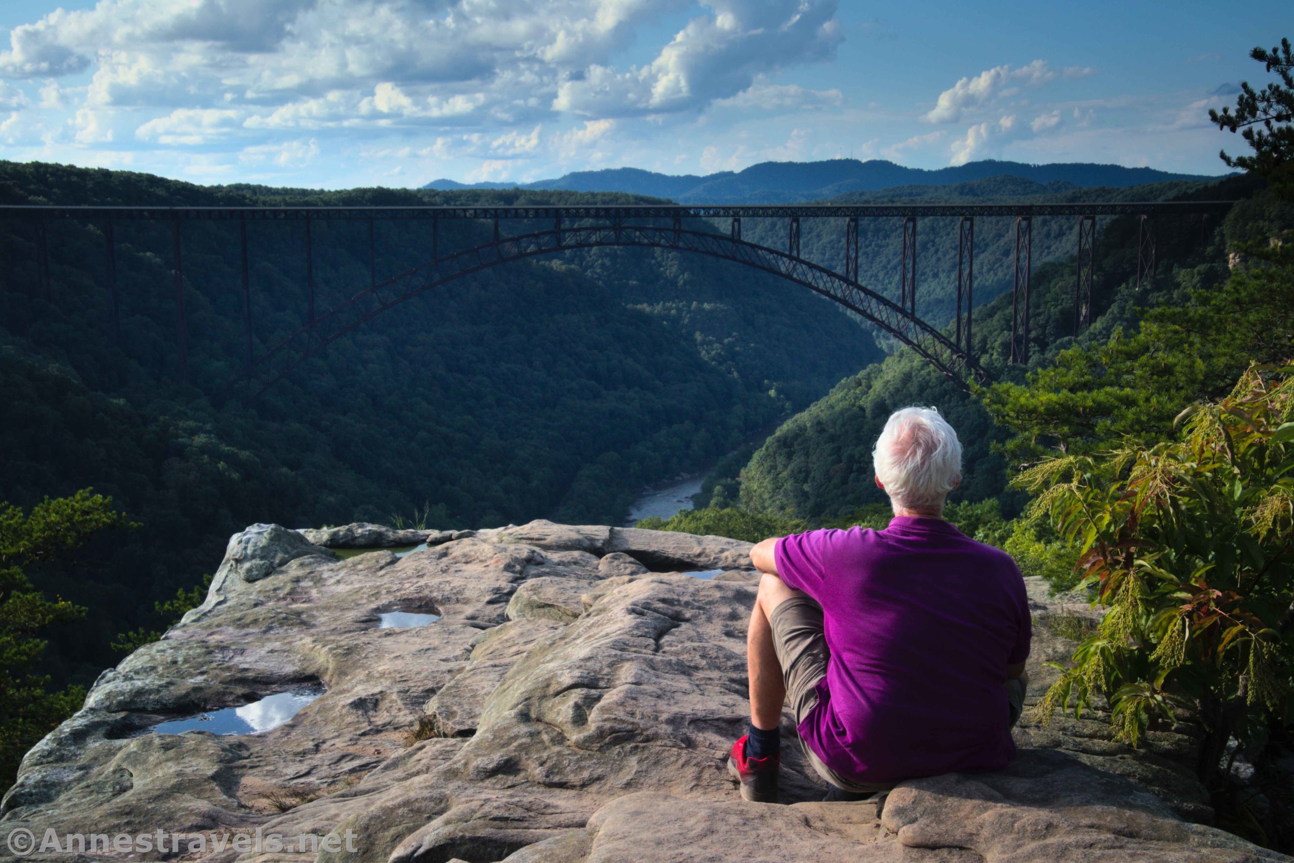
If there was one hike I wanted to make sure we did in New River Gorge, it was the Long Point Trail. To get there, we could either take the New River Gorge Bridge back across the gorge (45 seconds) or we could take the much longer but more scenic Fayette Station Road under the New River Gorge Bridge (twice!), across the Tunney Hunsaker Bridge (a reconstruction of the old Fayette Station Bridge), and then back up the other side of the gorge (45 minutes). I couldn’t pass up an opportunity to see the New River Gorge Bridge from below!

By the time we got back up, it was pushing 5pm, but I still wanted to hike out to Long Point. I’m so glad we didn’t blow it off. It’s the best view we got of the New River Gorge Bridge and you also get great views of the gorge and nearby mountains. In the evening light, it was especially special. Not to mention that afternoon rains had made a waterfall across the gorge quite something to see (I think the falls are on Fern Creek, but it’s hard to say since maps don’t log their name.)
Our plans for the next day were to bike the Glade Creek Trail from its southern end and see Kates Falls along the way. Well, that didn’t work out so well. The Glad Creek Trail ended in a total washout at the flooded Kates Creek (you can also access the trail from the north, so purportedly you can still do that part of the trail, just not from the southern end).
We hiked up to see Kates Falls, which was spectacular. However, while we were hiking around the falls, the ground gave out under my companion and he fell a very long way down the hillside into the creek. Given the fall, it was a miracle that he was essentially unhurt (scrapes and bruises), but he was very stiff for a few days (thank God for ministering angels!)
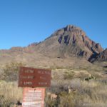
I did hike the Grandview Trail/Castle Rock loop trails in the afternoon. The views from the Main Overlook were great.
The Castle Rock Loop was also very fun, and somewhat reminiscent of the Ledges Trail in Cuyahoga Valley.
On the way back via the Grandview Trail, I loved the views from the North Overlook. In fact, I thought they were better (in some ways) than the Main Overlook!
While I was at it, I tacked on the Tunnel Trail. If you don’t want the difficulty of the Castle Rock Trail, it’s a good one; otherwise, don’t bother.

We finished off our day at Sandstone Falls. They were nice, but the drive was long enough that I’m not sure it’s worth it (unless you like scenic drives – that’s well worth it!) We stopped first at the Sandstone Falls Overlook. Talk about an unimpressive hike! It’s looking down on what’s likely whitewater 600 feet below.

Thankfully, views were better at the Sandstone Falls Boardwalk. Afternoon is definitely not the time to visit for the best lighting conditions. Still, I had a grand time exploring the social trails near the falls (the boardwalk has steps down, so why not explore?) While I was at it, I took the Island Loop, as well.

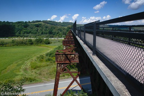
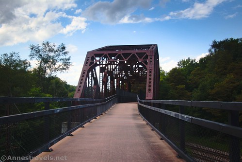
We were in somewhat of a quandary as to what we wanted to do from there. We had one more day to go and had planned to do a portion of the Great Allegheny Passage (a rail trail that travels all the way from Pittsburg, PA to Cumberland, MD where you can pick up the C&O Canal Path all the way to Washington, D.C.). But I was worried that my companion wouldn’t be able to bike. We finally decided to go for it and see what came. I was fully prepared to enact Plan B (whatever that looked like!), but we arrived and did the half mile across the Salisbury Viaduct without incident. The old trestle is nearly 2,000ft. long and over 100 feet above the valley. So cool!
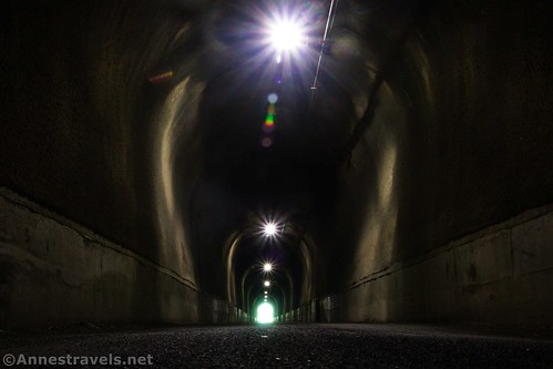
We drove over to the Deal Trailhead, had lunch, and then biked up to the Eastern Continental Divide (dividing the Chesapeake Bay watershed from the Gulf of Mexico watershed (read: Mississippi River)). Beyond that was the Great Savage Tunnel – well over 3,000ft. long through the mountain (thankfully they had lights!) And beyond that was a viewpoint and the Mason & Dixon Line. It was an awesome ride!
I decided to keep riding toward Meyersdale after we returned to the Deal Trailhead. There were a few interesting things along the way, including a couple of old rail bridges. My only complaint about the ride was going back – it’s pretty much a never-relenting 4% grade. Not so bad until you’ve been riding for five miles or so!
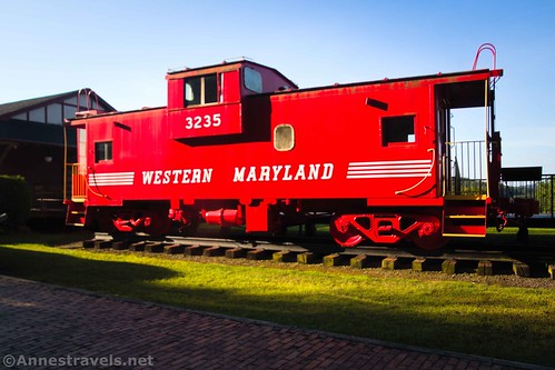
The next morning, we decided to close the gap between Meyersdale and the Salisbury Viaduct. It’s a nice ride but with the same issue of the 4% grade. The visitor center in Meyersdale was worth seeing, though – it has quite a lot of memorabilia, a model train set, gift shop, caboose, and more!
And that was our trip! Enjoy the pictures, and they’ll be more information coming over the next few months!
This Week’s Featured Product!
Written by the trail volunteers, this guide to Cuyahoga Valley National Park has over 60 paths to choose from. You’ll see waterfalls, lush forests, views, and more.